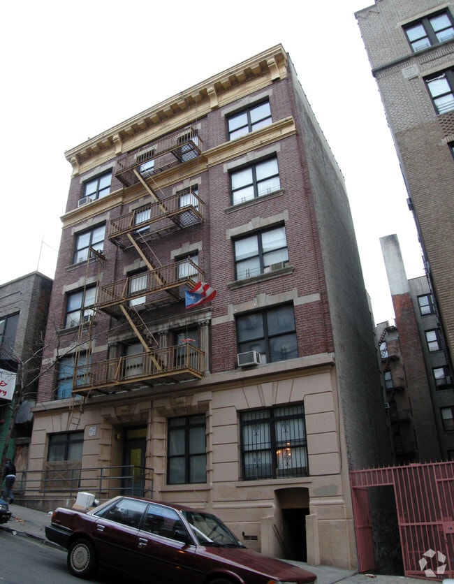
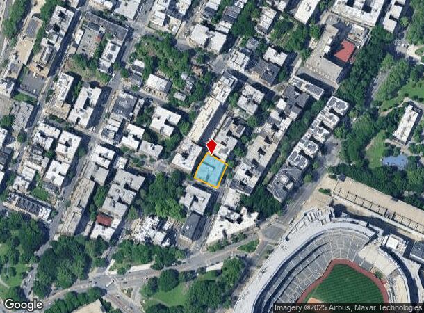
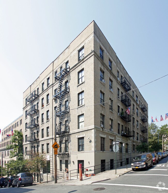
Property Record
953 Anderson Ave, Bronx, NY 10452

NEARBY LISTINGS FOR SALE OR LEASE
-
-
-
-
-
-
-
-
-
-
-
-
-
-
-
-
-
-
-
-
No Photo
-
-
-
-
-
-
-
-
-
-
-
View all Bronx listings for sale on LoopNet.com
Property Detail
953 Anderson Ave
02507-0034
Thomas Bassford
Apartment
Bronx
X
New York
3604970083F
34
0
0.27 AC
2025
Highbridge
018900
Westchester/So Connecticut
45,000 SF
New York-Jersey City-White Plains, NY-NJ
DEMOGRAPHICS near 953 Anderson Ave
1 Mile
3 Mile
5 Mile
2024 Total Population
226,559
1,244,345
2,360,798
2029 Population
211,330
1,163,241
2,199,554
Pop Growth 2024-2029
(6.72%)
(6.52%)
(6.83%)
Average Age
38
38
40
2024 Total Households
83,495
463,164
938,873
HH Growth 2024-2029
(7.30%)
(6.96%)
(7.24%)
Median Household Inc
$39,240
$41,901
$57,093
Avg Household Size
2.60
2.50
2.40
2024 Avg HH Vehicles
.00
.00
.00
Median Home Value
$395,229
$575,975
$732,838
Median Year Built
1949
1952
1952
Nearby Places
- Restaurants
- Banks
- Shops
- Fitness
- Groceries
PUBLIC TRANSPORTATION
TRANSIT/SUBWAY
161 Street-Yankee Stadium (4 - New York MTA Subway (The Subway), B - New York MTA Subway (The Subway), D - New York MTA Subway (The Subway))
DRIVE
WALK
Distance
161 Street-Yankee Stadium (4 - New York MTA Subway (The Subway), B - New York MTA Subway (The Subway), D - New York MTA Subway (The Subway))
2 min
7 min
0.4 mi
167 Street (4 Line) (4 - New York MTA Subway (The Subway))
DRIVE
WALK
Distance
167 Street (4 Line) (4 - New York MTA Subway (The Subway))
1 min
10 min
0.5 mi
167 Street (B,D Line) (B - New York MTA Subway (The Subway), D - New York MTA Subway (The Subway))
DRIVE
WALK
Distance
167 Street (B,D Line) (B - New York MTA Subway (The Subway), D - New York MTA Subway (The Subway))
2 min
13 min
0.7 mi
Harlem-148 Street (3 - New York MTA Subway (The Subway))
DRIVE
WALK
Distance
Harlem-148 Street (3 - New York MTA Subway (The Subway))
4 min
16 min
0.8 mi
155 Street (B,D Line) (B - New York MTA Subway (The Subway), D - New York MTA Subway (The Subway))
DRIVE
WALK
Distance
155 Street (B,D Line) (B - New York MTA Subway (The Subway), D - New York MTA Subway (The Subway))
4 min
16 min
0.8 mi
COMMUTER RAIL
Highbridge Yard (Hudson - Metro-North Railroad)
DRIVE
WALK
Distance
Highbridge Yard (Hudson - Metro-North Railroad)
3 min
9 min
0.5 mi
Yankees-E 153Rd Street Station (Hudson Line - Metro-North Commuter Railroad Company (Metro-North))
DRIVE
WALK
Distance
Yankees-E 153Rd Street Station (Hudson Line - Metro-North Commuter Railroad Company (Metro-North))
4 min
10 min
0.6 mi
AIRPORT
LaGuardia
DRIVE
WALK
Distance
LaGuardia
16 min
7.9 mi
John F Kennedy International
DRIVE
WALK
Distance
John F Kennedy International
29 min
19.1 mi
Newark Liberty International
DRIVE
WALK
Distance
Newark Liberty International
27 min
22.3 mi
Freight Ports
NY - Red Hook Container Terminal
DRIVE
WALK
Distance
NY - Red Hook Container Terminal
28 min
16.1 mi
Nearby Properties
Address
Land Use
TOTAL SIZE
Lot Size
Zoning
Address
Land Use
TOTAL SIZE
Lot Size
Zoning
3,693,539 SF
8.37 AC
R8
Address
Land Use
TOTAL SIZE
Lot Size
Zoning
400,160 SF
10.96 AC
R7-2
Address
Land Use
TOTAL SIZE
Lot Size
Zoning
1,299,700 SF
29.82 AC
R6
Address
Land Use
TOTAL SIZE
Lot Size
Zoning
1,743,584 SF
77.87 AC
R6
Address
Land Use
TOTAL SIZE
Lot Size
Zoning
26.93 AC
R8
Address
Land Use
TOTAL SIZE
Lot Size
Zoning
1,368,870 SF
16.86 AC
R8
Address
Land Use
TOTAL SIZE
Lot Size
Zoning
2,278,432 SF
5.99 AC
R7-2
Address
Land Use
TOTAL SIZE
Lot Size
Zoning
24.08 AC
B2-A
Address
Land Use
TOTAL SIZE
Lot Size
Zoning
4.87 AC
R11
Address
Land Use
TOTAL SIZE
Lot Size
Zoning
873,000 SF
9.95 AC
R7-2
Address
Land Use
TOTAL SIZE
Lot Size
Zoning
0.06 AC
R8
Address
Land Use
TOTAL SIZE
Lot Size
Zoning
1,670,868 SF
9.14 AC
R8
Address
Land Use
TOTAL SIZE
Lot Size
Zoning
1,651,267 SF
1.23 AC
R8
Address
Land Use
TOTAL SIZE
Lot Size
Zoning
7.64 AC
Address
Land Use
TOTAL SIZE
Lot Size
Zoning
Address
Land Use
TOTAL SIZE
Lot Size
Zoning
2.61 AC
D5
Address
Land Use
TOTAL SIZE
Lot Size
Zoning
478,842 SF
3.56 AC
C6-1
Address
Land Use
TOTAL SIZE
Lot Size
Zoning
0.36 AC
R8
Address
Land Use
TOTAL SIZE
Lot Size
Zoning
891,040 SF
5.63 AC
R8
Address
Land Use
TOTAL SIZE
Lot Size
Zoning
1,311,800 SF
9.89 AC
C4-4
Address
Land Use
TOTAL SIZE
Lot Size
Zoning
3.60 AC
OR1
Address
Land Use
TOTAL SIZE
Lot Size
Zoning
23.12 AC
PARK
Address
Land Use
TOTAL SIZE
Lot Size
Zoning
698,122 SF
3.47 AC
R8
Address
Land Use
TOTAL SIZE
Lot Size
Zoning
207.09 AC
PARK
Address
Land Use
TOTAL SIZE
Lot Size
Zoning
1,390,324 SF
6.87 AC
R8
Address
Land Use
TOTAL SIZE
Lot Size
Zoning
3.75 AC
Address
Land Use
TOTAL SIZE
Lot Size
Zoning
42.68 AC
P1
Address
Land Use
TOTAL SIZE
Lot Size
Zoning
2 AC
R11
Address
Land Use
TOTAL SIZE
Lot Size
Zoning
2.55 AC
D5
Address
Land Use
TOTAL SIZE
Lot Size
Zoning
807,327 SF
0.60 AC
R8
The World's #1 Commercial Real Estate Marketplace
Connect with us
© 2025 CoStar Group
The information above has been obtained from sources believed reliable. While we do not doubt its accuracy we have not verified it and make no guarantee, warranty or representation about it. It is your responsibility to independently confirm its accuracy and completeness. Any projections, opinions, assumptions, or estimates used are for example only and do not represent the current or future performance of the property. The value of this transaction to you depends on tax and other factors which should be evaluated by your tax, financial, and legal advisors. You and your advisors should conduct a careful, independent investigation of the property to determine to your satisfaction the suitability of the property for your needs.