Property Record
9531 Button Rd, Belding, MI 48809
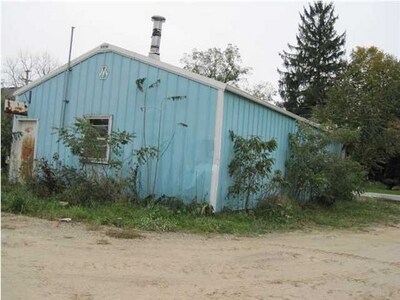

Property Detail
9531 Button Rd
130-021-000-195-10
PART OF TH SW 1/4 OF SEC 21, T8N, R8W, OTISCO TWP IONA CO MI DESC AS; COM AT THE S 1/4 CORNER OF SAID SEC; TH S90* 00' 00 W
Commercialnec
IONIA
A-C
Michigan
B and X Area of moderate flood hazard, usually the area between the limits of the 100-year and 500-year floods.
0.23 AC
2024
Ionia County
2025
West Michigan
030300
Grand Rapids-Wyoming-Kentwood, MI
960 SF
NEARBY LISTINGS FOR SALE OR LEASE
-
-
View all Belding listings for sale on LoopNet.com
DEMOGRAPHICS near 9531 Button Rd
1 mile
3 mile
5 mile
2025 Total Population
462
4,203
10,049
2030 Population
459
4,177
10,022
Pop Growth 2025-2030
(0.65%)
(0.62%)
(0.27%)
Average Age
43
40
40
2025 Total Households
179
1,608
3,833
HH Growth 2025-2030
(0.56%)
(0.62%)
(0.34%)
Median Household Inc
$58,888
$58,944
$58,473
Avg Household Size
2.60
2.50
2.50
2025 Avg HH Vehicles
3.00
2.00
2.00
Median Home Value
$269,696
$213,779
$224,274
Median Year Built
1954
1957
1964
Nearby Places
Map Layers
Map Styles
 Street
 Aerial
Transit
 Traffic
 Biking
Places
Listings with unknown addresses are not visible on the map
- Restaurants
- Banks
- Shops
- Fitness
- Groceries
PUBLIC TRANSPORTATION
AIRPORT
Gerald R Ford International
Drive
Walk
Distance
Gerald R Ford International
51 min
31.0 mi
Nearby Properties
Address
Land Use
TOTAL SIZE
Lot Size
Zoning
Address
Land Use
TOTAL SIZE
Lot Size
Zoning
Address
Land Use
TOTAL SIZE
Lot Size
Zoning
51.80 AC
I-1
Address
Land Use
TOTAL SIZE
Lot Size
Zoning
42,745 SF
3.05 AC
RM-1
Address
Land Use
TOTAL SIZE
Lot Size
Zoning
3,164 SF
4.98 AC
RM-1
Address
Land Use
TOTAL SIZE
Lot Size
Zoning
37,200 SF
13.19 AC
B-2
Address
Land Use
TOTAL SIZE
Lot Size
Zoning
5,900 SF
11.51 AC
R-2
Address
Land Use
TOTAL SIZE
Lot Size
Zoning
33.38 AC
RM-2
Address
Land Use
TOTAL SIZE
Lot Size
Zoning
2,493 SF
80.25 AC
Address
Land Use
TOTAL SIZE
Lot Size
Zoning
75,689 SF
9.46 AC
I-1
Address
Land Use
TOTAL SIZE
Lot Size
Zoning
11,048 SF
3.66 AC
RM-1
Address
Land Use
TOTAL SIZE
Lot Size
Zoning
235.27 AC
A-C
Address
Land Use
TOTAL SIZE
Lot Size
Zoning
7,440 SF
16.74 AC
B-2
Address
Land Use
TOTAL SIZE
Lot Size
Zoning
2,080 SF
160 AC
A1
Address
Land Use
TOTAL SIZE
Lot Size
Zoning
Address
Land Use
TOTAL SIZE
Lot Size
Zoning
127.59 AC
Address
Land Use
TOTAL SIZE
Lot Size
Zoning
2,457 SF
84 AC
R-C
Address
Land Use
TOTAL SIZE
Lot Size
Zoning
5,176 SF
2.43 AC
RM-1
Address
Land Use
TOTAL SIZE
Lot Size
Zoning
2,416 SF
95 AC
Address
Land Use
TOTAL SIZE
Lot Size
Zoning
2,880 SF
61.95 AC
A-C
Address
Land Use
TOTAL SIZE
Lot Size
Zoning
31,200 SF
10.78 AC
C-1
Address
Land Use
TOTAL SIZE
Lot Size
Zoning
3,666 SF
100 AC
A-C
Address
Land Use
TOTAL SIZE
Lot Size
Zoning
4,191 SF
7.58 AC
C-1
Address
Land Use
TOTAL SIZE
Lot Size
Zoning
137.17 AC
A-C
Address
Land Use
TOTAL SIZE
Lot Size
Zoning
2,758 SF
40.03 AC
A-C
Address
Land Use
TOTAL SIZE
Lot Size
Zoning
2,945 SF
2.99 AC
C-1
Address
Land Use
TOTAL SIZE
Lot Size
Zoning
1,788 SF
75 AC
R-C
Address
Land Use
TOTAL SIZE
Lot Size
Zoning
25,209 SF
13.01 AC
I-1
Address
Land Use
TOTAL SIZE
Lot Size
Zoning
2,964 SF
1.14 AC
B-2
Address
Land Use
TOTAL SIZE
Lot Size
Zoning
10,100 SF
5.27 AC
I-1
Address
Land Use
TOTAL SIZE
Lot Size
Zoning
3,242 SF
25.45 AC
A-C
The World's #1 Commercial Real Estate Marketplace
Connect with us
© 2026 CoStar Group
The information above has been obtained from sources believed reliable. While we do not doubt its accuracy we have not verified it and make no guarantee, warranty or representation about it. It is your responsibility to independently confirm its accuracy and completeness. Any projections, opinions, assumptions, or estimates used are for example only and do not represent the current or future performance of the property. The value of this transaction to you depends on tax and other factors which should be evaluated by your tax, financial, and legal advisors. You and your advisors should conduct a careful, independent investigation of the property to determine to your satisfaction the suitability of the property for your needs.