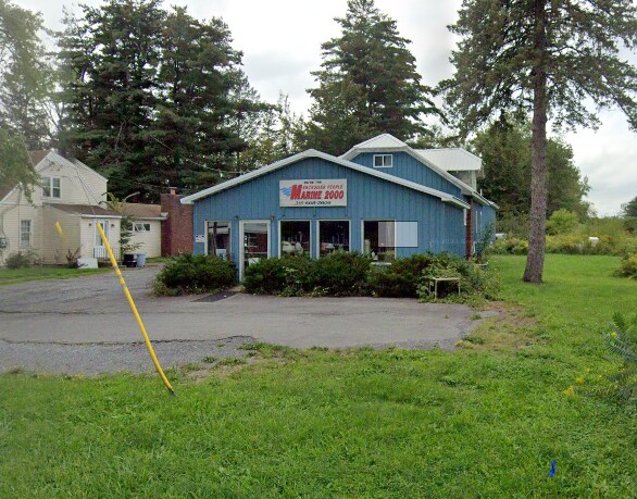
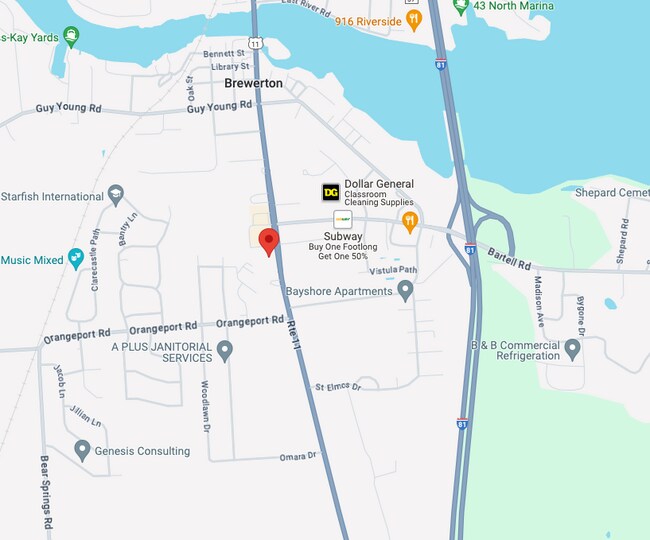
Property Record
9533 Brewerton Rd, Brewerton, NY 13029

Property Detail
9533 Brewerton Rd
312289-116-000-0001-008-000-0000
Onondaga
Commercialofficeresidentialmixeduse
New York
B and X Area of moderate flood hazard, usually the area between the limits of the 100-year and 500-year floods.
8.000
2025
0.45 AC
2024
NE Outer Onondaga County
010200
Syracuse
2,232 SF
Syracuse, NY
NEARBY LISTINGS FOR SALE OR LEASE
-
-
View all Brewerton listings for lease on LoopNet.com
DEMOGRAPHICS near 9533 Brewerton Rd
1 mile
3 mile
5 mile
2025 Total Population
3,570
7,449
32,811
2030 Population
3,496
7,409
32,484
Pop Growth 2025-2030
(2.07%)
(0.54%)
(1.00%)
Average Age
41
43
43
2025 Total Households
1,505
3,078
13,078
HH Growth 2025-2030
(2.26%)
(0.65%)
(0.98%)
Median Household Inc
$101,195
$103,505
$107,793
Avg Household Size
2.30
2.30
2.50
2025 Avg HH Vehicles
2.00
2.00
2.00
Median Home Value
$220,339
$252,377
$237,792
Median Year Built
1983
1982
1983
Nearby Places
Map Layers
Map Styles
 Street
 Aerial
Layers
 Traffic
 Biking
Places
Listings with unknown addresses are not visible on the map
- Restaurants
- Banks
- Shops
- Fitness
- Groceries
PUBLIC TRANSPORTATION
AIRPORT
Syracuse Hancock International
Drive
Walk
Distance
Syracuse Hancock International
16 min
11.0 mi
SALE & LEASE HISTORY
LISTING DATE
SALE/LEASE

May 28, 2024
For Sale
Aug 14, 2024
For Lease
Nearby Properties
Address
Land Use
TOTAL SIZE
Lot Size
Zoning
Address
Land Use
TOTAL SIZE
Lot Size
Zoning
150,670 SF
31.81 AC
CR
Address
Land Use
TOTAL SIZE
Lot Size
Zoning
8,417 SF
13.95 AC
Address
Land Use
TOTAL SIZE
Lot Size
Zoning
1,568 SF
330.36 AC
Address
Land Use
TOTAL SIZE
Lot Size
Zoning
39,128 SF
17.22 AC
Address
Land Use
TOTAL SIZE
Lot Size
Zoning
660 SF
9.75 AC
WH
Address
Land Use
TOTAL SIZE
Lot Size
Zoning
3,724 SF
56.89 AC
N00
Address
Land Use
TOTAL SIZE
Lot Size
Zoning
51,587 SF
10.37 AC
Address
Land Use
TOTAL SIZE
Lot Size
Zoning
116,020 SF
15.72 AC
PUD
Address
Land Use
TOTAL SIZE
Lot Size
Zoning
39,591 SF
7.39 AC
Address
Land Use
TOTAL SIZE
Lot Size
Zoning
12,978 SF
3.71 AC
PUD-R
Address
Land Use
TOTAL SIZE
Lot Size
Zoning
56,215 SF
7.31 AC
Address
Land Use
TOTAL SIZE
Lot Size
Zoning
11.96 AC
Address
Land Use
TOTAL SIZE
Lot Size
Zoning
42,210 SF
62.23 AC
N00
Address
Land Use
TOTAL SIZE
Lot Size
Zoning
7,500 SF
21.82 AC
CI
Address
Land Use
TOTAL SIZE
Lot Size
Zoning
46,400 SF
4.39 AC
W
Address
Land Use
TOTAL SIZE
Lot Size
Zoning
1,900 SF
144.90 AC
01 - NOT Z
Address
Land Use
TOTAL SIZE
Lot Size
Zoning
13,576 SF
1.98 AC
Address
Land Use
TOTAL SIZE
Lot Size
Zoning
13,576 SF
1.98 AC
Address
Land Use
TOTAL SIZE
Lot Size
Zoning
19,127 SF
1.98 AC
Address
Land Use
TOTAL SIZE
Lot Size
Zoning
39,875 SF
2.83 AC
01 - NOT Z
Address
Land Use
TOTAL SIZE
Lot Size
Zoning
6,440 SF
2.53 AC
Address
Land Use
TOTAL SIZE
Lot Size
Zoning
12,978 SF
1.76 AC
PUD-R
Address
Land Use
TOTAL SIZE
Lot Size
Zoning
8,068 SF
3.33 AC
Address
Land Use
TOTAL SIZE
Lot Size
Zoning
6,816 SF
2.33 AC
PUD-R
Address
Land Use
TOTAL SIZE
Lot Size
Zoning
30,604 SF
2.42 AC
Address
Land Use
TOTAL SIZE
Lot Size
Zoning
12,585 SF
6.58 AC
Address
Land Use
TOTAL SIZE
Lot Size
Zoning
5,625 SF
1.37 AC
Address
Land Use
TOTAL SIZE
Lot Size
Zoning
51,294 SF
6.25 AC
Address
Land Use
TOTAL SIZE
Lot Size
Zoning
3,055 SF
1.18 AC
Address
Land Use
TOTAL SIZE
Lot Size
Zoning
10,540 SF
4.59 AC
CG
The World's #1 Commercial Real Estate Marketplace
Connect with us
© 2026 CoStar Group
The information above has been obtained from sources believed reliable. While we do not doubt its accuracy we have not verified it and make no guarantee, warranty or representation about it. It is your responsibility to independently confirm its accuracy and completeness. Any projections, opinions, assumptions, or estimates used are for example only and do not represent the current or future performance of the property. The value of this transaction to you depends on tax and other factors which should be evaluated by your tax, financial, and legal advisors. You and your advisors should conduct a careful, independent investigation of the property to determine to your satisfaction the suitability of the property for your needs.