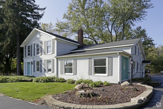
Property Record
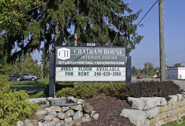
9539 Dixie Hwy, Clarkston, MI 48348

Property Detail
9539 Dixie Hwy
07-14-101-009
T4N, R8E, SEC 14 PART OF NW 1/4 BEG AT INTER OF WLY LINE US-10 HWY & E & W 1/4 LINE, TH NWLY ALG WLY LINE SAID HWY 400 FT, TH W PARA TO 1/4 LINE 400 FT, TH SELY PARA TO SAID HWY 400 FT, TH E ALG 1/4 LINE 400 FT TO BEG 3 A U201B
Officebuilding
OAKLAND
C2GEN
Michigan
B and X Area of moderate flood hazard, usually the area between the limits of the 100-year and 500-year floods.
3 AC
2024
St Clair & Lapeer Counties
2025
Detroit
126300
Detroit-Warren-Dearborn, MI
8,534 SF
NEARBY LISTINGS FOR SALE OR LEASE
DEMOGRAPHICS near 9539 Dixie Hwy
1 mile
3 mile
5 mile
2025 Total Population
2,864
16,369
40,488
2030 Population
2,904
16,807
41,596
Pop Growth 2025-2030
+ 1.40%
+ 2.68%
+ 2.74%
Average Age
43
43
43
2025 Total Households
1,089
5,939
15,467
HH Growth 2025-2030
+ 1.38%
+ 2.76%
+ 2.75%
Median Household Inc
$103,618
$118,066
$109,866
Avg Household Size
2.60
2.70
2.60
2025 Avg HH Vehicles
2.00
2.00
2.00
Median Home Value
$452,314
$393,767
$373,140
Median Year Built
1991
1990
1983
Nearby Places
Map Layers
Map Styles
 Street
 Aerial
Layers
 Traffic
 Biking
Places
Listings with unknown addresses are not visible on the map
- Restaurants
- Banks
- Shops
- Fitness
- Groceries
PUBLIC TRANSPORTATION
AIRPORT
Bishop International
Drive
Walk
Distance
Bishop International
39 min
24.2 mi
Freight Ports
Port of Toledo
Drive
Walk
Distance
Port of Toledo
114 min
88.3 mi
SALE & LEASE HISTORY
LISTING DATE
SALE/LEASE

May 23, 2019
For Lease
Nearby Properties
Address
Land Use
TOTAL SIZE
Lot Size
Zoning
Address
Land Use
TOTAL SIZE
Lot Size
Zoning
21,719 SF
26.34 AC
R2
Address
Land Use
TOTAL SIZE
Lot Size
Zoning
32,059 SF
BLL
Address
Land Use
TOTAL SIZE
Lot Size
Zoning
34,111 SF
20.14 AC
Address
Land Use
TOTAL SIZE
Lot Size
Zoning
34,807 SF
3.34 AC
OS-2
Address
Land Use
TOTAL SIZE
Lot Size
Zoning
30,726 SF
3.44 AC
R3
Address
Land Use
TOTAL SIZE
Lot Size
Zoning
6,981 SF
88.04 AC
Address
Land Use
TOTAL SIZE
Lot Size
Zoning
26,221 SF
15.76 AC
C2
Address
Land Use
TOTAL SIZE
Lot Size
Zoning
261,633 SF
1,321.20 AC
C2GEN
Address
Land Use
TOTAL SIZE
Lot Size
Zoning
44,258 SF
8.86 AC
C2GEN
Address
Land Use
TOTAL SIZE
Lot Size
Zoning
28.31 AC
R1C
Address
Land Use
TOTAL SIZE
Lot Size
Zoning
59,491 SF
6.94 AC
C2GEN
Address
Land Use
TOTAL SIZE
Lot Size
Zoning
74,592 SF
8.05 AC
RMMULT
Address
Land Use
TOTAL SIZE
Lot Size
Zoning
57,600 SF
15.72 AC
M1LITE
Address
Land Use
TOTAL SIZE
Lot Size
Zoning
28,694 SF
5.03 AC
C2GEN
Address
Land Use
TOTAL SIZE
Lot Size
Zoning
77,403 SF
4.58 AC
M1LITE
Address
Land Use
TOTAL SIZE
Lot Size
Zoning
64,195 SF
5.01 AC
M1LITE
Address
Land Use
TOTAL SIZE
Lot Size
Zoning
14,218 SF
16.94 AC
Address
Land Use
TOTAL SIZE
Lot Size
Zoning
23.56 AC
OS-2
Address
Land Use
TOTAL SIZE
Lot Size
Zoning
20,135 SF
4.54 AC
C2
Address
Land Use
TOTAL SIZE
Lot Size
Zoning
5,069 SF
2.48 AC
C-3
Address
Land Use
TOTAL SIZE
Lot Size
Zoning
13,667 SF
2.33 AC
R1
Address
Land Use
TOTAL SIZE
Lot Size
Zoning
12,226 SF
1.70 AC
O
Address
Land Use
TOTAL SIZE
Lot Size
Zoning
24.97 AC
Address
Land Use
TOTAL SIZE
Lot Size
Zoning
15,597 SF
2.24 AC
O
Address
Land Use
TOTAL SIZE
Lot Size
Zoning
16,585 SF
4 AC
R1
Address
Land Use
TOTAL SIZE
Lot Size
Zoning
19.27 AC
C2
Address
Land Use
TOTAL SIZE
Lot Size
Zoning
12,226 SF
1.70 AC
O
Address
Land Use
TOTAL SIZE
Lot Size
Zoning
4,068 SF
1.44 AC
C2
Address
Land Use
TOTAL SIZE
Lot Size
Zoning
11,526 SF
6.45 AC
BI
Address
Land Use
TOTAL SIZE
Lot Size
Zoning
31,378 SF
2.42 AC
M1LITE
The World's #1 Commercial Real Estate Marketplace
Connect with us
© 2026 CoStar Group
The information above has been obtained from sources believed reliable. While we do not doubt its accuracy we have not verified it and make no guarantee, warranty or representation about it. It is your responsibility to independently confirm its accuracy and completeness. Any projections, opinions, assumptions, or estimates used are for example only and do not represent the current or future performance of the property. The value of this transaction to you depends on tax and other factors which should be evaluated by your tax, financial, and legal advisors. You and your advisors should conduct a careful, independent investigation of the property to determine to your satisfaction the suitability of the property for your needs.