Property Record
9546 Us Highway 87 E, San Antonio, TX 78263
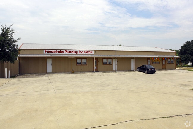

Property Detail
9546 Us Highway 87 E
San Antonio-New Braunfels, TX
CB 5137D BLK 1 LOT 1 (ADKINS SQUARE SUBD)
05137-401-0010
BEXAR
Storebuilding
Texas
B and X Area of moderate flood hazard, usually the area between the limits of the 100-year and 500-year floods.
1
2025
2 AC
2025
South
141900
San Antonio
10,454 SF
NEARBY LISTINGS FOR SALE OR LEASE
-
-
-
-
-
-
No Photo
-
View all San Antonio listings for lease on LoopNet.com
DEMOGRAPHICS near 9546 Us Highway 87 E
1 mile
3 mile
5 mile
2025 Total Population
945
5,454
22,999
2030 Population
998
5,698
24,264
Pop Growth 2025-2030
+ 5.61%
+ 4.47%
+ 5.50%
Average Age
43
43
38
2025 Total Households
345
1,986
7,638
HH Growth 2025-2030
+ 5.80%
+ 4.53%
+ 5.55%
Median Household Inc
$64,411
$74,437
$83,393
Avg Household Size
2.70
2.70
3.00
2025 Avg HH Vehicles
3.00
3.00
2.00
Median Home Value
$345,408
$343,390
$263,759
Median Year Built
1986
1987
1999
Nearby Places
Map Layers
Map Styles
 Street
 Aerial
Layers
 Traffic
 Biking
Places
Listings with unknown addresses are not visible on the map
- Restaurants
- Banks
- Shops
- Fitness
- Groceries
PUBLIC TRANSPORTATION
AIRPORT
San Antonio International
Drive
Walk
Distance
San Antonio International
28 min
20.6 mi
SALE & LEASE HISTORY
LISTING DATE
SALE/LEASE

Aug 21, 2023
For Lease
Aug 20, 2025
For Lease
Nearby Properties
Address
Land Use
TOTAL SIZE
Lot Size
Zoning
Address
Land Use
TOTAL SIZE
Lot Size
Zoning
648 SF
392.83 AC
Address
Land Use
TOTAL SIZE
Lot Size
Zoning
120,984 SF
5 AC
Address
Land Use
TOTAL SIZE
Lot Size
Zoning
61,636 SF
21.90 AC
Address
Land Use
TOTAL SIZE
Lot Size
Zoning
391,820 SF
19.13 AC
Address
Land Use
TOTAL SIZE
Lot Size
Zoning
Address
Land Use
TOTAL SIZE
Lot Size
Zoning
82,430 SF
107.10 AC
Address
Land Use
TOTAL SIZE
Lot Size
Zoning
84.86 AC
Address
Land Use
TOTAL SIZE
Lot Size
Zoning
39,892 SF
3 AC
Address
Land Use
TOTAL SIZE
Lot Size
Zoning
27,880 SF
7.38 AC
Address
Land Use
TOTAL SIZE
Lot Size
Zoning
175.05 AC
Address
Land Use
TOTAL SIZE
Lot Size
Zoning
18,960 SF
3.83 AC
Address
Land Use
TOTAL SIZE
Lot Size
Zoning
16,695 SF
3 AC
Address
Land Use
TOTAL SIZE
Lot Size
Zoning
156.02 AC
Address
Land Use
TOTAL SIZE
Lot Size
Zoning
25,440 SF
2.51 AC
Address
Land Use
TOTAL SIZE
Lot Size
Zoning
145.12 AC
Address
Land Use
TOTAL SIZE
Lot Size
Zoning
24,100 SF
6.92 AC
Address
Land Use
TOTAL SIZE
Lot Size
Zoning
1,058 SF
134.62 AC
Address
Land Use
TOTAL SIZE
Lot Size
Zoning
2,706 SF
74.50 AC
Address
Land Use
TOTAL SIZE
Lot Size
Zoning
126.06 AC
Address
Land Use
TOTAL SIZE
Lot Size
Zoning
952 SF
79.04 AC
Address
Land Use
TOTAL SIZE
Lot Size
Zoning
5,910 SF
40.74 AC
Address
Land Use
TOTAL SIZE
Lot Size
Zoning
9,800 SF
2 AC
Address
Land Use
TOTAL SIZE
Lot Size
Zoning
2,849 SF
107.47 AC
Address
Land Use
TOTAL SIZE
Lot Size
Zoning
11,020 SF
10 AC
Address
Land Use
TOTAL SIZE
Lot Size
Zoning
Address
Land Use
TOTAL SIZE
Lot Size
Zoning
Address
Land Use
TOTAL SIZE
Lot Size
Zoning
125.50 AC
Address
Land Use
TOTAL SIZE
Lot Size
Zoning
10,500 SF
1.19 AC
Address
Land Use
TOTAL SIZE
Lot Size
Zoning
93.56 AC
Address
Land Use
TOTAL SIZE
Lot Size
Zoning
67.59 AC
The World's #1 Commercial Real Estate Marketplace
Connect with us
© 2026 CoStar Group
The information above has been obtained from sources believed reliable. While we do not doubt its accuracy we have not verified it and make no guarantee, warranty or representation about it. It is your responsibility to independently confirm its accuracy and completeness. Any projections, opinions, assumptions, or estimates used are for example only and do not represent the current or future performance of the property. The value of this transaction to you depends on tax and other factors which should be evaluated by your tax, financial, and legal advisors. You and your advisors should conduct a careful, independent investigation of the property to determine to your satisfaction the suitability of the property for your needs.