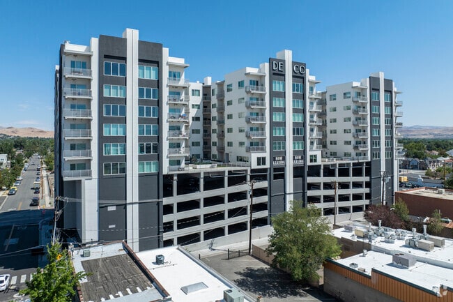
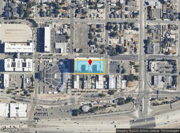
Property Record
955 Avenue Of The Oaks, Sparks, NV 89431

NEARBY LISTINGS FOR SALE OR LEASE
Property Detail
955 Avenue Of The Oaks
Reno, NV
Robison`S Addition
032-193-23
REV TM 5263 PAR A
Multifamilydwelling
Washoe
X
Nevada
32031C3045G
a
2025
1 AC
2026
Victorian Square
001904
Reno/Sparks
203,367 SF
DEMOGRAPHICS near 955 Avenue Of The Oaks
1 Mile
3 Mile
5 Mile
2024 Total Population
16,458
107,848
237,039
2029 Population
17,276
113,726
249,202
Pop Growth 2024-2029
+ 4.97%
+ 5.45%
+ 5.13%
Average Age
38
38
39
2024 Total Households
7,092
42,850
95,566
HH Growth 2024-2029
+ 5.08%
+ 5.73%
+ 5.32%
Median Household Inc
$46,001
$54,234
$59,450
Avg Household Size
2.20
2.40
2.40
2024 Avg HH Vehicles
2.00
2.00
2.00
Median Home Value
$268,571
$338,461
$390,932
Median Year Built
1974
1979
1980
Nearby Places
- Restaurants
- Banks
- Shops
- Fitness
- Groceries
PUBLIC TRANSPORTATION
COMMUTER RAIL
DRIVE
WALK
Distance
8 min
4.2 mi
AIRPORT
Reno/Tahoe International
DRIVE
WALK
Distance
Reno/Tahoe International
9 min
3.4 mi
Nearby Properties
Address
Land Use
TOTAL SIZE
Lot Size
Zoning
Address
Land Use
TOTAL SIZE
Lot Size
Zoning
2,041,608 SF
28.47 AC
MU
Address
Land Use
TOTAL SIZE
Lot Size
Zoning
762,384 SF
1,131.28 AC
MA
Address
Land Use
TOTAL SIZE
Lot Size
Zoning
1,103,124 SF
138.61 AC
MU
Address
Land Use
TOTAL SIZE
Lot Size
Zoning
1,048,514 SF
1.30 AC
MU
Address
Land Use
TOTAL SIZE
Lot Size
Zoning
385,812 SF
16.47 AC
NUD
Address
Land Use
TOTAL SIZE
Lot Size
Zoning
991,800 SF
51.03 AC
PD
Address
Land Use
TOTAL SIZE
Lot Size
Zoning
6,641 SF
247.42 AC
PF
Address
Land Use
TOTAL SIZE
Lot Size
Zoning
501,541 SF
2.89 AC
MD-ED
Address
Land Use
TOTAL SIZE
Lot Size
Zoning
294,872 SF
69.02 AC
PF
Address
Land Use
TOTAL SIZE
Lot Size
Zoning
296,048 SF
93.65 AC
PF
Address
Land Use
TOTAL SIZE
Lot Size
Zoning
356,160 SF
12.05 AC
MUD
Address
Land Use
TOTAL SIZE
Lot Size
Zoning
347,564 SF
10.23 AC
MUD
Address
Land Use
TOTAL SIZE
Lot Size
Zoning
460,688 SF
62.55 AC
PF
Address
Land Use
TOTAL SIZE
Lot Size
Zoning
342,947 SF
8.95 AC
MF30
Address
Land Use
TOTAL SIZE
Lot Size
Zoning
365,962 SF
3.54 AC
PD
Address
Land Use
TOTAL SIZE
Lot Size
Zoning
617,081 SF
2.62 AC
MUD
Address
Land Use
TOTAL SIZE
Lot Size
Zoning
366,641 SF
37.91 AC
MA
Address
Land Use
TOTAL SIZE
Lot Size
Zoning
264,533 SF
37 AC
PF
Address
Land Use
TOTAL SIZE
Lot Size
Zoning
622,628 SF
2.91 AC
MUD
Address
Land Use
TOTAL SIZE
Lot Size
Zoning
79,748 SF
8.98 AC
NUD
Address
Land Use
TOTAL SIZE
Lot Size
Zoning
231,329 SF
8.37 AC
GC
Address
Land Use
TOTAL SIZE
Lot Size
Zoning
232,481 SF
9.45 AC
PD
Address
Land Use
TOTAL SIZE
Lot Size
Zoning
273,101 SF
15.96 AC
MF-3/PUD
Address
Land Use
TOTAL SIZE
Lot Size
Zoning
249,916 SF
17.68 AC
MF30
Address
Land Use
TOTAL SIZE
Lot Size
Zoning
207,353 SF
11.32 AC
MF30
Address
Land Use
TOTAL SIZE
Lot Size
Zoning
34,503 SF
30.82 AC
PF
Address
Land Use
TOTAL SIZE
Lot Size
Zoning
242,907 SF
4.18 AC
NUD
Address
Land Use
TOTAL SIZE
Lot Size
Zoning
258,793 SF
14.86 AC
MF-3
Address
Land Use
TOTAL SIZE
Lot Size
Zoning
519,840 SF
1.08 AC
MD-RD
The World's #1 Commercial Real Estate Marketplace
Connect with us
© 2025 CoStar Group
The information above has been obtained from sources believed reliable. While we do not doubt its accuracy we have not verified it and make no guarantee, warranty or representation about it. It is your responsibility to independently confirm its accuracy and completeness. Any projections, opinions, assumptions, or estimates used are for example only and do not represent the current or future performance of the property. The value of this transaction to you depends on tax and other factors which should be evaluated by your tax, financial, and legal advisors. You and your advisors should conduct a careful, independent investigation of the property to determine to your satisfaction the suitability of the property for your needs.