Property Record
937 Stony Point Rd, Santa Rosa, CA 95407
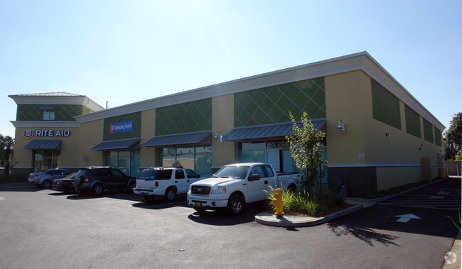


This Property Is For Sale
Current Lease Availabilities
NEARBY LISTINGS FOR SALE OR LEASE
Property Detail
937 Stony Point Rd
Santa Rosa, CA
The Lands Of Edward Michael Papola John
035-121-059
2016 FM REM 035-121-058 LLA SANTA ROSA
Regionalshoppingcenterormallwithanchorstore
Sonoma
X
California
06097C0736F
0.82 AC
2024
Santa Rosa
2025
North Bay/Santa Rosa
153201
DEMOGRAPHICS near 937 Stony Point Rd
1 Mile
3 Mile
5 Mile
2024 Total Population
20,452
120,334
188,981
2029 Population
20,218
118,964
187,241
Pop Growth 2024-2029
(1.14%)
(1.14%)
(0.92%)
Average Age
38
39
41
2024 Total Households
6,618
42,025
69,043
HH Growth 2024-2029
(1.15%)
(1.14%)
(0.89%)
Median Household Inc
$74,388
$79,677
$90,369
Avg Household Size
3.00
2.70
2.60
2024 Avg HH Vehicles
2.00
2.00
2.00
Median Home Value
$569,715
$649,859
$714,844
Median Year Built
1980
1980
1979
Nearby Places
Map Layers
Map Styles
 Street
 Aerial
- Restaurants
- Banks
- Shops
- Fitness
- Groceries
PUBLIC TRANSPORTATION
COMMUTER RAIL
Santa Rosa Downtown Smart (Main Line - Sonoma Marin Area Rail Transit)
DRIVE
WALK
Distance
Santa Rosa Downtown Smart (Main Line - Sonoma Marin Area Rail Transit)
5 min
2.0 mi
Santa Rosa North Smart (Main Line - Sonoma Marin Area Rail Transit)
DRIVE
WALK
Distance
Santa Rosa North Smart (Main Line - Sonoma Marin Area Rail Transit)
7 min
3.3 mi
AIRPORT
Charles M Schulz - Sonoma County
DRIVE
WALK
Distance
Charles M Schulz - Sonoma County
16 min
10.0 mi
Freight Ports
Port of Richmond
DRIVE
WALK
Distance
Port of Richmond
64 min
48.9 mi
Nearby Properties
Address
Land Use
TOTAL SIZE
Lot Size
Zoning
Address
Land Use
TOTAL SIZE
Lot Size
Zoning
258,134 SF
7.42 AC
CITYSR
Address
Land Use
TOTAL SIZE
Lot Size
Zoning
285,160 SF
8.23 AC
Address
Land Use
TOTAL SIZE
Lot Size
Zoning
249,210 SF
22.98 AC
C-2
Address
Land Use
TOTAL SIZE
Lot Size
Zoning
441,698 SF
10.23 AC
C2
Address
Land Use
TOTAL SIZE
Lot Size
Zoning
222,278 SF
13.39 AC
CITYSR
Address
Land Use
TOTAL SIZE
Lot Size
Zoning
92,480 SF
33.80 AC
Address
Land Use
TOTAL SIZE
Lot Size
Zoning
447,600 SF
22.01 AC
Address
Land Use
TOTAL SIZE
Lot Size
Zoning
203,119 SF
9.35 AC
Address
Land Use
TOTAL SIZE
Lot Size
Zoning
167,485 SF
7.81 AC
Address
Land Use
TOTAL SIZE
Lot Size
Zoning
260,417 SF
9.13 AC
CITYSR
Address
Land Use
TOTAL SIZE
Lot Size
Zoning
74,000 SF
0.51 AC
Address
Land Use
TOTAL SIZE
Lot Size
Zoning
116,188 SF
6.55 AC
CITYSR
Address
Land Use
TOTAL SIZE
Lot Size
Zoning
8.06 AC
Address
Land Use
TOTAL SIZE
Lot Size
Zoning
136,609 SF
9.33 AC
CITYSR
Address
Land Use
TOTAL SIZE
Lot Size
Zoning
90,079 SF
3.09 AC
Address
Land Use
TOTAL SIZE
Lot Size
Zoning
9,450 SF
0.76 AC
Address
Land Use
TOTAL SIZE
Lot Size
Zoning
142,297 SF
4.65 AC
Address
Land Use
TOTAL SIZE
Lot Size
Zoning
107,765 SF
5.70 AC
CITYSR
Address
Land Use
TOTAL SIZE
Lot Size
Zoning
105,696 SF
5.46 AC
Address
Land Use
TOTAL SIZE
Lot Size
Zoning
87,300 SF
6.64 AC
Address
Land Use
TOTAL SIZE
Lot Size
Zoning
71,800 SF
7.76 AC
CIPD
Address
Land Use
TOTAL SIZE
Lot Size
Zoning
87,750 SF
5.43 AC
Address
Land Use
TOTAL SIZE
Lot Size
Zoning
82,215 SF
7.91 AC
C2
Address
Land Use
TOTAL SIZE
Lot Size
Zoning
146,611 SF
9.44 AC
Address
Land Use
TOTAL SIZE
Lot Size
Zoning
49,077 SF
7.09 AC
R210
Address
Land Use
TOTAL SIZE
Lot Size
Zoning
85,920 SF
5.69 AC
CITYSR
Address
Land Use
TOTAL SIZE
Lot Size
Zoning
205,776 SF
9.96 AC
CITYSR
Address
Land Use
TOTAL SIZE
Lot Size
Zoning
111,261 SF
7.37 AC
C4
Address
Land Use
TOTAL SIZE
Lot Size
Zoning
142,272 SF
0.25 AC
C2
Address
Land Use
TOTAL SIZE
Lot Size
Zoning
95,238 SF
4.96 AC
CITYSR
The World's #1 Commercial Real Estate Marketplace
Connect with us
© 2025 CoStar Group
The information above has been obtained from sources believed reliable. While we do not doubt its accuracy we have not verified it and make no guarantee, warranty or representation about it. It is your responsibility to independently confirm its accuracy and completeness. Any projections, opinions, assumptions, or estimates used are for example only and do not represent the current or future performance of the property. The value of this transaction to you depends on tax and other factors which should be evaluated by your tax, financial, and legal advisors. You and your advisors should conduct a careful, independent investigation of the property to determine to your satisfaction the suitability of the property for your needs.