Property Record
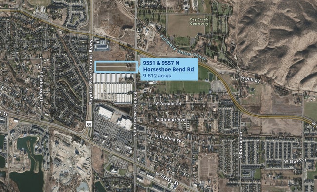
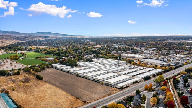
9551 N Horseshoe Bend Rd, Eagle, ID 83616
NEARBY LISTINGS FOR SALE OR LEASE
Property Detail
9551 N Horseshoe Bend Rd
S0515110250
PAR #0220 NEAR N SIDE NE4NE4 SEC 15 4N 1E PARCEL A R/S 5735 #110200-S
Agriculturalland
Ada
X
Idaho
16001C0154J
5 AC
2024
Eagle
2025
Boise City/Nampa
010232
Boise City, ID
DEMOGRAPHICS near 9551 N Horseshoe Bend Rd
1 Mile
3 Mile
5 Mile
2024 Total Population
6,347
48,943
143,844
2029 Population
7,191
54,975
160,598
Pop Growth 2024-2029
+ 13.30%
+ 12.32%
+ 11.65%
Average Age
44
45
42
2024 Total Households
2,543
19,614
55,208
HH Growth 2024-2029
+ 13.65%
+ 12.66%
+ 11.95%
Median Household Inc
$74,136
$88,200
$84,630
Avg Household Size
2.40
2.40
2.50
2024 Avg HH Vehicles
2.00
2.00
2.00
Median Home Value
$468,260
$482,515
$469,939
Median Year Built
1999
1996
1996
Nearby Places
- Restaurants
- Banks
- Shops
- Fitness
- Groceries
PUBLIC TRANSPORTATION
AIRPORT
Boise Air Trml/Gowen Field
DRIVE
WALK
Distance
Boise Air Trml/Gowen Field
39 min
16.1 mi
Freight Ports
Port of Portland
DRIVE
WALK
Distance
Port of Portland
475 min
426.7 mi
SALE & LEASE HISTORY
LISTING DATE
SALE/LEASE

Oct 17, 2024
For Sale
Nearby Properties
Address
Land Use
TOTAL SIZE
Lot Size
Zoning
Address
Land Use
TOTAL SIZE
Lot Size
Zoning
386,225 SF
13.46 AC
ZC-270
Address
Land Use
TOTAL SIZE
Lot Size
Zoning
301,800 SF
12.70 AC
R-3
Address
Land Use
TOTAL SIZE
Lot Size
Zoning
239,991 SF
8.09 AC
MU-DA
Address
Land Use
TOTAL SIZE
Lot Size
Zoning
216,950 SF
9.03 AC
R-3
Address
Land Use
TOTAL SIZE
Lot Size
Zoning
150,584 SF
6.77 AC
M
Address
Land Use
TOTAL SIZE
Lot Size
Zoning
203,635 SF
4.76 AC
ZC-245
Address
Land Use
TOTAL SIZE
Lot Size
Zoning
167,603 SF
6.60 AC
C-2DA
Address
Land Use
TOTAL SIZE
Lot Size
Zoning
98,738 SF
4.25 AC
CBD
Address
Land Use
TOTAL SIZE
Lot Size
Zoning
151,365 SF
12.03 AC
ZC-243
Address
Land Use
TOTAL SIZE
Lot Size
Zoning
129,827 SF
3.08 AC
MU-DA
Address
Land Use
TOTAL SIZE
Lot Size
Zoning
124,286 SF
5 AC
R-3
Address
Land Use
TOTAL SIZE
Lot Size
Zoning
102,272 SF
7.18 AC
R-20
Address
Land Use
TOTAL SIZE
Lot Size
Zoning
152,123 SF
6 AC
MU-DA
Address
Land Use
TOTAL SIZE
Lot Size
Zoning
69,546 SF
4.26 AC
MU-DA
Address
Land Use
TOTAL SIZE
Lot Size
Zoning
65,034 SF
4.44 AC
MU-DA
Address
Land Use
TOTAL SIZE
Lot Size
Zoning
204,033 SF
12.88 AC
C-1
Address
Land Use
TOTAL SIZE
Lot Size
Zoning
98,612 SF
5.38 AC
MU-DA
Address
Land Use
TOTAL SIZE
Lot Size
Zoning
97,655 SF
7.74 AC
ZC-243
Address
Land Use
TOTAL SIZE
Lot Size
Zoning
36,454 SF
3.18 AC
MU
Address
Land Use
TOTAL SIZE
Lot Size
Zoning
81,591 SF
2.88 AC
MU-DA
Address
Land Use
TOTAL SIZE
Lot Size
Zoning
165,295 SF
7.01 AC
MU-DA
Address
Land Use
TOTAL SIZE
Lot Size
Zoning
123,324 SF
2.22 AC
R-3
Address
Land Use
TOTAL SIZE
Lot Size
Zoning
66,322 SF
3.61 AC
ZC-243
Address
Land Use
TOTAL SIZE
Lot Size
Zoning
80,722 SF
4.59 AC
ZC-243
Address
Land Use
TOTAL SIZE
Lot Size
Zoning
59,778 SF
3.68 AC
C-3-DA
Address
Land Use
TOTAL SIZE
Lot Size
Zoning
125,400 SF
12.68 AC
ZC-243
Address
Land Use
TOTAL SIZE
Lot Size
Zoning
68,707 SF
2.83 AC
C-3-DA
Address
Land Use
TOTAL SIZE
Lot Size
Zoning
105,312 SF
3.85 AC
ZC-268
Address
Land Use
TOTAL SIZE
Lot Size
Zoning
74,296 SF
4.86 AC
CBD
Address
Land Use
TOTAL SIZE
Lot Size
Zoning
30,144 SF
22.20 AC
R-3
The World's #1 Commercial Real Estate Marketplace
Connect with us
© 2025 CoStar Group
The information above has been obtained from sources believed reliable. While we do not doubt its accuracy we have not verified it and make no guarantee, warranty or representation about it. It is your responsibility to independently confirm its accuracy and completeness. Any projections, opinions, assumptions, or estimates used are for example only and do not represent the current or future performance of the property. The value of this transaction to you depends on tax and other factors which should be evaluated by your tax, financial, and legal advisors. You and your advisors should conduct a careful, independent investigation of the property to determine to your satisfaction the suitability of the property for your needs.