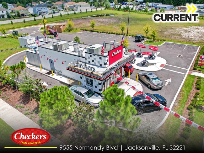
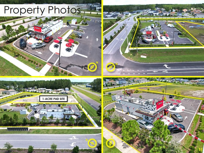
Property Record
9555 Normandy Blvd, Jacksonville, FL 32221


Property Detail
9555 Normandy Blvd
009067-0015
5-93 32-2S-25E 1.97 JACKSONVILLE HEIGHTS PT TRACT 1 BLK 4, PT TRACT 7, 8 BLK 3 OF SEC 33, PT CLOSED RW RECD O/R 20249-1895
Miscellaneous
DUVAL
PUD
Florida
2025
1.98 AC
2026
Riverside
011905
Jacksonville (Florida)
1,120 SF
Jacksonville, FL
NEARBY LISTINGS FOR SALE OR LEASE
-
-
View all Jacksonville listings for sale on LoopNet.com
DEMOGRAPHICS near 9555 Normandy Blvd
1 mile
3 mile
5 mile
2025 Total Population
5,607
57,761
131,490
2030 Population
5,958
61,369
140,087
Pop Growth 2025-2030
+ 6.26%
+ 6.25%
+ 6.54%
Average Age
36
38
38
2025 Total Households
1,917
20,586
48,661
HH Growth 2025-2030
+ 6.47%
+ 6.46%
+ 6.81%
Median Household Inc
$78,685
$74,248
$66,358
Avg Household Size
2.90
2.70
2.60
2025 Avg HH Vehicles
2.00
2.00
2.00
Median Home Value
$279,227
$275,522
$257,343
Median Year Built
2000
1997
1989
Nearby Places
Map Layers
Map Styles
 Street
 Aerial
Transit
 Traffic
 Biking
Places
Listings with unknown addresses are not visible on the map
- Restaurants
- Banks
- Shops
- Fitness
- Groceries
PUBLIC TRANSPORTATION
AIRPORT
Jacksonville International
Drive
Walk
Distance
Jacksonville International
34 min
22.0 mi
Freight Ports
Jacksonville Port
Drive
Walk
Distance
Jacksonville Port
26 min
15.2 mi
SALE & LEASE HISTORY
LISTING DATE
SALE/LEASE

Oct 21, 2025
For Sale
Nearby Properties
Address
Land Use
TOTAL SIZE
Lot Size
Zoning
Address
Land Use
TOTAL SIZE
Lot Size
Zoning
239,891 SF
21.95 AC
CRO
Address
Land Use
TOTAL SIZE
Lot Size
Zoning
185,662 SF
1,416.80 AC
PBF-3
Address
Land Use
TOTAL SIZE
Lot Size
Zoning
321,547 SF
17.17 AC
PUD
Address
Land Use
TOTAL SIZE
Lot Size
Zoning
221,429 SF
15.42 AC
PUD
Address
Land Use
TOTAL SIZE
Lot Size
Zoning
307,960 SF
18.52 AC
PUD
Address
Land Use
TOTAL SIZE
Lot Size
Zoning
375,127 SF
18.65 AC
PUD
Address
Land Use
TOTAL SIZE
Lot Size
Zoning
505,748 SF
94.71 AC
IL
Address
Land Use
TOTAL SIZE
Lot Size
Zoning
509,686 SF
43.32 AC
IL
Address
Land Use
TOTAL SIZE
Lot Size
Zoning
139,435 SF
7.15 AC
CCG-2
Address
Land Use
TOTAL SIZE
Lot Size
Zoning
481,686 SF
43.54 AC
IL
Address
Land Use
TOTAL SIZE
Lot Size
Zoning
64,013 SF
8.37 AC
PUD
Address
Land Use
TOTAL SIZE
Lot Size
Zoning
88,000 SF
11.28 AC
CCG-1
Address
Land Use
TOTAL SIZE
Lot Size
Zoning
269,178 SF
129.93 AC
PBF-2
Address
Land Use
TOTAL SIZE
Lot Size
Zoning
136,599 SF
47.95 AC
PBF-2
Address
Land Use
TOTAL SIZE
Lot Size
Zoning
75,247 SF
14.90 AC
CCG-1
Address
Land Use
TOTAL SIZE
Lot Size
Zoning
65,052 SF
15.97 AC
PUD
Address
Land Use
TOTAL SIZE
Lot Size
Zoning
30,789 SF
2.10 AC
PUD
Address
Land Use
TOTAL SIZE
Lot Size
Zoning
197,792 SF
17.56 AC
RMD-D
Address
Land Use
TOTAL SIZE
Lot Size
Zoning
160,778 SF
25.46 AC
IL
Address
Land Use
TOTAL SIZE
Lot Size
Zoning
98,541 SF
8.68 AC
CCG-2
Address
Land Use
TOTAL SIZE
Lot Size
Zoning
108,217 SF
178.52 AC
PBF-1
Address
Land Use
TOTAL SIZE
Lot Size
Zoning
131,247 SF
5.68 AC
PBF-2
Address
Land Use
TOTAL SIZE
Lot Size
Zoning
6,792 SF
53.56 AC
PUD
Address
Land Use
TOTAL SIZE
Lot Size
Zoning
80,512 SF
4.05 AC
PUD
Address
Land Use
TOTAL SIZE
Lot Size
Zoning
153,549 SF
15.96 AC
PBF-1
Address
Land Use
TOTAL SIZE
Lot Size
Zoning
29,022 SF
3.17 AC
PUD
Address
Land Use
TOTAL SIZE
Lot Size
Zoning
66,892 SF
9.62 AC
PUD
Address
Land Use
TOTAL SIZE
Lot Size
Zoning
33,424 SF
2.97 AC
PUD
Address
Land Use
TOTAL SIZE
Lot Size
Zoning
89,759 SF
7.05 AC
RMD-D
Address
Land Use
TOTAL SIZE
Lot Size
Zoning
53,527 SF
10.89 AC
CCG-1
The World's #1 Commercial Real Estate Marketplace
Connect with us
© 2026 CoStar Group
The information above has been obtained from sources believed reliable. While we do not doubt its accuracy we have not verified it and make no guarantee, warranty or representation about it. It is your responsibility to independently confirm its accuracy and completeness. Any projections, opinions, assumptions, or estimates used are for example only and do not represent the current or future performance of the property. The value of this transaction to you depends on tax and other factors which should be evaluated by your tax, financial, and legal advisors. You and your advisors should conduct a careful, independent investigation of the property to determine to your satisfaction the suitability of the property for your needs.