Property Record
9558 Twenty Mile Rd, Parker, CO 80134


Property Detail
9558 Twenty Mile Rd
Denver-Aurora-Centennial, CO
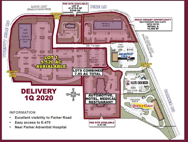
LOT 1-A PARKER AND PINE 1 AMD 1 1.675 AM/L
2233-103-10-028
DOUGLAS
Commercialnec
Colorado
2024
1-a
2025
1.68 AC
014010
Southeast
3,887 SF
Denver
NEARBY LISTINGS FOR SALE OR LEASE
DEMOGRAPHICS near 9558 Twenty Mile Rd
1 mile
3 mile
5 mile
2025 Total Population
6,352
71,034
162,903
2030 Population
6,892
76,189
172,133
Pop Growth 2025-2030
+ 8.50%
+ 7.26%
+ 5.67%
Average Age
38
38
39
2025 Total Households
2,934
26,429
59,045
HH Growth 2025-2030
+ 8.86%
+ 7.57%
+ 5.94%
Median Household Inc
$83,700
$119,441
$129,645
Avg Household Size
2.10
2.60
2.70
2025 Avg HH Vehicles
2.00
2.00
2.00
Median Home Value
$531,477
$698,988
$721,119
Median Year Built
2005
2002
2004
Nearby Places
Map Layers
Map Styles
 Street
 Aerial
Layers
 Traffic
 Biking
Places
Listings with unknown addresses are not visible on the map
- Restaurants
- Banks
- Shops
- Fitness
- Groceries
PUBLIC TRANSPORTATION
AIRPORT
Denver International
Drive
Walk
Distance
Denver International
31 min
28.8 mi
Freight Ports
Tulsa Port Of Catoosa
Drive
Walk
Distance
Tulsa Port Of Catoosa
724 min
708.7 mi
SALE & LEASE HISTORY
LISTING DATE
SALE/LEASE

Sep 30, 2020
For Lease
Mar 23, 2022
For Sale
Jun 06, 2017
For Lease
Nearby Properties
Address
Land Use
TOTAL SIZE
Lot Size
Zoning
Address
Land Use
TOTAL SIZE
Lot Size
Zoning
381,657 SF
33.84 AC
Address
Land Use
TOTAL SIZE
Lot Size
Zoning
304,620 SF
23.95 AC
AMU
Address
Land Use
TOTAL SIZE
Lot Size
Zoning
494,489 SF
22.16 AC
Address
Land Use
TOTAL SIZE
Lot Size
Zoning
207,872 SF
44.94 AC
PDU
Address
Land Use
TOTAL SIZE
Lot Size
Zoning
140,080 SF
15.05 AC
Address
Land Use
TOTAL SIZE
Lot Size
Zoning
343,018 SF
15.13 AC
Address
Land Use
TOTAL SIZE
Lot Size
Zoning
344,128 SF
19.06 AC
Address
Land Use
TOTAL SIZE
Lot Size
Zoning
455,049 SF
16.96 AC
Address
Land Use
TOTAL SIZE
Lot Size
Zoning
132,601 SF
16.08 AC
Address
Land Use
TOTAL SIZE
Lot Size
Zoning
93,100 SF
8.78 AC
Address
Land Use
TOTAL SIZE
Lot Size
Zoning
442,567 SF
16.91 AC
Address
Land Use
TOTAL SIZE
Lot Size
Zoning
453,901 SF
16.34 AC
Address
Land Use
TOTAL SIZE
Lot Size
Zoning
445,938 SF
19.85 AC
Address
Land Use
TOTAL SIZE
Lot Size
Zoning
53,500 SF
6 AC
Address
Land Use
TOTAL SIZE
Lot Size
Zoning
375,171 SF
12.88 AC
Address
Land Use
TOTAL SIZE
Lot Size
Zoning
337,565 SF
17.11 AC
Address
Land Use
TOTAL SIZE
Lot Size
Zoning
569,400 SF
42.82 AC
PDU
Address
Land Use
TOTAL SIZE
Lot Size
Zoning
514,882 SF
18.63 AC
Address
Land Use
TOTAL SIZE
Lot Size
Zoning
389,337 SF
22.01 AC
Address
Land Use
TOTAL SIZE
Lot Size
Zoning
93,100 SF
8.95 AC
Address
Land Use
TOTAL SIZE
Lot Size
Zoning
113,010 SF
21.48 AC
AMU
Address
Land Use
TOTAL SIZE
Lot Size
Zoning
132,601 SF
16.05 AC
Address
Land Use
TOTAL SIZE
Lot Size
Zoning
369,624 SF
21.98 AC
Address
Land Use
TOTAL SIZE
Lot Size
Zoning
307,904 SF
15.72 AC
Address
Land Use
TOTAL SIZE
Lot Size
Zoning
88,280 SF
34.08 AC
A1
Address
Land Use
TOTAL SIZE
Lot Size
Zoning
138,348 SF
14.96 AC
RR
Address
Land Use
TOTAL SIZE
Lot Size
Zoning
143,290 SF
7.99 AC
Address
Land Use
TOTAL SIZE
Lot Size
Zoning
147,550 SF
8.35 AC
PDU
Address
Land Use
TOTAL SIZE
Lot Size
Zoning
54,900 SF
7.21 AC
Address
Land Use
TOTAL SIZE
Lot Size
Zoning
117,593 SF
37.91 AC
A1
The World's #1 Commercial Real Estate Marketplace
Connect with us
© 2026 CoStar Group
The information above has been obtained from sources believed reliable. While we do not doubt its accuracy we have not verified it and make no guarantee, warranty or representation about it. It is your responsibility to independently confirm its accuracy and completeness. Any projections, opinions, assumptions, or estimates used are for example only and do not represent the current or future performance of the property. The value of this transaction to you depends on tax and other factors which should be evaluated by your tax, financial, and legal advisors. You and your advisors should conduct a careful, independent investigation of the property to determine to your satisfaction the suitability of the property for your needs.