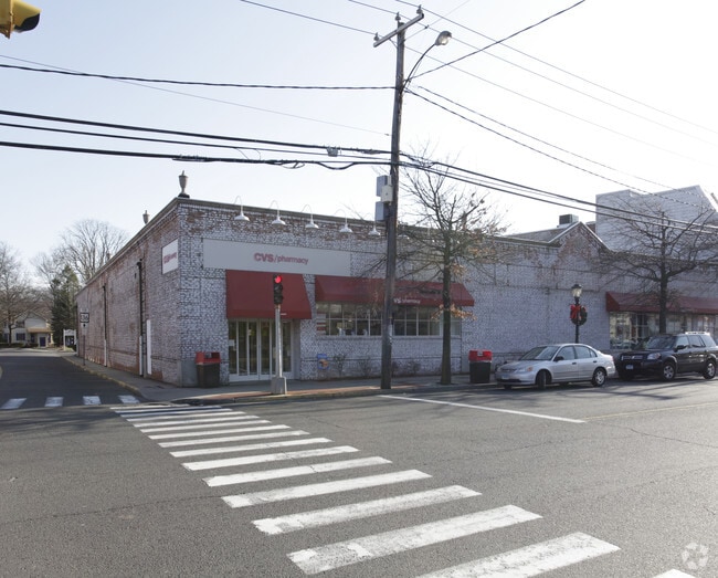
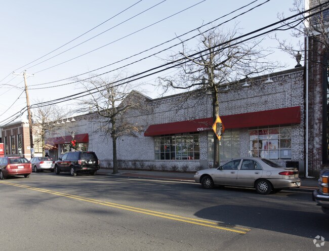
Property Record
956 Post Rd, Darien, CT 06820

Property Detail
956 Post Rd
Storebuilding
FAIRFIELD
CBD
Connecticut
B and X Area of moderate flood hazard, usually the area between the limits of the 100-year and 500-year floods.
0.31 AC
2025
Darien
2025
Westchester/So Connecticut
030500
Bridgeport-Stamford-Danbury, CT
26,530 SF
DARI-000072-000000-000004
NEARBY LISTINGS FOR SALE OR LEASE
DEMOGRAPHICS near 956 Post Rd
1 mile
3 mile
5 mile
2025 Total Population
6,263
74,553
225,939
2030 Population
6,519
76,113
231,098
Pop Growth 2025-2030
+ 4.09%
+ 2.09%
+ 2.28%
Average Age
40
40
40
2025 Total Households
2,072
26,599
87,948
HH Growth 2025-2030
+ 4.05%
+ 2.00%
+ 2.45%
Median Household Inc
$249,455
$120,648
$111,464
Avg Household Size
3.00
2.70
2.50
2025 Avg HH Vehicles
2.00
2.00
2.00
Median Home Value
$1,110,526
$835,042
$718,898
Median Year Built
1957
1962
1968
Nearby Places
Map Layers
Map Styles
 Street
 Aerial
Transit
 Traffic
 Biking
Places
Listings with unknown addresses are not visible on the map
- Restaurants
- Banks
- Shops
- Fitness
- Groceries
PUBLIC TRANSPORTATION
COMMUTER RAIL
Darien Station (New Haven Line - Metro-North Commuter Railroad Company (Metro-North))
Drive
Walk
Distance
Darien Station (New Haven Line - Metro-North Commuter Railroad Company (Metro-North))
3 min
12 min
0.6 mi
Rowayton Station (New Haven Line - Metro-North Commuter Railroad Company (Metro-North))
Drive
Walk
Distance
Rowayton Station (New Haven Line - Metro-North Commuter Railroad Company (Metro-North))
8 min
1.9 mi
AIRPORT
Westchester County
Drive
Walk
Distance
Westchester County
29 min
23.1 mi
LaGuardia
Drive
Walk
Distance
LaGuardia
47 min
37.1 mi
John F Kennedy International
Drive
Walk
Distance
John F Kennedy International
54 min
44.3 mi
Nearby Properties
Address
Land Use
TOTAL SIZE
Lot Size
Zoning
Address
Land Use
TOTAL SIZE
Lot Size
Zoning
8.91 AC
DC
Address
Land Use
TOTAL SIZE
Lot Size
Zoning
336,000 SF
40 AC
MU
Address
Land Use
TOTAL SIZE
Lot Size
Zoning
32.68 AC
MD
Address
Land Use
TOTAL SIZE
Lot Size
Zoning
32.06 AC
DMR
Address
Land Use
TOTAL SIZE
Lot Size
Zoning
42.18 AC
P
Address
Land Use
TOTAL SIZE
Lot Size
Zoning
124,373 SF
13.87 AC
A2
Address
Land Use
TOTAL SIZE
Lot Size
Zoning
17 AC
A2
Address
Land Use
TOTAL SIZE
Lot Size
Zoning
107,227 SF
12.89 AC
MD
Address
Land Use
TOTAL SIZE
Lot Size
Zoning
45.90 AC
R-1
Address
Land Use
TOTAL SIZE
Lot Size
Zoning
130,394 SF
28.72 AC
B
Address
Land Use
TOTAL SIZE
Lot Size
Zoning
171,335 SF
25.94 AC
MU
Address
Land Use
TOTAL SIZE
Lot Size
Zoning
58,269 SF
9.86 AC
MU
Address
Land Use
TOTAL SIZE
Lot Size
Zoning
9.76 AC
B1
Address
Land Use
TOTAL SIZE
Lot Size
Zoning
132,185 SF
3.99 AC
DO
Address
Land Use
TOTAL SIZE
Lot Size
Zoning
141,174 SF
10.75 AC
B2
Address
Land Use
TOTAL SIZE
Lot Size
Zoning
119,531 SF
17.92 AC
D
Address
Land Use
TOTAL SIZE
Lot Size
Zoning
40.41 AC
P
Address
Land Use
TOTAL SIZE
Lot Size
Zoning
12.71 AC
B2
Address
Land Use
TOTAL SIZE
Lot Size
Zoning
10.53 AC
B2
Address
Land Use
TOTAL SIZE
Lot Size
Zoning
9.60 AC
MU
Address
Land Use
TOTAL SIZE
Lot Size
Zoning
9.75 AC
B2
Address
Land Use
TOTAL SIZE
Lot Size
Zoning
96,563 SF
9.49 AC
DC
Address
Land Use
TOTAL SIZE
Lot Size
Zoning
24,704 SF
1.52 AC
I1
Address
Land Use
TOTAL SIZE
Lot Size
Zoning
133,560 SF
2.30 AC
I1
Address
Land Use
TOTAL SIZE
Lot Size
Zoning
84,515 SF
16.31 AC
MU
Address
Land Use
TOTAL SIZE
Lot Size
Zoning
72,796 SF
8.30 AC
MU
Address
Land Use
TOTAL SIZE
Lot Size
Zoning
16.96 AC
R20
Address
Land Use
TOTAL SIZE
Lot Size
Zoning
11.84 AC
B2
Address
Land Use
TOTAL SIZE
Lot Size
Zoning
166,834 SF
9.47 AC
ML
Address
Land Use
TOTAL SIZE
Lot Size
Zoning
3.96 AC
DC
The World's #1 Commercial Real Estate Marketplace
Connect with us
© 2026 CoStar Group
The information above has been obtained from sources believed reliable. While we do not doubt its accuracy we have not verified it and make no guarantee, warranty or representation about it. It is your responsibility to independently confirm its accuracy and completeness. Any projections, opinions, assumptions, or estimates used are for example only and do not represent the current or future performance of the property. The value of this transaction to you depends on tax and other factors which should be evaluated by your tax, financial, and legal advisors. You and your advisors should conduct a careful, independent investigation of the property to determine to your satisfaction the suitability of the property for your needs.