Property Record
9570 S Gardenia St, Pahrump, NV 89048


NEARBY LISTINGS FOR SALE OR LEASE
-
-
View all Pahrump listings for sale on LoopNet.com
Property Detail
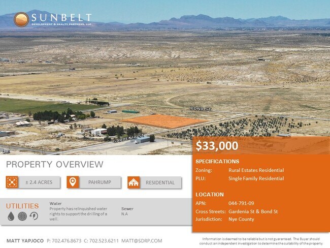
9570 S Gardenia St
Pahrump, NV
Homestead Gardens
44-791-09
T21S R53E S36 B.4 L.2 HOMESTEAD GARDENS
Residentialacreage
Nye
X
Nevada
32023C8905G
2
2024
2.40 AC
2025
Carson City/Nevada Area
960408
Other Market Areas
DEMOGRAPHICS near 9570 S Gardenia St
1 Mile
3 Mile
5 Mile
2024 Total Population
449
2,874
10,929
2029 Population
521
3,347
12,887
Pop Growth 2024-2029
+ 16.04%
+ 16.46%
+ 17.92%
Average Age
49
47
49
2024 Total Households
185
1,145
4,533
HH Growth 2024-2029
+ 15.68%
+ 16.51%
+ 17.98%
Median Household Inc
$61,956
$55,792
$64,858
Avg Household Size
2.30
2.30
2.30
2024 Avg HH Vehicles
2.00
2.00
2.00
Median Home Value
$238,983
$218,318
$276,138
Median Year Built
1992
1994
1997
Nearby Places
Map Layers
Map Styles
 Street
 Aerial
- Restaurants
- Banks
- Shops
- Fitness
- Groceries
SALE & LEASE HISTORY
LISTING DATE
SALE/LEASE

Mar 02, 2020
For Sale
Aug 06, 2020
For Sale
Nearby Properties
Address
Land Use
TOTAL SIZE
Lot Size
Zoning
Address
Land Use
TOTAL SIZE
Lot Size
Zoning
2,385.88 AC
R
Address
Land Use
TOTAL SIZE
Lot Size
Zoning
1,372.49 AC
R
Address
Land Use
TOTAL SIZE
Lot Size
Zoning
1,784.91 AC
R
Address
Land Use
TOTAL SIZE
Lot Size
Zoning
648 AC
R
Address
Land Use
TOTAL SIZE
Lot Size
Zoning
18,650 SF
20 AC
BR
Address
Land Use
TOTAL SIZE
Lot Size
Zoning
400 AC
R
Address
Land Use
TOTAL SIZE
Lot Size
Zoning
275 AC
R
Address
Land Use
TOTAL SIZE
Lot Size
Zoning
286.91 AC
SPLIT
Address
Land Use
TOTAL SIZE
Lot Size
Zoning
4,671 SF
20.68 AC
BR
Address
Land Use
TOTAL SIZE
Lot Size
Zoning
156.91 AC
R
Address
Land Use
TOTAL SIZE
Lot Size
Zoning
450.44 AC
R
Address
Land Use
TOTAL SIZE
Lot Size
Zoning
24,192 SF
8.09 AC
BO
Address
Land Use
TOTAL SIZE
Lot Size
Zoning
202.52 AC
R
Address
Land Use
TOTAL SIZE
Lot Size
Zoning
7,135 SF
2.20 AC
RE-2
Address
Land Use
TOTAL SIZE
Lot Size
Zoning
5,563 SF
4.32 AC
RH-4.5
Address
Land Use
TOTAL SIZE
Lot Size
Zoning
3,040 SF
37.12 AC
CF
Address
Land Use
TOTAL SIZE
Lot Size
Zoning
21.98 AC
GC
Address
Land Use
TOTAL SIZE
Lot Size
Zoning
2,800 SF
5.65 AC
GC
Address
Land Use
TOTAL SIZE
Lot Size
Zoning
2,032 SF
1.10 AC
RE-1
Address
Land Use
TOTAL SIZE
Lot Size
Zoning
3,049 SF
1.10 AC
RE-1
Address
Land Use
TOTAL SIZE
Lot Size
Zoning
4,554 SF
1.10 AC
RE-1
Address
Land Use
TOTAL SIZE
Lot Size
Zoning
2,000 SF
1.10 AC
NC
Address
Land Use
TOTAL SIZE
Lot Size
Zoning
1,593 SF
1.40 AC
RE-1
Address
Land Use
TOTAL SIZE
Lot Size
Zoning
4,680 SF
13.82 AC
BO
Address
Land Use
TOTAL SIZE
Lot Size
Zoning
1,540 SF
1.10 AC
NC
Address
Land Use
TOTAL SIZE
Lot Size
Zoning
8.83 AC
GC
Address
Land Use
TOTAL SIZE
Lot Size
Zoning
5,000 SF
1.10 AC
RE-1
Address
Land Use
TOTAL SIZE
Lot Size
Zoning
1,856 SF
2.50 AC
RE-2
Address
Land Use
TOTAL SIZE
Lot Size
Zoning
352 SF
2.50 AC
RE-1
Address
Land Use
TOTAL SIZE
Lot Size
Zoning
1,316 SF
1.10 AC
The World's #1 Commercial Real Estate Marketplace
Connect with us
© 2026 CoStar Group
The information above has been obtained from sources believed reliable. While we do not doubt its accuracy we have not verified it and make no guarantee, warranty or representation about it. It is your responsibility to independently confirm its accuracy and completeness. Any projections, opinions, assumptions, or estimates used are for example only and do not represent the current or future performance of the property. The value of this transaction to you depends on tax and other factors which should be evaluated by your tax, financial, and legal advisors. You and your advisors should conduct a careful, independent investigation of the property to determine to your satisfaction the suitability of the property for your needs.