Property Record
958 Nw 6Th St, Redmond, OR 97756
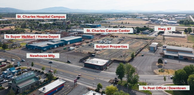

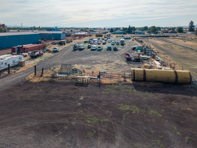
This Property Is For Sale
Property Detail
958 Nw 6Th St
122309
DESCHUTES
Commercialacreage
Oregon
C2
2.31 AC
B and X Area of moderate flood hazard, usually the area between the limits of the 100-year and 500-year floods.
Deschutes County
2025
Portland
2025
Bend, OR
000902
NEARBY LISTINGS FOR SALE OR LEASE
DEMOGRAPHICS near 958 Nw 6Th St
1 mile
3 mile
5 mile
2025 Total Population
8,010
31,629
40,683
2030 Population
8,190
32,403
41,694
Pop Growth 2025-2030
+ 2.25%
+ 2.45%
+ 2.49%
Average Age
40
39
41
2025 Total Households
3,035
11,882
15,557
HH Growth 2025-2030
+ 2.17%
+ 2.41%
+ 2.48%
Median Household Inc
$86,082
$89,284
$91,713
Avg Household Size
2.60
2.60
2.60
2025 Avg HH Vehicles
2.00
2.00
2.00
Median Home Value
$460,640
$483,445
$551,662
Median Year Built
1995
2000
1999
Nearby Places
Map Layers
Map Styles
 Street
 Aerial
Transit
 Traffic
 Biking
Places
Listings with unknown addresses are not visible on the map
- Restaurants
- Banks
- Shops
- Fitness
- Groceries
PUBLIC TRANSPORTATION
AIRPORT
Roberts Field
Drive
Walk
Distance
Roberts Field
8 min
3.7 mi
Freight Ports
Port of Portland
Drive
Walk
Distance
Port of Portland
213 min
147.2 mi
Nearby Properties
Address
Land Use
TOTAL SIZE
Lot Size
Zoning
Address
Land Use
TOTAL SIZE
Lot Size
Zoning
22.43 AC
M1
Address
Land Use
TOTAL SIZE
Lot Size
Zoning
1 SF
22.43 AC
M1
Address
Land Use
TOTAL SIZE
Lot Size
Zoning
207,480 SF
28.78 AC
PF
Address
Land Use
TOTAL SIZE
Lot Size
Zoning
4,045 SF
10.95 AC
R5
Address
Land Use
TOTAL SIZE
Lot Size
Zoning
682.50 AC
AIRPORT
Address
Land Use
TOTAL SIZE
Lot Size
Zoning
106,239 SF
13.84 AC
PF
Address
Land Use
TOTAL SIZE
Lot Size
Zoning
106,239 SF
13.84 AC
PF
Address
Land Use
TOTAL SIZE
Lot Size
Zoning
217,211 SF
23.83 AC
C1
Address
Land Use
TOTAL SIZE
Lot Size
Zoning
80,000 SF
18.93 AC
PF
Address
Land Use
TOTAL SIZE
Lot Size
Zoning
165,971 SF
11.96 AC
C2
Address
Land Use
TOTAL SIZE
Lot Size
Zoning
1,584 SF
3.44 AC
R5
Address
Land Use
TOTAL SIZE
Lot Size
Zoning
102,711 SF
11.23 AC
M2
Address
Land Use
TOTAL SIZE
Lot Size
Zoning
85,512 SF
4.10 AC
R4
Address
Land Use
TOTAL SIZE
Lot Size
Zoning
37,618 SF
24.38 AC
PF-L
Address
Land Use
TOTAL SIZE
Lot Size
Zoning
50,425 SF
5.62 AC
PF
Address
Land Use
TOTAL SIZE
Lot Size
Zoning
109,112 SF
13.78 AC
C1
Address
Land Use
TOTAL SIZE
Lot Size
Zoning
16.01 AC
M1
Address
Land Use
TOTAL SIZE
Lot Size
Zoning
30,000 SF
16.01 AC
M1
Address
Land Use
TOTAL SIZE
Lot Size
Zoning
16.01 AC
M1
Address
Land Use
TOTAL SIZE
Lot Size
Zoning
1,900 SF
562.44 AC
Address
Land Use
TOTAL SIZE
Lot Size
Zoning
2 SF
562.44 AC
AIRPORT
Address
Land Use
TOTAL SIZE
Lot Size
Zoning
5,005 SF
562.44 AC
AIRPORT
Address
Land Use
TOTAL SIZE
Lot Size
Zoning
3,038 SF
562.44 AC
AIRPORT
Address
Land Use
TOTAL SIZE
Lot Size
Zoning
3,900 SF
562.44 AC
AIRPORT
Address
Land Use
TOTAL SIZE
Lot Size
Zoning
4,125 SF
562.44 AC
AIRPORT
Address
Land Use
TOTAL SIZE
Lot Size
Zoning
7,930 SF
562.44 AC
AIRPORT
Address
Land Use
TOTAL SIZE
Lot Size
Zoning
15,750 SF
562.44 AC
AIRPORT
Address
Land Use
TOTAL SIZE
Lot Size
Zoning
7,138 SF
562.44 AC
AIRPORT
Address
Land Use
TOTAL SIZE
Lot Size
Zoning
23,277 SF
562.44 AC
AIRPORT
Address
Land Use
TOTAL SIZE
Lot Size
Zoning
8,028 SF
562.44 AC
AIRPORT
The World's #1 Commercial Real Estate Marketplace
Connect with us
© 2026 CoStar Group
The information above has been obtained from sources believed reliable. While we do not doubt its accuracy we have not verified it and make no guarantee, warranty or representation about it. It is your responsibility to independently confirm its accuracy and completeness. Any projections, opinions, assumptions, or estimates used are for example only and do not represent the current or future performance of the property. The value of this transaction to you depends on tax and other factors which should be evaluated by your tax, financial, and legal advisors. You and your advisors should conduct a careful, independent investigation of the property to determine to your satisfaction the suitability of the property for your needs.