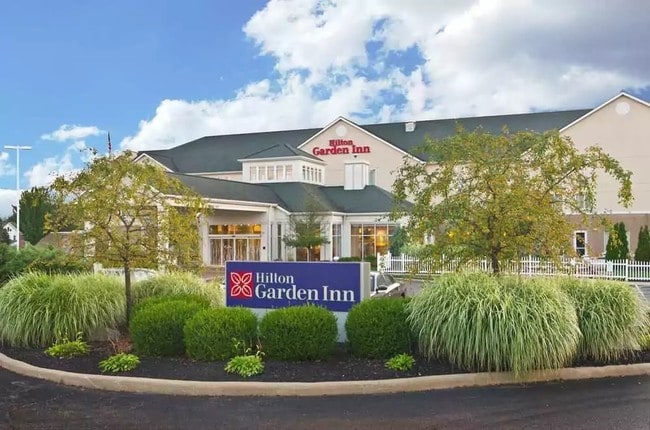
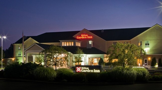
Property Record
959 Dover Rd, Wooster, OH 44691


Property Detail
959 Dover Rd
72-00008-000
SEC 15 SW LOT 75 CROCKER VILLAGE 2.774A MAP 254
Hotel
Wayne
C5
Ohio
B and X Area of moderate flood hazard, usually the area between the limits of the 100-year and 500-year floods.
75
2025
2.77 AC
2025
Ohio North Area
000500
Other Market Areas
61,107 SF
Wooster, OH
NEARBY LISTINGS FOR SALE OR LEASE
-
-
View all Wooster listings for sale on LoopNet.com
DEMOGRAPHICS near 959 Dover Rd
1 mile
3 mile
5 mile
2025 Total Population
1,636
17,775
36,000
2030 Population
1,652
17,822
36,097
Pop Growth 2025-2030
+ 0.98%
+ 0.26%
+ 0.27%
Average Age
37
38
40
2025 Total Households
586
6,569
14,196
HH Growth 2025-2030
+ 1.37%
+ 0.30%
+ 0.28%
Median Household Inc
$64,024
$62,773
$68,092
Avg Household Size
2.20
2.30
2.30
2025 Avg HH Vehicles
2.00
2.00
2.00
Median Home Value
$198,025
$196,450
$225,155
Median Year Built
1973
1959
1972
Nearby Places
Map Layers
Map Styles
 Street
 Aerial
Layers
 Traffic
 Biking
Places
Listings with unknown addresses are not visible on the map
- Restaurants
- Banks
- Shops
- Fitness
- Groceries
PUBLIC TRANSPORTATION
AIRPORT
Akron-Canton Regional
Drive
Walk
Distance
Akron-Canton Regional
55 min
43.2 mi
SALE & LEASE HISTORY
LISTING DATE
SALE/LEASE

May 04, 2021
For Sale
Nearby Properties
Address
Land Use
TOTAL SIZE
Lot Size
Zoning
Address
Land Use
TOTAL SIZE
Lot Size
Zoning
3,488 SF
43.72 AC
CF
Address
Land Use
TOTAL SIZE
Lot Size
Zoning
2,268 SF
106.60 AC
CF
Address
Land Use
TOTAL SIZE
Lot Size
Zoning
26,792 SF
64.92 AC
Address
Land Use
TOTAL SIZE
Lot Size
Zoning
81,133 SF
41.43 AC
CF
Address
Land Use
TOTAL SIZE
Lot Size
Zoning
7.28 AC
CF
Address
Land Use
TOTAL SIZE
Lot Size
Zoning
2,400 SF
99.04 AC
CF
Address
Land Use
TOTAL SIZE
Lot Size
Zoning
48,096 SF
1.67 AC
C4
Address
Land Use
TOTAL SIZE
Lot Size
Zoning
109.56 AC
M2
Address
Land Use
TOTAL SIZE
Lot Size
Zoning
25.14 AC
CF
Address
Land Use
TOTAL SIZE
Lot Size
Zoning
47,160 SF
3.22 AC
C4
Address
Land Use
TOTAL SIZE
Lot Size
Zoning
4,486 SF
5.57 AC
CF
Address
Land Use
TOTAL SIZE
Lot Size
Zoning
210,000 SF
20 AC
Address
Land Use
TOTAL SIZE
Lot Size
Zoning
58,600 SF
6.30 AC
CF
Address
Land Use
TOTAL SIZE
Lot Size
Zoning
10.68 AC
M3
Address
Land Use
TOTAL SIZE
Lot Size
Zoning
71,511 SF
9.53 AC
CF
Address
Land Use
TOTAL SIZE
Lot Size
Zoning
25,920 SF
42 AC
CF
Address
Land Use
TOTAL SIZE
Lot Size
Zoning
89,980 SF
17.58 AC
M2
Address
Land Use
TOTAL SIZE
Lot Size
Zoning
2,380 SF
10.01 AC
CF
Address
Land Use
TOTAL SIZE
Lot Size
Zoning
1,890 SF
6.96 AC
CF
Address
Land Use
TOTAL SIZE
Lot Size
Zoning
54,501 SF
3.96 AC
C5
Address
Land Use
TOTAL SIZE
Lot Size
Zoning
82,000 SF
26.83 AC
Address
Land Use
TOTAL SIZE
Lot Size
Zoning
17.43 AC
M2
Address
Land Use
TOTAL SIZE
Lot Size
Zoning
40.89 AC
Address
Land Use
TOTAL SIZE
Lot Size
Zoning
69,768 SF
0.74 AC
C4
Address
Land Use
TOTAL SIZE
Lot Size
Zoning
13.10 AC
M2
Address
Land Use
TOTAL SIZE
Lot Size
Zoning
3,057 SF
163.13 AC
CF
Address
Land Use
TOTAL SIZE
Lot Size
Zoning
52,194 SF
2.93 AC
C2
Address
Land Use
TOTAL SIZE
Lot Size
Zoning
8,517 SF
5.47 AC
Address
Land Use
TOTAL SIZE
Lot Size
Zoning
210,000 SF
19.54 AC
The World's #1 Commercial Real Estate Marketplace
Connect with us
© 2026 CoStar Group
The information above has been obtained from sources believed reliable. While we do not doubt its accuracy we have not verified it and make no guarantee, warranty or representation about it. It is your responsibility to independently confirm its accuracy and completeness. Any projections, opinions, assumptions, or estimates used are for example only and do not represent the current or future performance of the property. The value of this transaction to you depends on tax and other factors which should be evaluated by your tax, financial, and legal advisors. You and your advisors should conduct a careful, independent investigation of the property to determine to your satisfaction the suitability of the property for your needs.