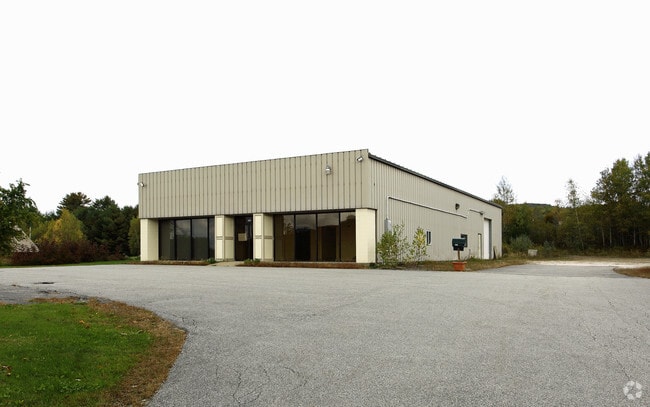
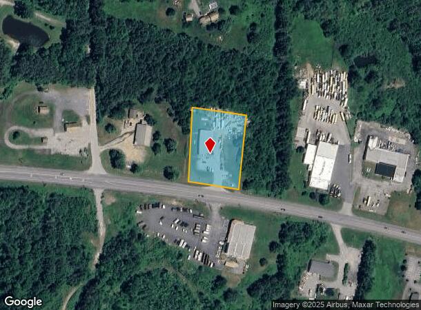
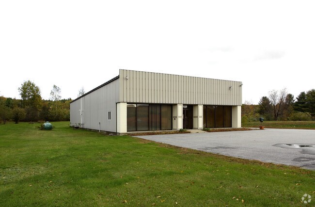
Property Record
959 John Stark Hwy, Newport, NH 03773
NEARBY LISTINGS FOR SALE OR LEASE
Property Detail
959 John Stark Hwy
Commercialbuilding
Sullivan
X
New Hampshire
33019C0285E
1.50 AC
2024
Concord/New Hampshire North Area
2024
Other Market Areas
975402
Claremont-Lebanon, NH-VT
5,242 SF
NWPT-000236-022000
DEMOGRAPHICS near 959 John Stark Hwy
1 Mile
3 Mile
5 Mile
2024 Total Population
151
1,648
16,954
2029 Population
159
1,732
17,898
Pop Growth 2024-2029
+ 5.30%
+ 5.10%
+ 5.57%
Average Age
46
44
43
2024 Total Households
59
646
7,139
HH Growth 2024-2029
+ 5.08%
+ 4.80%
+ 5.28%
Median Household Inc
$73,499
$67,077
$50,270
Avg Household Size
2.40
2.40
2.20
2024 Avg HH Vehicles
2.00
2.00
2.00
Median Home Value
$230,000
$182,383
$171,054
Median Year Built
1977
1971
1964
Nearby Places
Map Layers
Map Styles
 Street
 Aerial
- Restaurants
- Banks
- Shops
- Fitness
- Groceries
PUBLIC TRANSPORTATION
COMMUTER RAIL
Claremont Amtrak (Vermonter - Amtrak)
DRIVE
WALK
Distance
Claremont Amtrak (Vermonter - Amtrak)
11 min
7.4 mi
Freight Ports
Albany, NY Port
DRIVE
WALK
Distance
Albany, NY Port
178 min
116.2 mi
Nearby Properties
Address
Land Use
TOTAL SIZE
Lot Size
Zoning
Address
Land Use
TOTAL SIZE
Lot Size
Zoning
104,633 SF
10.48 AC
B2
Address
Land Use
TOTAL SIZE
Lot Size
Zoning
150,192 SF
6.78 AC
B2
Address
Land Use
TOTAL SIZE
Lot Size
Zoning
31,532 SF
31.79 AC
IND I
Address
Land Use
TOTAL SIZE
Lot Size
Zoning
3,900 SF
4.85 AC
B2
Address
Land Use
TOTAL SIZE
Lot Size
Zoning
150,000 SF
6 AC
B2
Address
Land Use
TOTAL SIZE
Lot Size
Zoning
3.34 AC
AR
Address
Land Use
TOTAL SIZE
Lot Size
Zoning
21,528 SF
6.83 AC
RC5 R
Address
Land Use
TOTAL SIZE
Lot Size
Zoning
40,121 SF
8.40 AC
K40 K
Address
Land Use
TOTAL SIZE
Lot Size
Zoning
3,125 SF
9.72 AC
RC5 R
Address
Land Use
TOTAL SIZE
Lot Size
Zoning
7,027 SF
5.38 AC
RC5 R
Address
Land Use
TOTAL SIZE
Lot Size
Zoning
10 AC
RR
Address
Land Use
TOTAL SIZE
Lot Size
Zoning
3,125 SF
5.01 AC
RC5 R
Address
Land Use
TOTAL SIZE
Lot Size
Zoning
3,125 SF
5.01 AC
RC5 R
Address
Land Use
TOTAL SIZE
Lot Size
Zoning
14,177 SF
25.23 AC
K40 K
Address
Land Use
TOTAL SIZE
Lot Size
Zoning
5,443 SF
1.33 AC
B2
Address
Land Use
TOTAL SIZE
Lot Size
Zoning
5,533 SF
7.70 AC
RC5 R
Address
Land Use
TOTAL SIZE
Lot Size
Zoning
1,933 SF
6.80 AC
RC5 R
Address
Land Use
TOTAL SIZE
Lot Size
Zoning
19,555 SF
5 AC
RC5 R
Address
Land Use
TOTAL SIZE
Lot Size
Zoning
13,290 SF
24 AC
RC5 R
Address
Land Use
TOTAL SIZE
Lot Size
Zoning
6,377 SF
5 AC
K40 K
Address
Land Use
TOTAL SIZE
Lot Size
Zoning
2,740 SF
23 AC
RC5 R
Address
Land Use
TOTAL SIZE
Lot Size
Zoning
10,479 SF
5 AC
RC5 R
Address
Land Use
TOTAL SIZE
Lot Size
Zoning
4,953 SF
1.20 AC
RC5 R
Address
Land Use
TOTAL SIZE
Lot Size
Zoning
5,075 SF
7.60 AC
R40 R
Address
Land Use
TOTAL SIZE
Lot Size
Zoning
1,818 SF
37 AC
RR
Address
Land Use
TOTAL SIZE
Lot Size
Zoning
2,503 SF
1.13 AC
K40 K
Address
Land Use
TOTAL SIZE
Lot Size
Zoning
3,828 SF
1.29 AC
B2
Address
Land Use
TOTAL SIZE
Lot Size
Zoning
8,712 SF
1.30 AC
K40 K
Address
Land Use
TOTAL SIZE
Lot Size
Zoning
6,515 SF
4.90 AC
RC5 R
Address
Land Use
TOTAL SIZE
Lot Size
Zoning
2,920 SF
7.10 AC
R40 R
The World's #1 Commercial Real Estate Marketplace
Connect with us
© 2026 CoStar Group
The information above has been obtained from sources believed reliable. While we do not doubt its accuracy we have not verified it and make no guarantee, warranty or representation about it. It is your responsibility to independently confirm its accuracy and completeness. Any projections, opinions, assumptions, or estimates used are for example only and do not represent the current or future performance of the property. The value of this transaction to you depends on tax and other factors which should be evaluated by your tax, financial, and legal advisors. You and your advisors should conduct a careful, independent investigation of the property to determine to your satisfaction the suitability of the property for your needs.