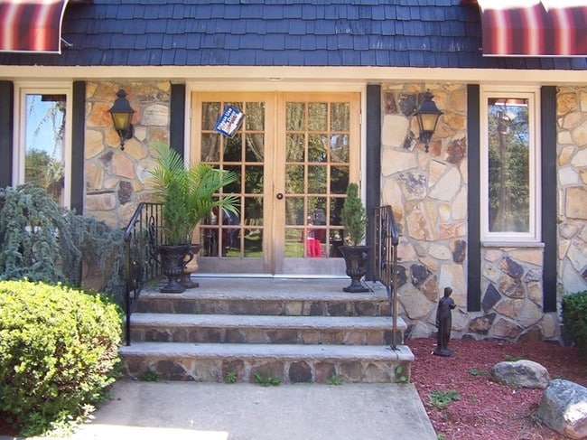
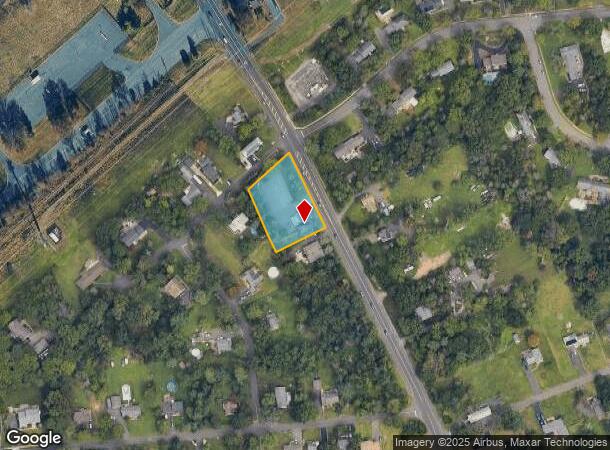
Property Record
959 Us Highway 202/206, Bridgewater, NJ 08807
NEARBY LISTINGS FOR SALE OR LEASE
Property Detail
959 Us Highway 202/206
06-00480-0000-00003
Somerset
Vacantlandnec
New Jersey
X
3
34035C0132E
0.81 AC
2024
Route 78 East
2025
Northern New Jersey
050802
Newark, NJ-PA
DEMOGRAPHICS near 959 Us Highway 202/206
1 Mile
3 Mile
5 Mile
2024 Total Population
4,414
37,303
96,660
2029 Population
4,415
37,447
97,091
Pop Growth 2024-2029
+ 0.02%
+ 0.39%
+ 0.45%
Average Age
44
43
42
2024 Total Households
1,512
14,035
36,621
HH Growth 2024-2029
(0.07%)
+ 0.32%
+ 0.45%
Median Household Inc
$171,887
$156,029
$132,683
Avg Household Size
2.80
2.60
2.60
2024 Avg HH Vehicles
2.00
2.00
2.00
Median Home Value
$657,211
$597,632
$506,170
Median Year Built
1966
1985
1982
Nearby Places
Map Layers
Map Styles
 Street
 Aerial
- Restaurants
- Banks
- Shops
- Fitness
- Groceries
PUBLIC TRANSPORTATION
COMMUTER RAIL
Raritan (Raritan Valley Line - NJ Transit Commuter Rail (NJ Transit))
DRIVE
WALK
Distance
Raritan (Raritan Valley Line - NJ Transit Commuter Rail (NJ Transit))
7 min
4.1 mi
North Branch (Raritan Valley Line - NJ Transit Commuter Rail (NJ Transit))
DRIVE
WALK
Distance
North Branch (Raritan Valley Line - NJ Transit Commuter Rail (NJ Transit))
11 min
6.6 mi
AIRPORT
Trenton Mercer
DRIVE
WALK
Distance
Trenton Mercer
53 min
33.7 mi
Newark Liberty International
DRIVE
WALK
Distance
Newark Liberty International
43 min
34.2 mi
Freight Ports
New York Container Terminal
DRIVE
WALK
Distance
New York Container Terminal
46 min
35.7 mi
Nearby Properties
Address
Land Use
TOTAL SIZE
Lot Size
Zoning
Address
Land Use
TOTAL SIZE
Lot Size
Zoning
26.42 AC
C2
Address
Land Use
TOTAL SIZE
Lot Size
Zoning
Address
Land Use
TOTAL SIZE
Lot Size
Zoning
2.82 AC
SED
Address
Land Use
TOTAL SIZE
Lot Size
Zoning
81.89 AC
M1
Address
Land Use
TOTAL SIZE
Lot Size
Zoning
85,000 SF
25.62 AC
E3
Address
Land Use
TOTAL SIZE
Lot Size
Zoning
19.34 AC
M1
Address
Land Use
TOTAL SIZE
Lot Size
Zoning
19.36 AC
M1
Address
Land Use
TOTAL SIZE
Lot Size
Zoning
8.26 AC
R40
Address
Land Use
TOTAL SIZE
Lot Size
Zoning
10.47 AC
C2
Address
Land Use
TOTAL SIZE
Lot Size
Zoning
9.91 AC
C2
Address
Land Use
TOTAL SIZE
Lot Size
Zoning
8.60 AC
C2
Address
Land Use
TOTAL SIZE
Lot Size
Zoning
34.26 AC
Address
Land Use
TOTAL SIZE
Lot Size
Zoning
12.74 AC
PUD
Address
Land Use
TOTAL SIZE
Lot Size
Zoning
13.94 AC
PUD
Address
Land Use
TOTAL SIZE
Lot Size
Zoning
12.53 AC
M1
Address
Land Use
TOTAL SIZE
Lot Size
Zoning
18.99 AC
M1
Address
Land Use
TOTAL SIZE
Lot Size
Zoning
28.44 AC
C2
Address
Land Use
TOTAL SIZE
Lot Size
Zoning
53.99 AC
R40
Address
Land Use
TOTAL SIZE
Lot Size
Zoning
19.96 AC
GCM
Address
Land Use
TOTAL SIZE
Lot Size
Zoning
146.60 AC
SED
Address
Land Use
TOTAL SIZE
Lot Size
Zoning
1.21 AC
SED
Address
Land Use
TOTAL SIZE
Lot Size
Zoning
2,848 SF
22.47 AC
ORVM
Address
Land Use
TOTAL SIZE
Lot Size
Zoning
10.06 AC
R40
Address
Land Use
TOTAL SIZE
Lot Size
Zoning
10.43 AC
Address
Land Use
TOTAL SIZE
Lot Size
Zoning
17.63 AC
OR
Address
Land Use
TOTAL SIZE
Lot Size
Zoning
Address
Land Use
TOTAL SIZE
Lot Size
Zoning
12.50 AC
C2
Address
Land Use
TOTAL SIZE
Lot Size
Zoning
Address
Land Use
TOTAL SIZE
Lot Size
Zoning
20.80 AC
M1
Address
Land Use
TOTAL SIZE
Lot Size
Zoning
30.52 AC
R50
The World's #1 Commercial Real Estate Marketplace
Connect with us
© 2025 CoStar Group
The information above has been obtained from sources believed reliable. While we do not doubt its accuracy we have not verified it and make no guarantee, warranty or representation about it. It is your responsibility to independently confirm its accuracy and completeness. Any projections, opinions, assumptions, or estimates used are for example only and do not represent the current or future performance of the property. The value of this transaction to you depends on tax and other factors which should be evaluated by your tax, financial, and legal advisors. You and your advisors should conduct a careful, independent investigation of the property to determine to your satisfaction the suitability of the property for your needs.