Property Record
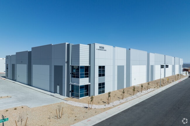
9590 S Rainbow Blvd, Las Vegas, NV 89139


Current Lease Availabilities
NEARBY LISTINGS FOR SALE OR LEASE
Property Detail
9590 S Rainbow Blvd
Las Vegas
Ebs At Rainbow & Richmar
Las Vegas-Henderson-Paradise, NV
EBS AT RAINBOW & RICHMAR PLAT BOOK 171 PAGE 75 PT LOT 1
176-23-411-004
Clark
Shipyard
Nevada
0
1
2025
4.19 AC
005831
SW Las Vegas
DEMOGRAPHICS near 9590 S Rainbow Blvd
1 Mile
3 Mile
5 Mile
2024 Total Population
5,700
140,794
257,800
2029 Population
6,236
153,110
280,804
Pop Growth 2024-2029
+ 9.40%
+ 8.75%
+ 8.92%
Average Age
37
37
37
2024 Total Households
1,890
47,771
93,172
HH Growth 2024-2029
+ 9.37%
+ 8.70%
+ 8.82%
Median Household Inc
$103,652
$92,517
$87,152
Avg Household Size
2.90
2.90
2.70
2024 Avg HH Vehicles
2.00
2.00
2.00
Median Home Value
$458,705
$427,936
$426,761
Median Year Built
2010
2008
2007
Nearby Places
Map Layers
Map Styles
 Street
 Aerial
- Restaurants
- Banks
- Shops
- Fitness
- Groceries
PUBLIC TRANSPORTATION
AIRPORT
Harry Reid International
DRIVE
WALK
Distance
Harry Reid International
15 min
9.4 mi
Boulder City Municipal
DRIVE
WALK
Distance
Boulder City Municipal
38 min
27.0 mi
Freight Ports
Port of Long Beach
DRIVE
WALK
Distance
Port of Long Beach
310 min
275.8 mi
Nearby Properties
Address
Land Use
TOTAL SIZE
Lot Size
Zoning
Address
Land Use
TOTAL SIZE
Lot Size
Zoning
60 AC
PF
Address
Land Use
TOTAL SIZE
Lot Size
Zoning
17,206 SF
225 AC
Address
Land Use
TOTAL SIZE
Lot Size
Zoning
Address
Land Use
TOTAL SIZE
Lot Size
Zoning
35.55 AC
PF
Address
Land Use
TOTAL SIZE
Lot Size
Zoning
239,500 SF
13.18 AC
Address
Land Use
TOTAL SIZE
Lot Size
Zoning
3,398 SF
13.56 AC
Address
Land Use
TOTAL SIZE
Lot Size
Zoning
9.34 AC
Address
Land Use
TOTAL SIZE
Lot Size
Zoning
4,830 SF
15.84 AC
Address
Land Use
TOTAL SIZE
Lot Size
Zoning
4,199 SF
12.11 AC
RE
Address
Land Use
TOTAL SIZE
Lot Size
Zoning
6,782 SF
17.45 AC
R3
Address
Land Use
TOTAL SIZE
Lot Size
Zoning
370,870 SF
28.56 AC
MD
Address
Land Use
TOTAL SIZE
Lot Size
Zoning
5,921 SF
17.62 AC
RE
Address
Land Use
TOTAL SIZE
Lot Size
Zoning
14.65 AC
RE
Address
Land Use
TOTAL SIZE
Lot Size
Zoning
18.03 AC
PF
Address
Land Use
TOTAL SIZE
Lot Size
Zoning
5,697 SF
10.66 AC
R3
Address
Land Use
TOTAL SIZE
Lot Size
Zoning
53,331 SF
77.50 AC
Address
Land Use
TOTAL SIZE
Lot Size
Zoning
192,814 SF
20.27 AC
Address
Land Use
TOTAL SIZE
Lot Size
Zoning
6,095 SF
13.82 AC
Address
Land Use
TOTAL SIZE
Lot Size
Zoning
494,886 SF
26.61 AC
M1
Address
Land Use
TOTAL SIZE
Lot Size
Zoning
7,121 SF
14.27 AC
R3
Address
Land Use
TOTAL SIZE
Lot Size
Zoning
5,931 SF
3.80 AC
R3
Address
Land Use
TOTAL SIZE
Lot Size
Zoning
186,421 SF
19.06 AC
Address
Land Use
TOTAL SIZE
Lot Size
Zoning
9,787 SF
65.73 AC
RE
Address
Land Use
TOTAL SIZE
Lot Size
Zoning
17.85 AC
PF
Address
Land Use
TOTAL SIZE
Lot Size
Zoning
86,780 SF
14.58 AC
PF
Address
Land Use
TOTAL SIZE
Lot Size
Zoning
191,189 SF
4.53 AC
C2
Address
Land Use
TOTAL SIZE
Lot Size
Zoning
15 AC
RE
Address
Land Use
TOTAL SIZE
Lot Size
Zoning
136,654 SF
15 AC
PF
Address
Land Use
TOTAL SIZE
Lot Size
Zoning
124,257 SF
16.11 AC
Address
Land Use
TOTAL SIZE
Lot Size
Zoning
72,754 SF
4.49 AC
CP
The World's #1 Commercial Real Estate Marketplace
Connect with us
© 2026 CoStar Group
The information above has been obtained from sources believed reliable. While we do not doubt its accuracy we have not verified it and make no guarantee, warranty or representation about it. It is your responsibility to independently confirm its accuracy and completeness. Any projections, opinions, assumptions, or estimates used are for example only and do not represent the current or future performance of the property. The value of this transaction to you depends on tax and other factors which should be evaluated by your tax, financial, and legal advisors. You and your advisors should conduct a careful, independent investigation of the property to determine to your satisfaction the suitability of the property for your needs.