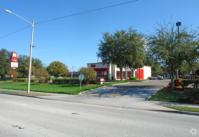
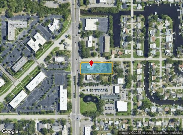
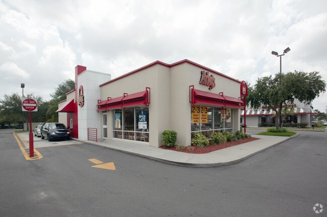
Property Record
9597 4Th St N, Saint Petersburg, FL 33702

NEARBY LISTINGS FOR SALE OR LEASE
Property Detail
9597 4Th St N
Tampa-St. Petersburg-Clearwater, FL
Boston Chickens
19-30-17-10348-001-0010
BOSTON CHICKENS 4TH STREET SUB BLK 1, LOT 1
Restaurantdrivein
Pinellas
AE
Florida
12103C0207H
1
2024
1.08 AC
2025
Gateway
024411
Tampa/St Petersburg
3,079 SF
DEMOGRAPHICS near 9597 4Th St N
1 Mile
3 Mile
5 Mile
2024 Total Population
13,154
62,629
152,602
2029 Population
13,032
63,109
153,029
Pop Growth 2024-2029
(0.93%)
+ 0.77%
+ 0.28%
Average Age
40
43
43
2024 Total Households
6,618
31,660
71,012
HH Growth 2024-2029
(1.34%)
+ 0.63%
+ 0.15%
Median Household Inc
$60,099
$63,079
$63,061
Avg Household Size
1.90
1.90
2.10
2024 Avg HH Vehicles
1.00
1.00
2.00
Median Home Value
$267,618
$234,859
$261,848
Median Year Built
1978
1978
1973
Nearby Places
Map Layers
Map Styles
 Street
 Aerial
- Restaurants
- Banks
- Shops
- Fitness
- Groceries
PUBLIC TRANSPORTATION
AIRPORT
St Pete-Clearwater International
DRIVE
WALK
Distance
St Pete-Clearwater International
10 min
5.5 mi
Tampa International
DRIVE
WALK
Distance
Tampa International
21 min
13.9 mi
Sarasota/Bradenton International
DRIVE
WALK
Distance
Sarasota/Bradenton International
58 min
40.3 mi
Freight Ports
Port of Tampa Bay
DRIVE
WALK
Distance
Port of Tampa Bay
28 min
17.8 mi
Nearby Properties
Address
Land Use
TOTAL SIZE
Lot Size
Zoning
Address
Land Use
TOTAL SIZE
Lot Size
Zoning
1,160,631 SF
28.08 AC
Address
Land Use
TOTAL SIZE
Lot Size
Zoning
1,232,878 SF
12.64 AC
Address
Land Use
TOTAL SIZE
Lot Size
Zoning
547,276 SF
27.35 AC
Address
Land Use
TOTAL SIZE
Lot Size
Zoning
551,317 SF
52.55 AC
Address
Land Use
TOTAL SIZE
Lot Size
Zoning
749,164 SF
7.11 AC
Address
Land Use
TOTAL SIZE
Lot Size
Zoning
428,587 SF
14.35 AC
Address
Land Use
TOTAL SIZE
Lot Size
Zoning
484,229 SF
28 AC
Address
Land Use
TOTAL SIZE
Lot Size
Zoning
466,420 SF
2.60 AC
Address
Land Use
TOTAL SIZE
Lot Size
Zoning
447,664 SF
34.44 AC
Address
Land Use
TOTAL SIZE
Lot Size
Zoning
171,420 SF
300.24 AC
M1
Address
Land Use
TOTAL SIZE
Lot Size
Zoning
350,604 SF
13.21 AC
Address
Land Use
TOTAL SIZE
Lot Size
Zoning
429,226 SF
0.85 AC
Address
Land Use
TOTAL SIZE
Lot Size
Zoning
416,482 SF
14.93 AC
Address
Land Use
TOTAL SIZE
Lot Size
Zoning
346,420 SF
17.95 AC
Address
Land Use
TOTAL SIZE
Lot Size
Zoning
372,436 SF
22.30 AC
Address
Land Use
TOTAL SIZE
Lot Size
Zoning
486,722 SF
16.63 AC
Address
Land Use
TOTAL SIZE
Lot Size
Zoning
404,063 SF
12.98 AC
Address
Land Use
TOTAL SIZE
Lot Size
Zoning
401,627 SF
0.66 AC
Address
Land Use
TOTAL SIZE
Lot Size
Zoning
386,416 SF
18.04 AC
Address
Land Use
TOTAL SIZE
Lot Size
Zoning
308,107 SF
32.37 AC
Address
Land Use
TOTAL SIZE
Lot Size
Zoning
240,736 SF
58.40 AC
Address
Land Use
TOTAL SIZE
Lot Size
Zoning
337,137 SF
26.72 AC
M1
Address
Land Use
TOTAL SIZE
Lot Size
Zoning
359,527 SF
19.65 AC
Address
Land Use
TOTAL SIZE
Lot Size
Zoning
342,645 SF
12.59 AC
Address
Land Use
TOTAL SIZE
Lot Size
Zoning
324,579 SF
16.97 AC
Address
Land Use
TOTAL SIZE
Lot Size
Zoning
309,526 SF
36.85 AC
C2
Address
Land Use
TOTAL SIZE
Lot Size
Zoning
265,688 SF
27.52 AC
Address
Land Use
TOTAL SIZE
Lot Size
Zoning
243,101 SF
24.86 AC
Address
Land Use
TOTAL SIZE
Lot Size
Zoning
444,770 SF
14.95 AC
Address
Land Use
TOTAL SIZE
Lot Size
Zoning
464,493 SF
17.41 AC
The World's #1 Commercial Real Estate Marketplace
Connect with us
© 2025 CoStar Group
The information above has been obtained from sources believed reliable. While we do not doubt its accuracy we have not verified it and make no guarantee, warranty or representation about it. It is your responsibility to independently confirm its accuracy and completeness. Any projections, opinions, assumptions, or estimates used are for example only and do not represent the current or future performance of the property. The value of this transaction to you depends on tax and other factors which should be evaluated by your tax, financial, and legal advisors. You and your advisors should conduct a careful, independent investigation of the property to determine to your satisfaction the suitability of the property for your needs.