Property Record
960 Avis Dr, El Cerrito, CA 94530

NEARBY LISTINGS FOR SALE OR LEASE
-
-
View all El Cerrito listings for sale on LoopNet.com
Property Detail
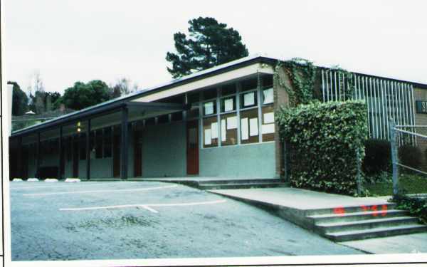
960 Avis Dr
Oakland-Fremont-Berkeley, CA
Berkeley Country Club Terrace
503-280-002-0
SOME INFO KEYED FROM LEGAL DESCRIPTION, BUT COMPLETE LEGAL NOT CAPTURED
Publicschool
Contra Costa
X
California
06013C0241G
66
2025
4 AC
2025
Richmond/San Pablo
390100
East Bay/Oakland
29,245 SF
DEMOGRAPHICS near 960 Avis Dr
1 mile
3 mile
5 mile
2024 Total Population
21,073
127,104
337,167
2029 Population
20,887
124,985
331,256
Pop Growth 2024-2029
(0.88%)
(1.67%)
(1.75%)
Average Age
43
42
39
2024 Total Households
8,507
48,534
121,038
HH Growth 2024-2029
(0.89%)
(1.78%)
(1.90%)
Median Household Inc
$116,434
$111,066
$92,210
Avg Household Size
2.40
2.50
2.60
2024 Avg HH Vehicles
2.00
2.00
2.00
Median Home Value
$1,012,767
$1,004,622
$901,226
Median Year Built
1954
1953
1956
Nearby Places
Map Layers
Map Styles
 Street
 Aerial
Transit
 Traffic
 Biking
Places
Listings with unknown addresses are not visible on the map
- Restaurants
- Banks
- Shops
- Fitness
- Groceries
PUBLIC TRANSPORTATION
TRANSIT/SUBWAY
El Cerrito Plaza Station (Fremont - Richmond - Bay Area Rapid Transit (BART), Richmond - Millbrae - Bay Area Rapid Transit (BART))
Drive
Walk
Distance
El Cerrito Plaza Station (Fremont - Richmond - Bay Area Rapid Transit (BART), Richmond - Millbrae - Bay Area Rapid Transit (BART))
3 min
20 min
1.0 mi
COMMUTER RAIL
Richmond (Capitol Corridor - Capitol Corridor Joint Powers Authority)
Drive
Walk
Distance
Richmond (Capitol Corridor - Capitol Corridor Joint Powers Authority)
9 min
4.4 mi
Berkeley (Capitol Corridor - Amtrak)
Drive
Walk
Distance
Berkeley (Capitol Corridor - Amtrak)
9 min
5.0 mi
AIRPORT
Metro Oakland International
Drive
Walk
Distance
Metro Oakland International
29 min
19.4 mi
San Francisco International
Drive
Walk
Distance
San Francisco International
41 min
27.1 mi
Freight Ports
Port of Richmond
Drive
Walk
Distance
Port of Richmond
16 min
7.6 mi
Nearby Properties
Address
Land Use
TOTAL SIZE
Lot Size
Zoning
Address
Land Use
TOTAL SIZE
Lot Size
Zoning
820,000 SF
6.36 AC
Address
Land Use
TOTAL SIZE
Lot Size
Zoning
254,000 SF
1.71 AC
Address
Land Use
TOTAL SIZE
Lot Size
Zoning
12.31 AC
Address
Land Use
TOTAL SIZE
Lot Size
Zoning
202,811 SF
10.98 AC
Address
Land Use
TOTAL SIZE
Lot Size
Zoning
191,800 SF
1.09 AC
Address
Land Use
TOTAL SIZE
Lot Size
Zoning
124,257 SF
2.72 AC
Address
Land Use
TOTAL SIZE
Lot Size
Zoning
69,949 SF
0.65 AC
C2 CD
Address
Land Use
TOTAL SIZE
Lot Size
Zoning
47,575 SF
1.79 AC
Address
Land Use
TOTAL SIZE
Lot Size
Zoning
81,352 SF
5.06 AC
C2
Address
Land Use
TOTAL SIZE
Lot Size
Zoning
71,774 SF
12.66 AC
Address
Land Use
TOTAL SIZE
Lot Size
Zoning
162,660 SF
9.09 AC
Address
Land Use
TOTAL SIZE
Lot Size
Zoning
404,098 SF
24.03 AC
MSL1RD
Address
Land Use
TOTAL SIZE
Lot Size
Zoning
159,302 SF
3.01 AC
Address
Land Use
TOTAL SIZE
Lot Size
Zoning
54,728 SF
0.96 AC
Address
Land Use
TOTAL SIZE
Lot Size
Zoning
147,500 SF
9.84 AC
Address
Land Use
TOTAL SIZE
Lot Size
Zoning
136,648 SF
13.27 AC
Address
Land Use
TOTAL SIZE
Lot Size
Zoning
137,293 SF
10.52 AC
Address
Land Use
TOTAL SIZE
Lot Size
Zoning
107,100 SF
27.35 AC
Address
Land Use
TOTAL SIZE
Lot Size
Zoning
113,960 SF
6 AC
Address
Land Use
TOTAL SIZE
Lot Size
Zoning
67,968 SF
5.62 AC
Address
Land Use
TOTAL SIZE
Lot Size
Zoning
70,275 SF
1.30 AC
Address
Land Use
TOTAL SIZE
Lot Size
Zoning
10.90 AC
Address
Land Use
TOTAL SIZE
Lot Size
Zoning
121,064 SF
3.46 AC
Address
Land Use
TOTAL SIZE
Lot Size
Zoning
31,475 SF
2.18 AC
Address
Land Use
TOTAL SIZE
Lot Size
Zoning
6,880 SF
3.45 AC
Address
Land Use
TOTAL SIZE
Lot Size
Zoning
167,992 SF
7.54 AC
Address
Land Use
TOTAL SIZE
Lot Size
Zoning
40,919 SF
1.95 AC
Address
Land Use
TOTAL SIZE
Lot Size
Zoning
36,757 SF
1.35 AC
Address
Land Use
TOTAL SIZE
Lot Size
Zoning
67,290 SF
0.49 AC
Address
Land Use
TOTAL SIZE
Lot Size
Zoning
156,960 SF
6.92 AC
The World's #1 Commercial Real Estate Marketplace
Connect with us
© 2026 CoStar Group
The information above has been obtained from sources believed reliable. While we do not doubt its accuracy we have not verified it and make no guarantee, warranty or representation about it. It is your responsibility to independently confirm its accuracy and completeness. Any projections, opinions, assumptions, or estimates used are for example only and do not represent the current or future performance of the property. The value of this transaction to you depends on tax and other factors which should be evaluated by your tax, financial, and legal advisors. You and your advisors should conduct a careful, independent investigation of the property to determine to your satisfaction the suitability of the property for your needs.