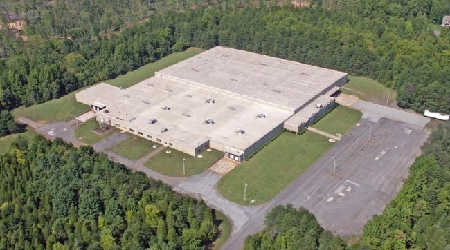
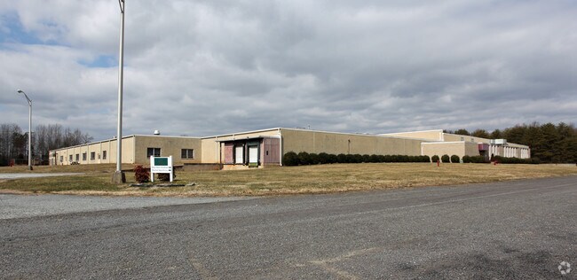
Property Record
960 Milling Rd, Mocksville, NC 27028

Property Detail
960 Milling Rd
I5-000-00-023
31.54 AC MILLING RD
Manufacturinglight
DAVIE
CB
North Carolina
B and X Area of moderate flood hazard, usually the area between the limits of the 100-year and 500-year floods.
30.67 AC
2025
Davie County
2025
Greensboro/Winston-Salem
080600
Winston-Salem, NC
168,820 SF
NEARBY LISTINGS FOR SALE OR LEASE
DEMOGRAPHICS near 960 Milling Rd
1 mile
3 mile
5 mile
2025 Total Population
2,286
9,789
17,057
2030 Population
2,397
10,279
17,898
Pop Growth 2025-2030
+ 4.86%
+ 5.01%
+ 4.93%
Average Age
41
42
42
2025 Total Households
862
3,849
6,736
HH Growth 2025-2030
+ 4.76%
+ 4.91%
+ 4.81%
Median Household Inc
$65,553
$68,525
$71,794
Avg Household Size
2.60
2.50
2.50
2025 Avg HH Vehicles
2.00
2.00
2.00
Median Home Value
$237,086
$262,184
$263,014
Median Year Built
1989
1989
1987
Nearby Places
Map Layers
Map Styles
 Street
 Aerial
Transit
 Traffic
 Biking
Places
Listings with unknown addresses are not visible on the map
- Restaurants
- Banks
- Shops
- Fitness
- Groceries
Nearby Properties
Address
Land Use
TOTAL SIZE
Lot Size
Zoning
Address
Land Use
TOTAL SIZE
Lot Size
Zoning
50,164 SF
118.49 AC
TC
Address
Land Use
TOTAL SIZE
Lot Size
Zoning
151,423 SF
93.36 AC
TC
Address
Land Use
TOTAL SIZE
Lot Size
Zoning
73,703 SF
32.48 AC
R20
Address
Land Use
TOTAL SIZE
Lot Size
Zoning
136,000 SF
18.79 AC
TC
Address
Land Use
TOTAL SIZE
Lot Size
Zoning
235,064 SF
27.27 AC
TC
Address
Land Use
TOTAL SIZE
Lot Size
Zoning
37,437 SF
3.24 AC
TC
Address
Land Use
TOTAL SIZE
Lot Size
Zoning
109,337 SF
6.01 AC
TC
Address
Land Use
TOTAL SIZE
Lot Size
Zoning
6,560 SF
49.38 AC
Address
Land Use
TOTAL SIZE
Lot Size
Zoning
26,000 SF
28.21 AC
CI
Address
Land Use
TOTAL SIZE
Lot Size
Zoning
99,281 SF
25.44 AC
TC
Address
Land Use
TOTAL SIZE
Lot Size
Zoning
76,806 SF
60.98 AC
HC
Address
Land Use
TOTAL SIZE
Lot Size
Zoning
233,076 SF
10.25 AC
TC
Address
Land Use
TOTAL SIZE
Lot Size
Zoning
29,427 SF
4.60 AC
NR
Address
Land Use
TOTAL SIZE
Lot Size
Zoning
33,020 SF
5.05 AC
Address
Land Use
TOTAL SIZE
Lot Size
Zoning
5,760 SF
15.25 AC
NR
Address
Land Use
TOTAL SIZE
Lot Size
Zoning
62,800 SF
21.61 AC
CI
Address
Land Use
TOTAL SIZE
Lot Size
Zoning
394,265 SF
46.94 AC
TC
Address
Land Use
TOTAL SIZE
Lot Size
Zoning
9,050 SF
16.33 AC
NR
Address
Land Use
TOTAL SIZE
Lot Size
Zoning
171,794 SF
16.08 AC
Address
Land Use
TOTAL SIZE
Lot Size
Zoning
25,966 SF
0.55 AC
TC
Address
Land Use
TOTAL SIZE
Lot Size
Zoning
49,836 SF
8.97 AC
HC
Address
Land Use
TOTAL SIZE
Lot Size
Zoning
106,920 SF
6.85 AC
TC
Address
Land Use
TOTAL SIZE
Lot Size
Zoning
105,712 SF
12.03 AC
R20
Address
Land Use
TOTAL SIZE
Lot Size
Zoning
35,145 SF
11.54 AC
CI
Address
Land Use
TOTAL SIZE
Lot Size
Zoning
9,828 SF
13.99 AC
NC
Address
Land Use
TOTAL SIZE
Lot Size
Zoning
6,900 SF
3.69 AC
HC
Address
Land Use
TOTAL SIZE
Lot Size
Zoning
14,820 SF
3.44 AC
HC
Address
Land Use
TOTAL SIZE
Lot Size
Zoning
6,048 SF
8.50 AC
NR
Address
Land Use
TOTAL SIZE
Lot Size
Zoning
12,852 SF
1.94 AC
NC
The World's #1 Commercial Real Estate Marketplace
Connect with us
© 2026 CoStar Group
The information above has been obtained from sources believed reliable. While we do not doubt its accuracy we have not verified it and make no guarantee, warranty or representation about it. It is your responsibility to independently confirm its accuracy and completeness. Any projections, opinions, assumptions, or estimates used are for example only and do not represent the current or future performance of the property. The value of this transaction to you depends on tax and other factors which should be evaluated by your tax, financial, and legal advisors. You and your advisors should conduct a careful, independent investigation of the property to determine to your satisfaction the suitability of the property for your needs.