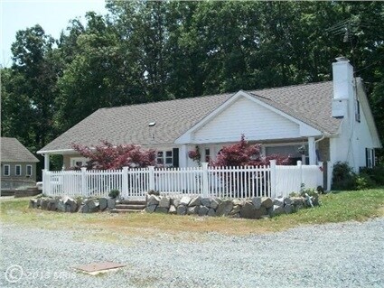
Property Record
960 W Pulaski Hwy, Elkton, MD 21921

NEARBY LISTINGS FOR SALE OR LEASE
-
-
View all Elkton listings for sale on LoopNet.com
Property Detail
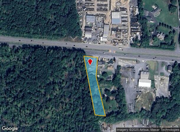
960 W Pulaski Hwy
Philadelphia-Camden-Wilmington, PA-NJ-DE-MD
Glen Farms
03-022757
1.381 ACRE 960 WEST PULASKI HIGHWAY W OF ELKTON
Commercialofficeresidentialmixeduse
Cecil
X
Maryland
24015C0160E
022757
2025
1.38 AC
2025
Cecil County
030903
Baltimore
2,661 SF
DEMOGRAPHICS near 960 W Pulaski Hwy
1 Mile
3 Mile
5 Mile
2024 Total Population
1,107
13,280
43,871
2029 Population
1,144
13,729
45,047
Pop Growth 2024-2029
+ 3.34%
+ 3.38%
+ 2.68%
Average Age
40
39
40
2024 Total Households
425
4,863
16,262
HH Growth 2024-2029
+ 3.29%
+ 3.39%
+ 2.74%
Median Household Inc
$59,848
$58,568
$69,924
Avg Household Size
2.60
2.60
2.60
2024 Avg HH Vehicles
2.00
2.00
2.00
Median Home Value
$239,285
$235,420
$277,257
Median Year Built
1993
1990
1989
Nearby Places
Map Layers
Map Styles
 Street
 Aerial
- Restaurants
- Banks
- Shops
- Fitness
- Groceries
PUBLIC TRANSPORTATION
COMMUTER RAIL
Newark (R2 - Southeastern Pennsylvania Transportation Authority Regional Rail (SEPTA Regional Rail))
DRIVE
WALK
Distance
Newark (R2 - Southeastern Pennsylvania Transportation Authority Regional Rail (SEPTA Regional Rail))
13 min
9.9 mi
Freight Ports
Port of Wilmington, RI
DRIVE
WALK
Distance
Port of Wilmington, RI
30 min
22.2 mi
Nearby Properties
Address
Land Use
TOTAL SIZE
Lot Size
Zoning
Address
Land Use
TOTAL SIZE
Lot Size
Zoning
193,004 SF
3.67 AC
C1
Address
Land Use
TOTAL SIZE
Lot Size
Zoning
58,410 SF
100.35 AC
M2
Address
Land Use
TOTAL SIZE
Lot Size
Zoning
31,350 SF
8.89 AC
R2
Address
Land Use
TOTAL SIZE
Lot Size
Zoning
2,189 SF
37.37 AC
BI
Address
Land Use
TOTAL SIZE
Lot Size
Zoning
15,900 SF
230.94 AC
M2
Address
Land Use
TOTAL SIZE
Lot Size
Zoning
9,944 SF
98.33 AC
UR
Address
Land Use
TOTAL SIZE
Lot Size
Zoning
56,815 SF
2.40 AC
C1
Address
Land Use
TOTAL SIZE
Lot Size
Zoning
32,997 SF
6.77 AC
R3 C2
Address
Land Use
TOTAL SIZE
Lot Size
Zoning
9,930 SF
351.26 AC
SPLIT
Address
Land Use
TOTAL SIZE
Lot Size
Zoning
60,850 SF
11.75 AC
R1
Address
Land Use
TOTAL SIZE
Lot Size
Zoning
65,332 SF
10.56 AC
R3 RP
Address
Land Use
TOTAL SIZE
Lot Size
Zoning
35,617 SF
4.15 AC
C2
Address
Land Use
TOTAL SIZE
Lot Size
Zoning
82,079 SF
13.60 AC
R2
Address
Land Use
TOTAL SIZE
Lot Size
Zoning
8,864 SF
28.61 AC
BI
Address
Land Use
TOTAL SIZE
Lot Size
Zoning
77,156 SF
34.36 AC
BI
Address
Land Use
TOTAL SIZE
Lot Size
Zoning
2,400.63 AC
OS
Address
Land Use
TOTAL SIZE
Lot Size
Zoning
163,650 SF
2.98 AC
C1
Address
Land Use
TOTAL SIZE
Lot Size
Zoning
105,041 SF
9.89 AC
R1
Address
Land Use
TOTAL SIZE
Lot Size
Zoning
170.50 AC
BG
Address
Land Use
TOTAL SIZE
Lot Size
Zoning
38,400 SF
11.42 AC
BI
Address
Land Use
TOTAL SIZE
Lot Size
Zoning
1,184 SF
101.71 AC
BI
Address
Land Use
TOTAL SIZE
Lot Size
Zoning
30.71 AC
MH
Address
Land Use
TOTAL SIZE
Lot Size
Zoning
48,564 SF
1.46 AC
C1
Address
Land Use
TOTAL SIZE
Lot Size
Zoning
22,500 SF
5 AC
NAR
Address
Land Use
TOTAL SIZE
Lot Size
Zoning
66,274 SF
18.30 AC
BI
Address
Land Use
TOTAL SIZE
Lot Size
Zoning
50,400 SF
Address
Land Use
TOTAL SIZE
Lot Size
Zoning
37.28 AC
R1
Address
Land Use
TOTAL SIZE
Lot Size
Zoning
3 AC
C1
Address
Land Use
TOTAL SIZE
Lot Size
Zoning
16.10 AC
SPLIT
Address
Land Use
TOTAL SIZE
Lot Size
Zoning
30.89 AC
The World's #1 Commercial Real Estate Marketplace
Connect with us
© 2026 CoStar Group
The information above has been obtained from sources believed reliable. While we do not doubt its accuracy we have not verified it and make no guarantee, warranty or representation about it. It is your responsibility to independently confirm its accuracy and completeness. Any projections, opinions, assumptions, or estimates used are for example only and do not represent the current or future performance of the property. The value of this transaction to you depends on tax and other factors which should be evaluated by your tax, financial, and legal advisors. You and your advisors should conduct a careful, independent investigation of the property to determine to your satisfaction the suitability of the property for your needs.