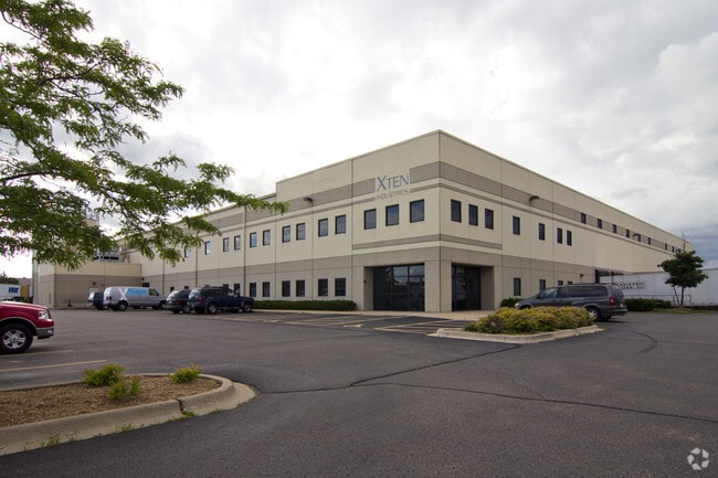
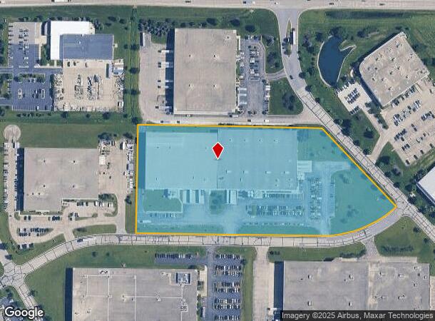
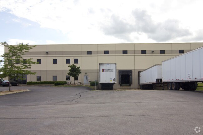
Property Record
9600 55Th St, Kenosha, WI 53144
NEARBY LISTINGS FOR SALE OR LEASE
Property Detail
9600 55Th St
Chicago-Naperville-Elgin, IL-IN-WI
Business P
08-222-32-310-141
LOTS 40 & 41 BUSINESS PARK OF KENOSHA BEING A REDIVISION OF PARCEL 1 CSM #1754 PT S 1/2 OF SEC 32 T2 R22 ANNEX ORD 10-94 EXC
Manufacturinglight
Kenosha
X
Wisconsin
55059C0183D
40-41
2024
9.02 AC
2024
Kenosha East
000601
Chicago
DEMOGRAPHICS near 9600 55Th St
1 Mile
3 Mile
5 Mile
2024 Total Population
2,547
27,134
87,319
2029 Population
2,509
27,132
86,572
Pop Growth 2024-2029
(1.49%)
(0.01%)
(0.86%)
Average Age
36
39
39
2024 Total Households
829
10,512
34,254
HH Growth 2024-2029
(1.57%)
0.00%
(0.89%)
Median Household Inc
$104,231
$79,744
$70,365
Avg Household Size
3.00
2.50
2.40
2024 Avg HH Vehicles
2.00
2.00
2.00
Median Home Value
$264,999
$260,829
$223,292
Median Year Built
1997
1995
1974
Nearby Places
Map Layers
Map Styles
 Street
 Aerial
- Restaurants
- Banks
- Shops
- Fitness
- Groceries
PUBLIC TRANSPORTATION
COMMUTER RAIL
Kenosha Station (Union Pacific North Line - Northeast Illinois Regional Commuter Railroad (Metra))
DRIVE
WALK
Distance
Kenosha Station (Union Pacific North Line - Northeast Illinois Regional Commuter Railroad (Metra))
13 min
5.6 mi
Sturtevant Amtrak Station (Hiawatha Service - Amtrak)
DRIVE
WALK
Distance
Sturtevant Amtrak Station (Hiawatha Service - Amtrak)
17 min
9.8 mi
AIRPORT
General Mitchell International
DRIVE
WALK
Distance
General Mitchell International
35 min
28.1 mi
Freight Ports
Port Milwaukee
DRIVE
WALK
Distance
Port Milwaukee
40 min
32.0 mi
Nearby Properties
Address
Land Use
TOTAL SIZE
Lot Size
Zoning
Address
Land Use
TOTAL SIZE
Lot Size
Zoning
1,015,740 SF
113.58 AC
C2
Address
Land Use
TOTAL SIZE
Lot Size
Zoning
2,565 SF
65.18 AC
Address
Land Use
TOTAL SIZE
Lot Size
Zoning
58.93 AC
Address
Land Use
TOTAL SIZE
Lot Size
Zoning
731,186 SF
81.94 AC
M2
Address
Land Use
TOTAL SIZE
Lot Size
Zoning
68.19 AC
Address
Land Use
TOTAL SIZE
Lot Size
Zoning
67.63 AC
FW
Address
Land Use
TOTAL SIZE
Lot Size
Zoning
3,886 SF
20.04 AC
Address
Land Use
TOTAL SIZE
Lot Size
Zoning
12,876 SF
30.13 AC
Address
Land Use
TOTAL SIZE
Lot Size
Zoning
795,471 SF
49.72 AC
Address
Land Use
TOTAL SIZE
Lot Size
Zoning
77.22 AC
Address
Land Use
TOTAL SIZE
Lot Size
Zoning
481,854 SF
84.10 AC
FW
Address
Land Use
TOTAL SIZE
Lot Size
Zoning
48.22 AC
Address
Land Use
TOTAL SIZE
Lot Size
Zoning
35.73 AC
M2
Address
Land Use
TOTAL SIZE
Lot Size
Zoning
57.67 AC
Address
Land Use
TOTAL SIZE
Lot Size
Zoning
44.09 AC
Address
Land Use
TOTAL SIZE
Lot Size
Zoning
606,510 SF
36.02 AC
Address
Land Use
TOTAL SIZE
Lot Size
Zoning
606,510 SF
32.10 AC
Address
Land Use
TOTAL SIZE
Lot Size
Zoning
1,467 SF
50.67 AC
Address
Land Use
TOTAL SIZE
Lot Size
Zoning
513,760 SF
48.61 AC
C1
Address
Land Use
TOTAL SIZE
Lot Size
Zoning
424,072 SF
29.14 AC
Address
Land Use
TOTAL SIZE
Lot Size
Zoning
16.01 AC
Address
Land Use
TOTAL SIZE
Lot Size
Zoning
30.04 AC
Address
Land Use
TOTAL SIZE
Lot Size
Zoning
47.82 AC
Address
Land Use
TOTAL SIZE
Lot Size
Zoning
850,230 SF
39.46 AC
M2
Address
Land Use
TOTAL SIZE
Lot Size
Zoning
626,520 SF
35.19 AC
M2
Address
Land Use
TOTAL SIZE
Lot Size
Zoning
13.10 AC
Address
Land Use
TOTAL SIZE
Lot Size
Zoning
20.33 AC
M2
Address
Land Use
TOTAL SIZE
Lot Size
Zoning
35,092 SF
26.34 AC
B2
Address
Land Use
TOTAL SIZE
Lot Size
Zoning
31,809 SF
11.36 AC
BASE
Address
Land Use
TOTAL SIZE
Lot Size
Zoning
50,145 SF
12.76 AC
The World's #1 Commercial Real Estate Marketplace
Connect with us
© 2025 CoStar Group
The information above has been obtained from sources believed reliable. While we do not doubt its accuracy we have not verified it and make no guarantee, warranty or representation about it. It is your responsibility to independently confirm its accuracy and completeness. Any projections, opinions, assumptions, or estimates used are for example only and do not represent the current or future performance of the property. The value of this transaction to you depends on tax and other factors which should be evaluated by your tax, financial, and legal advisors. You and your advisors should conduct a careful, independent investigation of the property to determine to your satisfaction the suitability of the property for your needs.