Property Record
9600 Ming Ave, Bakersfield, CA 93311
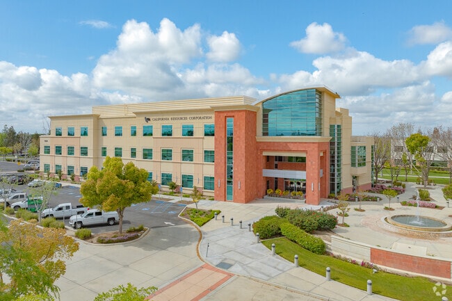

Property Detail
9600 Ming Ave
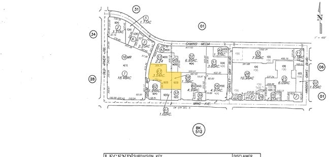
390-310-58-00-3
SECTION 5 , TOWNSHIP 30 , RANGE 27 , QUARTER SW
Officebuilding
KERN
CO
California
B and X Area of moderate flood hazard, usually the area between the limits of the 100-year and 500-year floods.
1.38 AC
2024
University Centre
2025
Bakersfield
002806
Bakersfield-Delano, CA
71,922 SF
NEARBY LISTINGS FOR SALE OR LEASE
DEMOGRAPHICS near 9600 Ming Ave
1 mile
3 mile
5 mile
2025 Total Population
8,457
104,292
244,653
2030 Population
8,494
106,137
248,834
Pop Growth 2025-2030
+ 0.44%
+ 1.77%
+ 1.71%
Average Age
41
38
37
2025 Total Households
3,361
36,680
81,793
HH Growth 2025-2030
+ 0.54%
+ 1.73%
+ 1.60%
Median Household Inc
$120,542
$97,090
$90,618
Avg Household Size
2.50
2.80
2.90
2025 Avg HH Vehicles
2.00
2.00
2.00
Median Home Value
$531,394
$415,251
$398,737
Median Year Built
1992
1990
1989
Nearby Places
Map Layers
Map Styles
 Street
 Aerial
Transit
 Traffic
 Biking
Places
Listings with unknown addresses are not visible on the map
- Restaurants
- Banks
- Shops
- Fitness
- Groceries
PUBLIC TRANSPORTATION
AIRPORT
Meadows Field
Drive
Walk
Distance
Meadows Field
23 min
10.9 mi
SALE & LEASE HISTORY
LISTING DATE
SALE/LEASE

Oct 09, 2017
For Lease
Jan 29, 2021
For Lease
Dec 17, 2021
For Lease
Aug 21, 2019
For Lease
Nearby Properties
Address
Land Use
TOTAL SIZE
Lot Size
Zoning
Address
Land Use
TOTAL SIZE
Lot Size
Zoning
587,976 SF
40.01 AC
M-2
Address
Land Use
TOTAL SIZE
Lot Size
Zoning
5,850 SF
10.96 AC
C2
Address
Land Use
TOTAL SIZE
Lot Size
Zoning
6,702 SF
18.75 AC
C-2
Address
Land Use
TOTAL SIZE
Lot Size
Zoning
354,000 SF
20 AC
M2
Address
Land Use
TOTAL SIZE
Lot Size
Zoning
14,529 SF
27.73 AC
R-2
Address
Land Use
TOTAL SIZE
Lot Size
Zoning
241,051 SF
18.48 AC
CO
Address
Land Use
TOTAL SIZE
Lot Size
Zoning
14,500 SF
33.82 AC
C2
Address
Land Use
TOTAL SIZE
Lot Size
Zoning
7,008 SF
46 AC
R1
Address
Land Use
TOTAL SIZE
Lot Size
Zoning
253,532 SF
14.69 AC
Address
Land Use
TOTAL SIZE
Lot Size
Zoning
138,559 SF
11.92 AC
C-2 PCD
Address
Land Use
TOTAL SIZE
Lot Size
Zoning
35,250 SF
10.33 AC
C-2 PCD
Address
Land Use
TOTAL SIZE
Lot Size
Zoning
149,197 SF
8.21 AC
PUD
Address
Land Use
TOTAL SIZE
Lot Size
Zoning
15,027 SF
17.72 AC
C-2
Address
Land Use
TOTAL SIZE
Lot Size
Zoning
51,517 SF
8.11 AC
CO
Address
Land Use
TOTAL SIZE
Lot Size
Zoning
37,760 SF
12.16 AC
R3
Address
Land Use
TOTAL SIZE
Lot Size
Zoning
99,368 SF
6.95 AC
CO
Address
Land Use
TOTAL SIZE
Lot Size
Zoning
233,512 SF
9.19 AC
R-3
Address
Land Use
TOTAL SIZE
Lot Size
Zoning
214,746 SF
14.91 AC
Address
Land Use
TOTAL SIZE
Lot Size
Zoning
138,923 SF
9.97 AC
C-2
Address
Land Use
TOTAL SIZE
Lot Size
Zoning
210,432 SF
13.52 AC
R-2
Address
Land Use
TOTAL SIZE
Lot Size
Zoning
93,274 SF
6.20 AC
R-2
Address
Land Use
TOTAL SIZE
Lot Size
Zoning
55,532 SF
4.18 AC
CO
Address
Land Use
TOTAL SIZE
Lot Size
Zoning
223,557 SF
21.31 AC
PCD
Address
Land Use
TOTAL SIZE
Lot Size
Zoning
83,388 SF
3.15 AC
Address
Land Use
TOTAL SIZE
Lot Size
Zoning
192,500 SF
11.48 AC
R-2
Address
Land Use
TOTAL SIZE
Lot Size
Zoning
83,936 SF
4.39 AC
R-2
Address
Land Use
TOTAL SIZE
Lot Size
Zoning
24,888 SF
5.75 AC
WM-R2
Address
Land Use
TOTAL SIZE
Lot Size
Zoning
51,666 SF
6.08 AC
C2
Address
Land Use
TOTAL SIZE
Lot Size
Zoning
63,702 SF
6.82 AC
WM C-O
The World's #1 Commercial Real Estate Marketplace
Connect with us
© 2026 CoStar Group
The information above has been obtained from sources believed reliable. While we do not doubt its accuracy we have not verified it and make no guarantee, warranty or representation about it. It is your responsibility to independently confirm its accuracy and completeness. Any projections, opinions, assumptions, or estimates used are for example only and do not represent the current or future performance of the property. The value of this transaction to you depends on tax and other factors which should be evaluated by your tax, financial, and legal advisors. You and your advisors should conduct a careful, independent investigation of the property to determine to your satisfaction the suitability of the property for your needs.