Property Record
9601 E Truman Rd, Independence, MO 64052
NEARBY LISTINGS FOR SALE OR LEASE
Property Detail
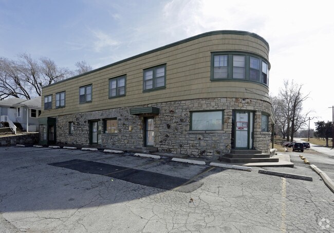
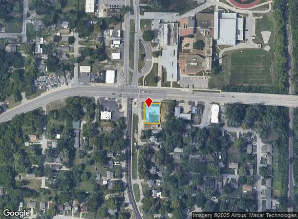
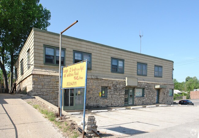
9601 E Truman Rd
Kansas City, MO-KS
Evanston
27-240-05-04-00-0-00-000
EVANSTON LOT 8
Officebuilding
Jackson
X
Missouri
29095C0277H
8
2024
0.28 AC
2025
East Jackson County
011800
Kansas City
8,224 SF
DEMOGRAPHICS near 9601 E Truman Rd
1 mile
3 mile
5 mile
2024 Total Population
10,044
59,077
161,445
2029 Population
10,104
59,326
162,358
Pop Growth 2024-2029
+ 0.60%
+ 0.42%
+ 0.57%
Average Age
38
39
38
2024 Total Households
4,093
23,524
63,176
HH Growth 2024-2029
+ 0.51%
+ 0.27%
+ 0.33%
Median Household Inc
$47,132
$45,066
$46,579
Avg Household Size
2.30
2.40
2.40
2024 Avg HH Vehicles
2.00
2.00
2.00
Median Home Value
$72,602
$99,290
$122,884
Median Year Built
1947
1952
1957
Nearby Places
Map Layers
Map Styles
 Street
 Aerial
Transit
 Traffic
 Biking
Places
Listings with unknown addresses are not visible on the map
- Restaurants
- Banks
- Shops
- Fitness
- Groceries
PUBLIC TRANSPORTATION
COMMUTER RAIL
Independence Amtrak Station (Lincoln Service Missouri River Runner - Amtrak, Missouri River Runner - Amtrak)
Drive
Walk
Distance
Independence Amtrak Station (Lincoln Service Missouri River Runner - Amtrak, Missouri River Runner - Amtrak)
6 min
2.6 mi
Kansas City (Lincoln Service Missouri River Runner - Amtrak, Missouri River Runner - Amtrak, Southwest Chief - Amtrak)
Drive
Walk
Distance
Kansas City (Lincoln Service Missouri River Runner - Amtrak, Missouri River Runner - Amtrak, Southwest Chief - Amtrak)
16 min
7.7 mi
AIRPORT
Kansas City International
Drive
Walk
Distance
Kansas City International
36 min
27.7 mi
Freight Ports
Tulsa Port Of Catoosa
Drive
Walk
Distance
Tulsa Port Of Catoosa
273 min
242.4 mi
Nearby Properties
Address
Land Use
TOTAL SIZE
Lot Size
Zoning
Address
Land Use
TOTAL SIZE
Lot Size
Zoning
162,095 SF
Address
Land Use
TOTAL SIZE
Lot Size
Zoning
7,962 SF
7.80 AC
Address
Land Use
TOTAL SIZE
Lot Size
Zoning
253,472 SF
396.83 AC
Address
Land Use
TOTAL SIZE
Lot Size
Zoning
44,274 SF
9.40 AC
Address
Land Use
TOTAL SIZE
Lot Size
Zoning
32,777 SF
21.40 AC
Address
Land Use
TOTAL SIZE
Lot Size
Zoning
123,305 SF
15.51 AC
Address
Land Use
TOTAL SIZE
Lot Size
Zoning
213,615 SF
15.50 AC
Address
Land Use
TOTAL SIZE
Lot Size
Zoning
74,801 SF
8.93 AC
Address
Land Use
TOTAL SIZE
Lot Size
Zoning
138,353 SF
23.03 AC
Address
Land Use
TOTAL SIZE
Lot Size
Zoning
157,666 SF
18.54 AC
Address
Land Use
TOTAL SIZE
Lot Size
Zoning
139,713 SF
15.70 AC
Address
Land Use
TOTAL SIZE
Lot Size
Zoning
13,227 SF
287 AC
Address
Land Use
TOTAL SIZE
Lot Size
Zoning
76,410 SF
49.60 AC
Address
Land Use
TOTAL SIZE
Lot Size
Zoning
71,339 SF
0.68 AC
Address
Land Use
TOTAL SIZE
Lot Size
Zoning
113,667 SF
6.31 AC
Address
Land Use
TOTAL SIZE
Lot Size
Zoning
55,985 SF
20.93 AC
Address
Land Use
TOTAL SIZE
Lot Size
Zoning
70,555 SF
32.97 AC
Address
Land Use
TOTAL SIZE
Lot Size
Zoning
229,425 SF
15.68 AC
Address
Land Use
TOTAL SIZE
Lot Size
Zoning
286,490 SF
37.30 AC
Address
Land Use
TOTAL SIZE
Lot Size
Zoning
9,768 SF
0.87 AC
Address
Land Use
TOTAL SIZE
Lot Size
Zoning
43,504 SF
Address
Land Use
TOTAL SIZE
Lot Size
Zoning
129,315 SF
15.90 AC
Address
Land Use
TOTAL SIZE
Lot Size
Zoning
79,609 SF
2.91 AC
Address
Land Use
TOTAL SIZE
Lot Size
Zoning
71,368 SF
5.64 AC
Address
Land Use
TOTAL SIZE
Lot Size
Zoning
39,120 SF
1.87 AC
Address
Land Use
TOTAL SIZE
Lot Size
Zoning
57,732 SF
22.42 AC
Address
Land Use
TOTAL SIZE
Lot Size
Zoning
180,316 SF
8.49 AC
Address
Land Use
TOTAL SIZE
Lot Size
Zoning
50,900 SF
13.80 AC
Address
Land Use
TOTAL SIZE
Lot Size
Zoning
58,946 SF
0.98 AC
Address
Land Use
TOTAL SIZE
Lot Size
Zoning
621,400 SF
The World's #1 Commercial Real Estate Marketplace
Connect with us
© 2026 CoStar Group
The information above has been obtained from sources believed reliable. While we do not doubt its accuracy we have not verified it and make no guarantee, warranty or representation about it. It is your responsibility to independently confirm its accuracy and completeness. Any projections, opinions, assumptions, or estimates used are for example only and do not represent the current or future performance of the property. The value of this transaction to you depends on tax and other factors which should be evaluated by your tax, financial, and legal advisors. You and your advisors should conduct a careful, independent investigation of the property to determine to your satisfaction the suitability of the property for your needs.