Property Record
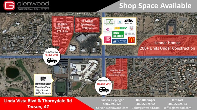
9605 N Thornydale Rd, Tucson, AZ 85742


NEARBY LISTINGS FOR SALE OR LEASE
-
-
View all Tucson listings for lease on LoopNet.com
Property Detail
9605 N Thornydale Rd
224-46-2710
IRR CTRL PTN E2 SE4 SE4 5.55 AC SEC 18-12-13
Stripcommercialcenter
Pima
X
Arizona
04019C1070L
62
2025
5.55 AC
2025
Northwest Tucson
004644
Tucson
62,623 SF
Tucson, AZ
DEMOGRAPHICS near 9605 N Thornydale Rd
1 Mile
3 Mile
5 Mile
2024 Total Population
5,816
49,079
119,882
2029 Population
6,086
50,983
124,091
Pop Growth 2024-2029
+ 4.64%
+ 3.88%
+ 3.51%
Average Age
40
41
42
2024 Total Households
2,304
18,956
48,468
HH Growth 2024-2029
+ 4.56%
+ 3.88%
+ 3.50%
Median Household Inc
$81,584
$85,595
$85,447
Avg Household Size
2.50
2.50
2.40
2024 Avg HH Vehicles
2.00
2.00
2.00
Median Home Value
$268,155
$277,511
$308,996
Median Year Built
1994
1992
1993
Nearby Places
Map Layers
Map Styles
 Street
 Aerial
- Restaurants
- Banks
- Shops
- Fitness
- Groceries
PUBLIC TRANSPORTATION
AIRPORT
Tucson International
DRIVE
WALK
Distance
Tucson International
33 min
21.4 mi
Freight Ports
Port of San Diego
DRIVE
WALK
Distance
Port of San Diego
425 min
398.5 mi
SALE & LEASE HISTORY
LISTING DATE
SALE/LEASE

Sep 24, 2016
For Lease
May 24, 2022
For Lease
Mar 11, 2020
For Lease
Aug 09, 2019
For Sale
Nearby Properties
Address
Land Use
TOTAL SIZE
Lot Size
Zoning
Address
Land Use
TOTAL SIZE
Lot Size
Zoning
315,816 SF
35.57 AC
SR
Address
Land Use
TOTAL SIZE
Lot Size
Zoning
297,779 SF
13.59 AC
Address
Land Use
TOTAL SIZE
Lot Size
Zoning
390,339 SF
35.51 AC
Address
Land Use
TOTAL SIZE
Lot Size
Zoning
131,575 SF
25.97 AC
SR
Address
Land Use
TOTAL SIZE
Lot Size
Zoning
129,641 SF
36.72 AC
R1144
Address
Land Use
TOTAL SIZE
Lot Size
Zoning
232,740 SF
177.79 AC
Address
Land Use
TOTAL SIZE
Lot Size
Zoning
144,010 SF
17.12 AC
R1144
Address
Land Use
TOTAL SIZE
Lot Size
Zoning
203,101 SF
11.35 AC
F
Address
Land Use
TOTAL SIZE
Lot Size
Zoning
146,066 SF
20 AC
SR
Address
Land Use
TOTAL SIZE
Lot Size
Zoning
190,257 SF
6.68 AC
Address
Land Use
TOTAL SIZE
Lot Size
Zoning
226,937 SF
10.64 AC
CR5
Address
Land Use
TOTAL SIZE
Lot Size
Zoning
63,761 SF
19 AC
SR
Address
Land Use
TOTAL SIZE
Lot Size
Zoning
108,380 SF
11.36 AC
F
Address
Land Use
TOTAL SIZE
Lot Size
Zoning
230,464 SF
14.16 AC
CR5
Address
Land Use
TOTAL SIZE
Lot Size
Zoning
108,380 SF
10.95 AC
Address
Land Use
TOTAL SIZE
Lot Size
Zoning
128,129 SF
10.63 AC
CR5
Address
Land Use
TOTAL SIZE
Lot Size
Zoning
64,555 SF
9.11 AC
SR
Address
Land Use
TOTAL SIZE
Lot Size
Zoning
Address
Land Use
TOTAL SIZE
Lot Size
Zoning
152,627 SF
9.64 AC
CR5
Address
Land Use
TOTAL SIZE
Lot Size
Zoning
84,151 SF
14.54 AC
SR
Address
Land Use
TOTAL SIZE
Lot Size
Zoning
60,163 SF
2.97 AC
Address
Land Use
TOTAL SIZE
Lot Size
Zoning
67,357 SF
9.99 AC
SR
Address
Land Use
TOTAL SIZE
Lot Size
Zoning
116,386 SF
8.36 AC
TR
Address
Land Use
TOTAL SIZE
Lot Size
Zoning
56,100 SF
9.55 AC
SR
Address
Land Use
TOTAL SIZE
Lot Size
Zoning
95,388 SF
11.69 AC
F
Address
Land Use
TOTAL SIZE
Lot Size
Zoning
102,469 SF
2.44 AC
Address
Land Use
TOTAL SIZE
Lot Size
Zoning
59,737 SF
12.01 AC
SR
Address
Land Use
TOTAL SIZE
Lot Size
Zoning
202,860 SF
8.51 AC
CR5
Address
Land Use
TOTAL SIZE
Lot Size
Zoning
87,005 SF
6.46 AC
F
Address
Land Use
TOTAL SIZE
Lot Size
Zoning
136,714 SF
8.27 AC
CR5
The World's #1 Commercial Real Estate Marketplace
Connect with us
© 2025 CoStar Group
The information above has been obtained from sources believed reliable. While we do not doubt its accuracy we have not verified it and make no guarantee, warranty or representation about it. It is your responsibility to independently confirm its accuracy and completeness. Any projections, opinions, assumptions, or estimates used are for example only and do not represent the current or future performance of the property. The value of this transaction to you depends on tax and other factors which should be evaluated by your tax, financial, and legal advisors. You and your advisors should conduct a careful, independent investigation of the property to determine to your satisfaction the suitability of the property for your needs.