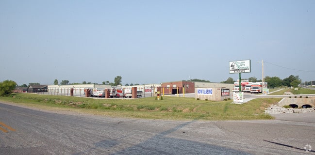
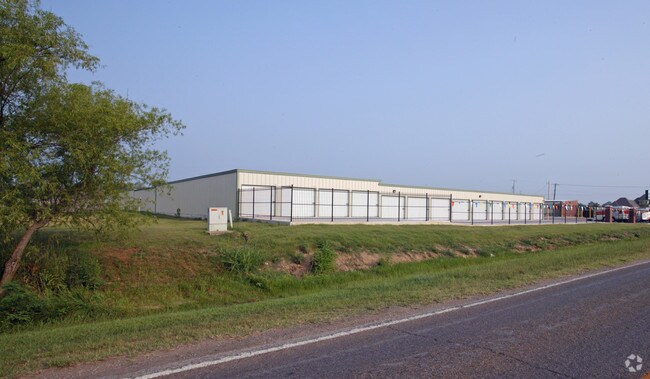
Property Record
9610 E 116Th St N, Owasso, OK 74055

NEARBY LISTINGS FOR SALE OR LEASE
Property Detail
9610 E 116Th St N
Tulsa, OK
Hillside Estates
57280-13-12-00020
LT 1 LESS BEG NECR LT1 BLK1 HILLSIDE ESTATES TH S40 NW42.42 W375 N10 E405 POB BLK 1
Publicstorage
Tulsa
AE
Oklahoma
40131C0250H
1
2025
2.46 AC
2025
Northeast
005808
Tulsa
35,950 SF
DEMOGRAPHICS near 9610 E 116Th St N
1 Mile
3 Mile
5 Mile
2024 Total Population
3,327
23,923
62,189
2029 Population
3,422
24,849
64,858
Pop Growth 2024-2029
+ 2.86%
+ 3.87%
+ 4.29%
Average Age
36
37
38
2024 Total Households
1,189
8,929
23,114
HH Growth 2024-2029
+ 2.94%
+ 3.88%
+ 4.29%
Median Household Inc
$93,258
$79,236
$74,947
Avg Household Size
2.80
2.70
2.70
2024 Avg HH Vehicles
2.00
2.00
2.00
Median Home Value
$172,628
$207,319
$215,033
Median Year Built
2000
2003
1999
Nearby Places
Map Layers
Map Styles
 Street
 Aerial
- Restaurants
- Banks
- Shops
- Fitness
- Groceries
PUBLIC TRANSPORTATION
AIRPORT
Tulsa International
DRIVE
WALK
Distance
Tulsa International
20 min
11.7 mi
Freight Ports
DRIVE
WALK
Distance
24 min
14.5 mi
Nearby Properties
Address
Land Use
TOTAL SIZE
Lot Size
Zoning
Address
Land Use
TOTAL SIZE
Lot Size
Zoning
299,471 SF
64.32 AC
AG
Address
Land Use
TOTAL SIZE
Lot Size
Zoning
111,792 SF
12.43 AC
OM
Address
Land Use
TOTAL SIZE
Lot Size
Zoning
47,798 SF
5.13 AC
CS
Address
Land Use
TOTAL SIZE
Lot Size
Zoning
115,952 SF
19.30 AC
RS3
Address
Land Use
TOTAL SIZE
Lot Size
Zoning
138,427 SF
8.90 AC
OM
Address
Land Use
TOTAL SIZE
Lot Size
Zoning
105,098 SF
18.22 AC
RS2
Address
Land Use
TOTAL SIZE
Lot Size
Zoning
43,882 SF
10 AC
AG
Address
Land Use
TOTAL SIZE
Lot Size
Zoning
270,386 SF
14.65 AC
RM
Address
Land Use
TOTAL SIZE
Lot Size
Zoning
246,823 SF
12.77 AC
Address
Land Use
TOTAL SIZE
Lot Size
Zoning
266,778 SF
12.26 AC
CN
Address
Land Use
TOTAL SIZE
Lot Size
Zoning
101,776 SF
9.96 AC
CS
Address
Land Use
TOTAL SIZE
Lot Size
Zoning
40,100 SF
4.36 AC
IM
Address
Land Use
TOTAL SIZE
Lot Size
Zoning
40,822 SF
11.39 AC
AG
Address
Land Use
TOTAL SIZE
Lot Size
Zoning
40,206 SF
3.72 AC
RS3
Address
Land Use
TOTAL SIZE
Lot Size
Zoning
178,815 SF
18.21 AC
CS
Address
Land Use
TOTAL SIZE
Lot Size
Zoning
133,301 SF
21.09 AC
RS3
Address
Land Use
TOTAL SIZE
Lot Size
Zoning
24,435 SF
4.41 AC
RE
Address
Land Use
TOTAL SIZE
Lot Size
Zoning
208,326 SF
16.36 AC
CS
Address
Land Use
TOTAL SIZE
Lot Size
Zoning
140,358 SF
5.10 AC
RM1
Address
Land Use
TOTAL SIZE
Lot Size
Zoning
3,679 SF
33.74 AC
AG
Address
Land Use
TOTAL SIZE
Lot Size
Zoning
31,781 SF
4.60 AC
AG
Address
Land Use
TOTAL SIZE
Lot Size
Zoning
54,123 SF
1.85 AC
CG
Address
Land Use
TOTAL SIZE
Lot Size
Zoning
103,300 SF
13.81 AC
CS
Address
Land Use
TOTAL SIZE
Lot Size
Zoning
33,157 SF
3.82 AC
AGR
Address
Land Use
TOTAL SIZE
Lot Size
Zoning
8,334 SF
46.11 AC
AG
Address
Land Use
TOTAL SIZE
Lot Size
Zoning
102,100 SF
10.55 AC
CS
Address
Land Use
TOTAL SIZE
Lot Size
Zoning
114,618 SF
7.02 AC
RM1
Address
Land Use
TOTAL SIZE
Lot Size
Zoning
113.74 AC
AG
Address
Land Use
TOTAL SIZE
Lot Size
Zoning
135,266 SF
12.82 AC
CS
Address
Land Use
TOTAL SIZE
Lot Size
Zoning
136,762 SF
20.49 AC
CS
The World's #1 Commercial Real Estate Marketplace
Connect with us
© 2026 CoStar Group
The information above has been obtained from sources believed reliable. While we do not doubt its accuracy we have not verified it and make no guarantee, warranty or representation about it. It is your responsibility to independently confirm its accuracy and completeness. Any projections, opinions, assumptions, or estimates used are for example only and do not represent the current or future performance of the property. The value of this transaction to you depends on tax and other factors which should be evaluated by your tax, financial, and legal advisors. You and your advisors should conduct a careful, independent investigation of the property to determine to your satisfaction the suitability of the property for your needs.