Property Record
9615 Louetta Rd, Spring, TX 77379
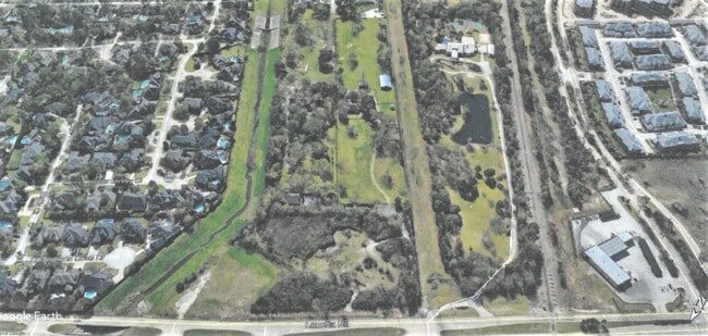
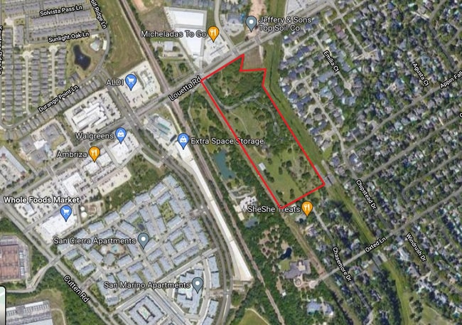
This Property Is For Sale
Property Detail
9615 Louetta Rd
Houston-Pasadena-The Woodlands, TX
TRS 34 & 34G ABST 618 B PAGE
0440420000495
Harris
Agriculturalland
Texas
B and X Area of moderate flood hazard, usually the area between the limits of the 100-year and 500-year floods.
2.70 AC
2024
FM 1960/Hwy 249
2025
Houston
554002
NEARBY LISTINGS FOR SALE OR LEASE
DEMOGRAPHICS near 9615 Louetta Rd
1 mile
3 mile
5 mile
2025 Total Population
14,761
106,280
288,057
2030 Population
15,777
112,704
306,140
Pop Growth 2025-2030
+ 6.88%
+ 6.04%
+ 6.28%
Average Age
39
40
38
2025 Total Households
5,740
40,518
102,308
HH Growth 2025-2030
+ 7.30%
+ 6.27%
+ 6.49%
Median Household Inc
$91,344
$84,393
$89,635
Avg Household Size
2.50
2.60
2.80
2025 Avg HH Vehicles
2.00
2.00
2.00
Median Home Value
$295,290
$333,555
$327,648
Median Year Built
1999
1994
1996
Nearby Places
Map Layers
Map Styles
 Street
 Aerial
Transit
 Traffic
 Biking
Places
Listings with unknown addresses are not visible on the map
- Restaurants
- Banks
- Shops
- Fitness
- Groceries
PUBLIC TRANSPORTATION
AIRPORT
George Bush Intcntl/Houston
Drive
Walk
Distance
George Bush Intcntl/Houston
28 min
20.8 mi
William P Hobby
Drive
Walk
Distance
William P Hobby
56 min
35.9 mi
Freight Ports
Port of Houston
Drive
Walk
Distance
Port of Houston
48 min
31.4 mi
Nearby Properties
Address
Land Use
TOTAL SIZE
Lot Size
Zoning
Address
Land Use
TOTAL SIZE
Lot Size
Zoning
1,648,539 SF
28.70 AC
Address
Land Use
TOTAL SIZE
Lot Size
Zoning
339,067 SF
34.40 AC
Address
Land Use
TOTAL SIZE
Lot Size
Zoning
427,317 SF
14.16 AC
Address
Land Use
TOTAL SIZE
Lot Size
Zoning
1,073,104 SF
4.74 AC
Address
Land Use
TOTAL SIZE
Lot Size
Zoning
445,343 SF
37.78 AC
Address
Land Use
TOTAL SIZE
Lot Size
Zoning
227,400 SF
2.77 AC
Address
Land Use
TOTAL SIZE
Lot Size
Zoning
386,754 SF
17.99 AC
Address
Land Use
TOTAL SIZE
Lot Size
Zoning
507,035 SF
24.90 AC
Address
Land Use
TOTAL SIZE
Lot Size
Zoning
263,640 SF
36.62 AC
Address
Land Use
TOTAL SIZE
Lot Size
Zoning
551,524 SF
10.06 AC
Address
Land Use
TOTAL SIZE
Lot Size
Zoning
339,477 SF
13.54 AC
Address
Land Use
TOTAL SIZE
Lot Size
Zoning
351,343 SF
12.82 AC
Address
Land Use
TOTAL SIZE
Lot Size
Zoning
267,094 SF
14.76 AC
Address
Land Use
TOTAL SIZE
Lot Size
Zoning
486,739 SF
19.92 AC
Address
Land Use
TOTAL SIZE
Lot Size
Zoning
262,163 SF
8.63 AC
Address
Land Use
TOTAL SIZE
Lot Size
Zoning
405,225 SF
18.34 AC
Address
Land Use
TOTAL SIZE
Lot Size
Zoning
423,472 SF
28.91 AC
Address
Land Use
TOTAL SIZE
Lot Size
Zoning
469,370 SF
19.39 AC
Address
Land Use
TOTAL SIZE
Lot Size
Zoning
256,761 SF
8.78 AC
Address
Land Use
TOTAL SIZE
Lot Size
Zoning
433,984 SF
17.82 AC
Address
Land Use
TOTAL SIZE
Lot Size
Zoning
368,361 SF
23.95 AC
Address
Land Use
TOTAL SIZE
Lot Size
Zoning
260,253 SF
7.46 AC
Address
Land Use
TOTAL SIZE
Lot Size
Zoning
377,188 SF
16.80 AC
Address
Land Use
TOTAL SIZE
Lot Size
Zoning
371,761 SF
12.71 AC
Address
Land Use
TOTAL SIZE
Lot Size
Zoning
237,742 SF
13.80 AC
Address
Land Use
TOTAL SIZE
Lot Size
Zoning
181,542 SF
8 AC
Address
Land Use
TOTAL SIZE
Lot Size
Zoning
308,141 SF
17.64 AC
Address
Land Use
TOTAL SIZE
Lot Size
Zoning
335,954 SF
35.27 AC
Address
Land Use
TOTAL SIZE
Lot Size
Zoning
80,004 SF
4.41 AC
Address
Land Use
TOTAL SIZE
Lot Size
Zoning
300,080 SF
13.86 AC
The World's #1 Commercial Real Estate Marketplace
Connect with us
© 2026 CoStar Group
The information above has been obtained from sources believed reliable. While we do not doubt its accuracy we have not verified it and make no guarantee, warranty or representation about it. It is your responsibility to independently confirm its accuracy and completeness. Any projections, opinions, assumptions, or estimates used are for example only and do not represent the current or future performance of the property. The value of this transaction to you depends on tax and other factors which should be evaluated by your tax, financial, and legal advisors. You and your advisors should conduct a careful, independent investigation of the property to determine to your satisfaction the suitability of the property for your needs.