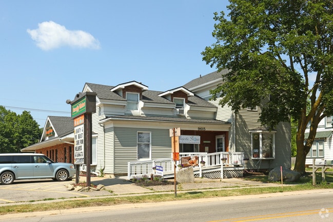
Property Record
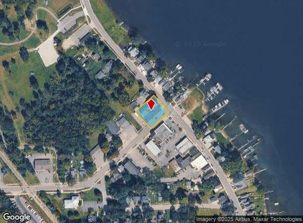
9615 Main St, Whitmore Lake, MI 48189


NEARBY LISTINGS FOR SALE OR LEASE
-
-
View all Whitmore Lake listings for lease on LoopNet.com
Property Detail
9615 Main St
02-05-253-005
OLD SID - B 02-005-070-00 NO 5-62 COM AT W 1/4 POST OF SEC, THN 2 DEG 30' W 1.63 CHNS IN THE W LINE OF SEC, TH N 47 DEG 45' E
Commercialnec
Washtenaw
X
Michigan
26161C0092E
0.43 AC
2025
Washtenaw E of 23
2025
Detroit
465002
Ann Arbor, MI
3,090 SF
DEMOGRAPHICS near 9615 Main St
1 Mile
3 Mile
5 Mile
2024 Total Population
4,613
13,710
32,048
2029 Population
4,645
13,863
32,580
Pop Growth 2024-2029
+ 0.69%
+ 1.12%
+ 1.66%
Average Age
40
42
43
2024 Total Households
1,992
5,477
12,493
HH Growth 2024-2029
+ 0.60%
+ 1.00%
+ 1.59%
Median Household Inc
$70,308
$80,165
$96,798
Avg Household Size
2.30
2.40
2.50
2024 Avg HH Vehicles
2.00
2.00
2.00
Median Home Value
$218,664
$296,062
$336,839
Median Year Built
1991
1989
1989
Nearby Places
Map Layers
Map Styles
 Street
 Aerial
- Restaurants
- Banks
- Shops
- Fitness
- Groceries
PUBLIC TRANSPORTATION
AIRPORT
Detroit Metro Wayne County
DRIVE
WALK
Distance
Detroit Metro Wayne County
50 min
39.3 mi
SALE & LEASE HISTORY
LISTING DATE
SALE/LEASE

Oct 12, 2018
For Sale
Nov 01, 2018
For Lease
May 12, 2020
For Sale
May 01, 2023
For Lease
Mar 13, 2019
For Lease
Mar 06, 2021
For Lease
Feb 24, 2021
For Sale
Feb 22, 2023
For Sale
Dec 15, 2023
For Lease
Dec 15, 2020
For Lease
Nearby Properties
Address
Land Use
TOTAL SIZE
Lot Size
Zoning
Address
Land Use
TOTAL SIZE
Lot Size
Zoning
301,472 SF
72.80 AC
LI
Address
Land Use
TOTAL SIZE
Lot Size
Zoning
291,012 SF
70.69 AC
P.U.D
Address
Land Use
TOTAL SIZE
Lot Size
Zoning
136,172 SF
90.76 AC
PUD-VMU-2
Address
Land Use
TOTAL SIZE
Lot Size
Zoning
291,012 SF
Address
Land Use
TOTAL SIZE
Lot Size
Zoning
301,472 SF
62.80 AC
LI
Address
Land Use
TOTAL SIZE
Lot Size
Zoning
893 SF
130.95 AC
MHP-MOBIL
Address
Land Use
TOTAL SIZE
Lot Size
Zoning
32,964 SF
11.95 AC
MR-MULTIPL
Address
Land Use
TOTAL SIZE
Lot Size
Zoning
10,839 SF
9.52 AC
MR-MULTIPL
Address
Land Use
TOTAL SIZE
Lot Size
Zoning
101,120 SF
12.30 AC
RM
Address
Land Use
TOTAL SIZE
Lot Size
Zoning
1,970 SF
37.72 AC
MHP
Address
Land Use
TOTAL SIZE
Lot Size
Zoning
103,900 SF
26.88 AC
GI
Address
Land Use
TOTAL SIZE
Lot Size
Zoning
62,548 SF
4.28 AC
GC-GEN COM
Address
Land Use
TOTAL SIZE
Lot Size
Zoning
50 AC
MHP
Address
Land Use
TOTAL SIZE
Lot Size
Zoning
133.34 AC
PUD-VMU-2
Address
Land Use
TOTAL SIZE
Lot Size
Zoning
17.83 AC
HC
Address
Land Use
TOTAL SIZE
Lot Size
Zoning
128 AC
R3
Address
Land Use
TOTAL SIZE
Lot Size
Zoning
70.16 AC
PSC-PLANNE
Address
Land Use
TOTAL SIZE
Lot Size
Zoning
73,711 SF
6.77 AC
LI
Address
Land Use
TOTAL SIZE
Lot Size
Zoning
46,647 SF
7.16 AC
GB
Address
Land Use
TOTAL SIZE
Lot Size
Zoning
35.74 AC
GC-GEN COM
Address
Land Use
TOTAL SIZE
Lot Size
Zoning
52,800 SF
8.10 AC
LB
Address
Land Use
TOTAL SIZE
Lot Size
Zoning
47,088 SF
7.72 AC
RM
Address
Land Use
TOTAL SIZE
Lot Size
Zoning
105,868 SF
37.75 AC
GI
Address
Land Use
TOTAL SIZE
Lot Size
Zoning
52,100 SF
10.36 AC
GI
Address
Land Use
TOTAL SIZE
Lot Size
Zoning
29,928 SF
7 AC
VC
Address
Land Use
TOTAL SIZE
Lot Size
Zoning
24,500 SF
12.15 AC
GI
Address
Land Use
TOTAL SIZE
Lot Size
Zoning
12,942 SF
1.52 AC
VC
Address
Land Use
TOTAL SIZE
Lot Size
Zoning
3,800 SF
5.53 AC
GC-GEN COM
Address
Land Use
TOTAL SIZE
Lot Size
Zoning
45,800 SF
3.23 AC
LI
Address
Land Use
TOTAL SIZE
Lot Size
Zoning
26,392 SF
13.15 AC
GI
The World's #1 Commercial Real Estate Marketplace
Connect with us
© 2025 CoStar Group
The information above has been obtained from sources believed reliable. While we do not doubt its accuracy we have not verified it and make no guarantee, warranty or representation about it. It is your responsibility to independently confirm its accuracy and completeness. Any projections, opinions, assumptions, or estimates used are for example only and do not represent the current or future performance of the property. The value of this transaction to you depends on tax and other factors which should be evaluated by your tax, financial, and legal advisors. You and your advisors should conduct a careful, independent investigation of the property to determine to your satisfaction the suitability of the property for your needs.