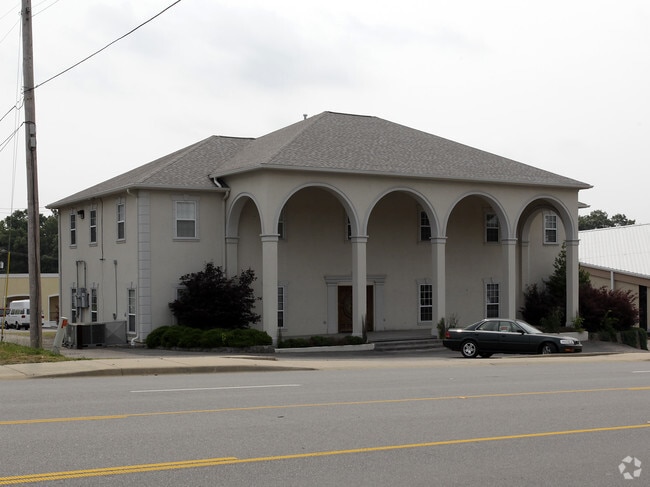
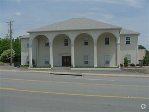
Property Record
9618 Highway 107, Sherwood, AR 72120

NEARBY LISTINGS FOR SALE OR LEASE
Property Detail
9618 Highway 107
Little Rock-North Little Rock-Conway, AR
North Hills Church Addn
22S-001-36-001-00
LOT 1R FORMERLY PLATTED AS LOT 1 NORTH HILLS CHURCH ADDN 31 3N 11W
Religious
Pulaski
X
Arkansas
05119C0355G
1r
2025
4.15 AC
2025
Outlying Pulaski County
003714
Little Rock/N Little Rock
41,848 SF
DEMOGRAPHICS near 9618 Highway 107
1 Mile
3 Mile
5 Mile
2024 Total Population
5,640
39,417
78,753
2029 Population
5,582
39,005
78,347
Pop Growth 2024-2029
(1.03%)
(1.05%)
(0.52%)
Average Age
41
41
40
2024 Total Households
2,425
16,583
33,606
HH Growth 2024-2029
(1.15%)
(1.11%)
(0.50%)
Median Household Inc
$67,217
$72,790
$59,692
Avg Household Size
2.30
2.30
2.30
2024 Avg HH Vehicles
2.00
2.00
2.00
Median Home Value
$185,268
$191,627
$172,986
Median Year Built
1985
1982
1977
Nearby Places
Map Layers
Map Styles
 Street
 Aerial
- Restaurants
- Banks
- Shops
- Fitness
- Groceries
PUBLIC TRANSPORTATION
COMMUTER RAIL
Little Rock Union Station (Texas Eagle - Amtrak)
DRIVE
WALK
Distance
Little Rock Union Station (Texas Eagle - Amtrak)
15 min
8.4 mi
AIRPORT
Bill and Hillary Clinton Ntl/Adams Field
DRIVE
WALK
Distance
Bill and Hillary Clinton Ntl/Adams Field
21 min
12.6 mi
Freight Ports
Port of Shreveport
DRIVE
WALK
Distance
Port of Shreveport
263 min
241.5 mi
Nearby Properties
Address
Land Use
TOTAL SIZE
Lot Size
Zoning
Address
Land Use
TOTAL SIZE
Lot Size
Zoning
316,927 SF
50.65 AC
Address
Land Use
TOTAL SIZE
Lot Size
Zoning
72,806 SF
10.95 AC
Address
Land Use
TOTAL SIZE
Lot Size
Zoning
195,404 SF
25.19 AC
Address
Land Use
TOTAL SIZE
Lot Size
Zoning
17,352 SF
42.55 AC
Address
Land Use
TOTAL SIZE
Lot Size
Zoning
36,934 SF
15.06 AC
Address
Land Use
TOTAL SIZE
Lot Size
Zoning
75,462 SF
5.33 AC
Address
Land Use
TOTAL SIZE
Lot Size
Zoning
219,330 SF
24.14 AC
Address
Land Use
TOTAL SIZE
Lot Size
Zoning
83,431 SF
10.99 AC
Address
Land Use
TOTAL SIZE
Lot Size
Zoning
49,995 SF
12.92 AC
Address
Land Use
TOTAL SIZE
Lot Size
Zoning
72,157 SF
9.45 AC
Address
Land Use
TOTAL SIZE
Lot Size
Zoning
31,644 SF
Address
Land Use
TOTAL SIZE
Lot Size
Zoning
56,643 SF
9.46 AC
Address
Land Use
TOTAL SIZE
Lot Size
Zoning
28,947 SF
8.29 AC
Address
Land Use
TOTAL SIZE
Lot Size
Zoning
8,520 SF
11.30 AC
Address
Land Use
TOTAL SIZE
Lot Size
Zoning
49,393 SF
5.31 AC
Address
Land Use
TOTAL SIZE
Lot Size
Zoning
45,500 SF
12.07 AC
Address
Land Use
TOTAL SIZE
Lot Size
Zoning
100,163 SF
15.51 AC
Address
Land Use
TOTAL SIZE
Lot Size
Zoning
145,604 SF
12.62 AC
Address
Land Use
TOTAL SIZE
Lot Size
Zoning
32,788 SF
3.99 AC
Address
Land Use
TOTAL SIZE
Lot Size
Zoning
33,597 SF
Address
Land Use
TOTAL SIZE
Lot Size
Zoning
141,664 SF
12.21 AC
Address
Land Use
TOTAL SIZE
Lot Size
Zoning
44,092 SF
7.97 AC
Address
Land Use
TOTAL SIZE
Lot Size
Zoning
3,306 SF
8.33 AC
Address
Land Use
TOTAL SIZE
Lot Size
Zoning
54,401 SF
1.68 AC
Address
Land Use
TOTAL SIZE
Lot Size
Zoning
40,065 SF
8.26 AC
Address
Land Use
TOTAL SIZE
Lot Size
Zoning
26,334 SF
4.51 AC
Address
Land Use
TOTAL SIZE
Lot Size
Zoning
75,064 SF
5.78 AC
Address
Land Use
TOTAL SIZE
Lot Size
Zoning
35,645 SF
7.97 AC
Address
Land Use
TOTAL SIZE
Lot Size
Zoning
7,975 SF
3.96 AC
Address
Land Use
TOTAL SIZE
Lot Size
Zoning
9,222 SF
6.58 AC
The World's #1 Commercial Real Estate Marketplace
Connect with us
© 2026 CoStar Group
The information above has been obtained from sources believed reliable. While we do not doubt its accuracy we have not verified it and make no guarantee, warranty or representation about it. It is your responsibility to independently confirm its accuracy and completeness. Any projections, opinions, assumptions, or estimates used are for example only and do not represent the current or future performance of the property. The value of this transaction to you depends on tax and other factors which should be evaluated by your tax, financial, and legal advisors. You and your advisors should conduct a careful, independent investigation of the property to determine to your satisfaction the suitability of the property for your needs.