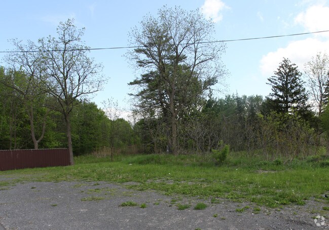
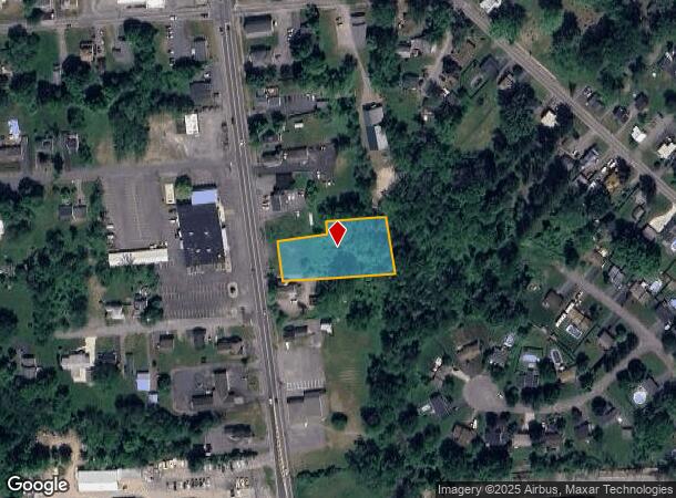
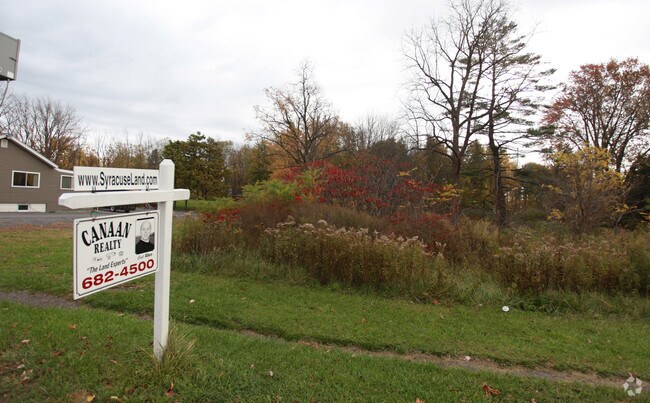
Property Record
9620 Brewerton Rd, Brewerton, NY 13029
NEARBY LISTINGS FOR SALE OR LEASE
Property Detail
9620 Brewerton Rd
Syracuse, NY
FL 10(BREWERTON VILL BLKS 58) 117
312289-111-000-0004-002-001-0000
Onondaga
Residentialacreage
New York
X
2.001
36067C0082F
0.72 AC
2025
NE Outer Onondaga County
2024
Syracuse
010200
DEMOGRAPHICS near 9620 Brewerton Rd
1 Mile
3 Mile
5 Mile
2024 Total Population
3,511
7,262
29,388
2029 Population
3,408
7,111
28,733
Pop Growth 2024-2029
(2.93%)
(2.08%)
(2.23%)
Average Age
41
43
42
2024 Total Households
1,489
3,005
11,694
HH Growth 2024-2029
(3.16%)
(2.30%)
(2.38%)
Median Household Inc
$73,638
$79,230
$94,636
Avg Household Size
2.30
2.30
2.50
2024 Avg HH Vehicles
2.00
2.00
2.00
Median Home Value
$187,424
$210,854
$193,511
Median Year Built
1983
1981
1983
Nearby Places
- Restaurants
- Banks
- Shops
- Fitness
- Groceries
PUBLIC TRANSPORTATION
AIRPORT
Syracuse Hancock International
DRIVE
WALK
Distance
Syracuse Hancock International
16 min
11.1 mi
Freight Ports
Albany, NY Port
DRIVE
WALK
Distance
Albany, NY Port
180 min
151.5 mi
Nearby Properties
Address
Land Use
TOTAL SIZE
Lot Size
Zoning
Address
Land Use
TOTAL SIZE
Lot Size
Zoning
150,670 SF
31.81 AC
CR
Address
Land Use
TOTAL SIZE
Lot Size
Zoning
1,568 SF
330.36 AC
Address
Land Use
TOTAL SIZE
Lot Size
Zoning
39,128 SF
17.22 AC
Address
Land Use
TOTAL SIZE
Lot Size
Zoning
660 SF
9.75 AC
WH
Address
Land Use
TOTAL SIZE
Lot Size
Zoning
51,587 SF
10.37 AC
Address
Land Use
TOTAL SIZE
Lot Size
Zoning
39,591 SF
7.39 AC
Address
Land Use
TOTAL SIZE
Lot Size
Zoning
12,978 SF
3.71 AC
PUD-R
Address
Land Use
TOTAL SIZE
Lot Size
Zoning
56,215 SF
7.31 AC
Address
Land Use
TOTAL SIZE
Lot Size
Zoning
11.96 AC
Address
Land Use
TOTAL SIZE
Lot Size
Zoning
42,210 SF
62.23 AC
N00
Address
Land Use
TOTAL SIZE
Lot Size
Zoning
7,500 SF
21.82 AC
CI
Address
Land Use
TOTAL SIZE
Lot Size
Zoning
46,400 SF
4.39 AC
W
Address
Land Use
TOTAL SIZE
Lot Size
Zoning
1,900 SF
144.90 AC
01 - NOT Z
Address
Land Use
TOTAL SIZE
Lot Size
Zoning
13,576 SF
1.98 AC
Address
Land Use
TOTAL SIZE
Lot Size
Zoning
13,576 SF
1.98 AC
Address
Land Use
TOTAL SIZE
Lot Size
Zoning
19,127 SF
1.98 AC
Address
Land Use
TOTAL SIZE
Lot Size
Zoning
39,875 SF
2.83 AC
01 - NOT Z
Address
Land Use
TOTAL SIZE
Lot Size
Zoning
6,440 SF
2.53 AC
Address
Land Use
TOTAL SIZE
Lot Size
Zoning
12,978 SF
1.76 AC
PUD-R
Address
Land Use
TOTAL SIZE
Lot Size
Zoning
8,068 SF
3.33 AC
Address
Land Use
TOTAL SIZE
Lot Size
Zoning
6,816 SF
2.33 AC
PUD-R
Address
Land Use
TOTAL SIZE
Lot Size
Zoning
30,604 SF
2.42 AC
Address
Land Use
TOTAL SIZE
Lot Size
Zoning
12,585 SF
6.58 AC
Address
Land Use
TOTAL SIZE
Lot Size
Zoning
5,625 SF
1.37 AC
Address
Land Use
TOTAL SIZE
Lot Size
Zoning
3,055 SF
1.18 AC
Address
Land Use
TOTAL SIZE
Lot Size
Zoning
2,842 SF
5.38 AC
Address
Land Use
TOTAL SIZE
Lot Size
Zoning
7,232 SF
3.50 AC
PUD-R
Address
Land Use
TOTAL SIZE
Lot Size
Zoning
3,850 SF
2.31 AC
Address
Land Use
TOTAL SIZE
Lot Size
Zoning
4,140 SF
41.19 AC
WH
Address
Land Use
TOTAL SIZE
Lot Size
Zoning
864 SF
98.47 AC
01 - NOT Z
The World's #1 Commercial Real Estate Marketplace
Connect with us
© 2025 CoStar Group
The information above has been obtained from sources believed reliable. While we do not doubt its accuracy we have not verified it and make no guarantee, warranty or representation about it. It is your responsibility to independently confirm its accuracy and completeness. Any projections, opinions, assumptions, or estimates used are for example only and do not represent the current or future performance of the property. The value of this transaction to you depends on tax and other factors which should be evaluated by your tax, financial, and legal advisors. You and your advisors should conduct a careful, independent investigation of the property to determine to your satisfaction the suitability of the property for your needs.