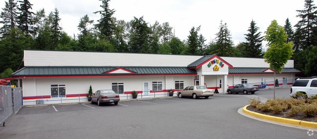
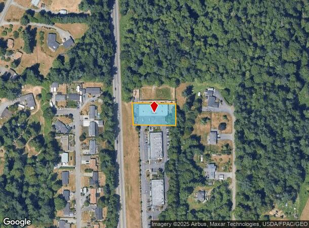
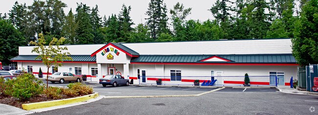
Property Record
9623 32Nd St Se, Lake Stevens, WA 98258
NEARBY LISTINGS FOR SALE OR LEASE
Property Detail
9623 32Nd St Se
Seattle-Tacoma-Bellevue, WA
Highway 9 Business Center Condominium
009452-000-005-00
SECTION 25 TOWNSHIP 29 RANGE 05 QUARTER NE-SE SUBDIVISION HIGHWAY 9 BUSINESS CENTER CONDOMINIUM UNIT E TGW ASSIGNED PARKING (IF ANY) & TGW EQ & UND 23.97% INT IN COM AREAS (INCL TRS 997, 998 & 999) & FACS AS DESC IN DECL REC UND AFN 200212110415 AMEN
Commercialcondominium
Snohomish
X
Washington
53061C1055G
5
2024
0.57 AC
2025
S Snohomish County
052504
Seattle/Puget Sound
9,000 SF
DEMOGRAPHICS near 9623 32Nd St Se
1 Mile
3 Mile
5 Mile
2024 Total Population
8,067
43,312
100,687
2029 Population
8,540
45,548
105,685
Pop Growth 2024-2029
+ 5.86%
+ 5.16%
+ 4.96%
Average Age
37
37
38
2024 Total Households
2,734
14,826
36,798
HH Growth 2024-2029
+ 5.93%
+ 5.25%
+ 5.00%
Median Household Inc
$113,415
$111,971
$99,389
Avg Household Size
2.90
2.90
2.70
2024 Avg HH Vehicles
3.00
2.00
2.00
Median Home Value
$605,273
$610,468
$599,296
Median Year Built
1992
1995
1990
Nearby Places
Map Layers
Map Styles
 Street
 Aerial
- Restaurants
- Banks
- Shops
- Fitness
- Groceries
PUBLIC TRANSPORTATION
COMMUTER RAIL
Everett Station (Sounder South Line - Central Puget Sound Regional Transit Authority Rail (Link Light Rail/Sounder))
DRIVE
WALK
Distance
Everett Station (Sounder South Line - Central Puget Sound Regional Transit Authority Rail (Link Light Rail/Sounder))
12 min
7.1 mi
Freight Ports
Port of Everett
DRIVE
WALK
Distance
Port of Everett
1 min
5.3 mi
Nearby Properties
Address
Land Use
TOTAL SIZE
Lot Size
Zoning
Address
Land Use
TOTAL SIZE
Lot Size
Zoning
226,994 SF
18.28 AC
P/SP
Address
Land Use
TOTAL SIZE
Lot Size
Zoning
113,456 SF
19.25 AC
A-10
Address
Land Use
TOTAL SIZE
Lot Size
Zoning
141,942 SF
24.69 AC
P/SP
Address
Land Use
TOTAL SIZE
Lot Size
Zoning
83,334 SF
9.56 AC
R-5
Address
Land Use
TOTAL SIZE
Lot Size
Zoning
167,803 SF
13.82 AC
BP
Address
Land Use
TOTAL SIZE
Lot Size
Zoning
125,434 SF
11.43 AC
CD
Address
Land Use
TOTAL SIZE
Lot Size
Zoning
76,644 SF
8.47 AC
CD
Address
Land Use
TOTAL SIZE
Lot Size
Zoning
76,968 SF
3.22 AC
P/SP
Address
Land Use
TOTAL SIZE
Lot Size
Zoning
75,010 SF
4.53 AC
BP
Address
Land Use
TOTAL SIZE
Lot Size
Zoning
107,112 SF
10.21 AC
BP
Address
Land Use
TOTAL SIZE
Lot Size
Zoning
60,586 SF
11.11 AC
CD
Address
Land Use
TOTAL SIZE
Lot Size
Zoning
50,532 SF
5.29 AC
BP
Address
Land Use
TOTAL SIZE
Lot Size
Zoning
96,796 SF
8.86 AC
BP
Address
Land Use
TOTAL SIZE
Lot Size
Zoning
106,900 SF
1.97 AC
LB
Address
Land Use
TOTAL SIZE
Lot Size
Zoning
71,581 SF
5.72 AC
COM
Address
Land Use
TOTAL SIZE
Lot Size
Zoning
62,728 SF
2.01 AC
CD
Address
Land Use
TOTAL SIZE
Lot Size
Zoning
58,495 SF
3.21 AC
CD
Address
Land Use
TOTAL SIZE
Lot Size
Zoning
11.39 AC
P/SP
Address
Land Use
TOTAL SIZE
Lot Size
Zoning
12.14 AC
P/SP
Address
Land Use
TOTAL SIZE
Lot Size
Zoning
76,940 SF
3.12 AC
BP
Address
Land Use
TOTAL SIZE
Lot Size
Zoning
29,110 SF
9.04 AC
SFR
Address
Land Use
TOTAL SIZE
Lot Size
Zoning
60,636 SF
2.93 AC
BP
Address
Land Use
TOTAL SIZE
Lot Size
Zoning
9,502 SF
1.65 AC
CD
Address
Land Use
TOTAL SIZE
Lot Size
Zoning
63,400 SF
13 AC
BP
Address
Land Use
TOTAL SIZE
Lot Size
Zoning
183,412 SF
8.13 AC
MUN
Address
Land Use
TOTAL SIZE
Lot Size
Zoning
25,080 SF
5.08 AC
R6
Address
Land Use
TOTAL SIZE
Lot Size
Zoning
46,963 SF
3.91 AC
CD
Address
Land Use
TOTAL SIZE
Lot Size
Zoning
18.34 AC
P/SP
The World's #1 Commercial Real Estate Marketplace
Connect with us
© 2025 CoStar Group
The information above has been obtained from sources believed reliable. While we do not doubt its accuracy we have not verified it and make no guarantee, warranty or representation about it. It is your responsibility to independently confirm its accuracy and completeness. Any projections, opinions, assumptions, or estimates used are for example only and do not represent the current or future performance of the property. The value of this transaction to you depends on tax and other factors which should be evaluated by your tax, financial, and legal advisors. You and your advisors should conduct a careful, independent investigation of the property to determine to your satisfaction the suitability of the property for your needs.