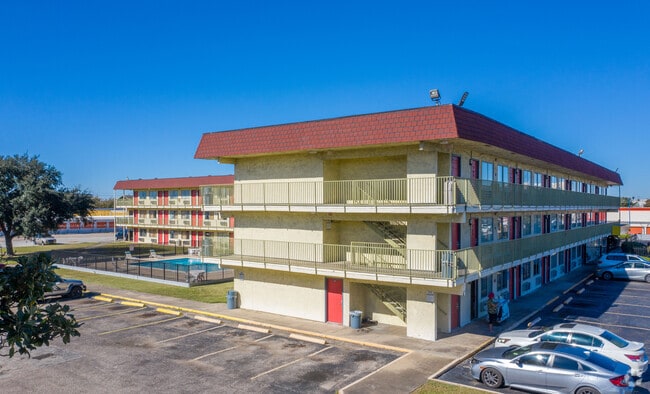
Property Record
9638 Plainfield St, Houston, TX 77036


NEARBY LISTINGS FOR SALE OR LEASE
Property Detail
9638 Plainfield St
Houston-The Woodlands-Sugar Land, TX
Richmond Road Country Club Villas
0770370010019
LTS 6 7 & 8 & TR 5A BLK 1 & TR 8B RICHMOND ROAD COUNTRY CLUB VILLAS
Hotel
Harris
X
Texas
48201C0845M
6
2024
2.99 AC
2025
Houston Southwest Freeway
433602
Houston
33,449 SF
DEMOGRAPHICS near 9638 Plainfield St
1 Mile
3 Mile
5 Mile
2024 Total Population
29,594
212,661
523,081
2029 Population
30,438
218,595
544,113
Pop Growth 2024-2029
+ 2.85%
+ 2.79%
+ 4.02%
Average Age
32
36
36
2024 Total Households
10,676
74,631
191,638
HH Growth 2024-2029
+ 2.76%
+ 2.87%
+ 4.03%
Median Household Inc
$32,212
$39,430
$43,362
Avg Household Size
2.70
2.80
2.60
2024 Avg HH Vehicles
1.00
1.00
2.00
Median Home Value
$153,369
$183,487
$207,420
Median Year Built
1979
1978
1979
Nearby Places
Map Layers
Map Styles
 Street
 Aerial
- Restaurants
- Banks
- Shops
- Fitness
- Groceries
PUBLIC TRANSPORTATION
AIRPORT
William P Hobby
DRIVE
WALK
Distance
William P Hobby
36 min
22.7 mi
George Bush Intcntl/Houston
DRIVE
WALK
Distance
George Bush Intcntl/Houston
43 min
32.7 mi
Freight Ports
Port of Houston
DRIVE
WALK
Distance
Port of Houston
35 min
23.4 mi
SALE & LEASE HISTORY
LISTING DATE
SALE/LEASE

Sep 10, 2019
For Sale
Apr 21, 2020
For Sale
Nearby Properties
Address
Land Use
TOTAL SIZE
Lot Size
Zoning
Address
Land Use
TOTAL SIZE
Lot Size
Zoning
7.46 AC
Address
Land Use
TOTAL SIZE
Lot Size
Zoning
12.98 AC
Address
Land Use
TOTAL SIZE
Lot Size
Zoning
11.58 AC
Address
Land Use
TOTAL SIZE
Lot Size
Zoning
12.08 AC
Address
Land Use
TOTAL SIZE
Lot Size
Zoning
627,632 SF
24.12 AC
Address
Land Use
TOTAL SIZE
Lot Size
Zoning
816,006 SF
40.26 AC
Address
Land Use
TOTAL SIZE
Lot Size
Zoning
188,178 SF
18.49 AC
Address
Land Use
TOTAL SIZE
Lot Size
Zoning
771,720 SF
19.28 AC
Address
Land Use
TOTAL SIZE
Lot Size
Zoning
539,308 SF
21 AC
Address
Land Use
TOTAL SIZE
Lot Size
Zoning
76,385 SF
17.48 AC
Address
Land Use
TOTAL SIZE
Lot Size
Zoning
12.22 AC
Address
Land Use
TOTAL SIZE
Lot Size
Zoning
183,015 SF
9.91 AC
Address
Land Use
TOTAL SIZE
Lot Size
Zoning
456,076 SF
19.09 AC
Address
Land Use
TOTAL SIZE
Lot Size
Zoning
322,894 SF
17.51 AC
Address
Land Use
TOTAL SIZE
Lot Size
Zoning
304,006 SF
11.14 AC
Address
Land Use
TOTAL SIZE
Lot Size
Zoning
623,343 SF
22.89 AC
Address
Land Use
TOTAL SIZE
Lot Size
Zoning
725,466 SF
9.69 AC
Address
Land Use
TOTAL SIZE
Lot Size
Zoning
574,191 SF
8.32 AC
Address
Land Use
TOTAL SIZE
Lot Size
Zoning
355,887 SF
13.89 AC
Address
Land Use
TOTAL SIZE
Lot Size
Zoning
269,067 SF
17.98 AC
Address
Land Use
TOTAL SIZE
Lot Size
Zoning
52,502 SF
13.60 AC
XYS
Address
Land Use
TOTAL SIZE
Lot Size
Zoning
434,744 SF
16.74 AC
Address
Land Use
TOTAL SIZE
Lot Size
Zoning
364,674 SF
13.79 AC
Address
Land Use
TOTAL SIZE
Lot Size
Zoning
307,488 SF
11 AC
Address
Land Use
TOTAL SIZE
Lot Size
Zoning
256,810 SF
22.65 AC
Address
Land Use
TOTAL SIZE
Lot Size
Zoning
349,982 SF
18.44 AC
Address
Land Use
TOTAL SIZE
Lot Size
Zoning
240,853 SF
19.07 AC
Address
Land Use
TOTAL SIZE
Lot Size
Zoning
280,309 SF
9.98 AC
Address
Land Use
TOTAL SIZE
Lot Size
Zoning
282,636 SF
4.18 AC
Address
Land Use
TOTAL SIZE
Lot Size
Zoning
185,541 SF
10.51 AC
The World's #1 Commercial Real Estate Marketplace
Connect with us
© 2026 CoStar Group
The information above has been obtained from sources believed reliable. While we do not doubt its accuracy we have not verified it and make no guarantee, warranty or representation about it. It is your responsibility to independently confirm its accuracy and completeness. Any projections, opinions, assumptions, or estimates used are for example only and do not represent the current or future performance of the property. The value of this transaction to you depends on tax and other factors which should be evaluated by your tax, financial, and legal advisors. You and your advisors should conduct a careful, independent investigation of the property to determine to your satisfaction the suitability of the property for your needs.