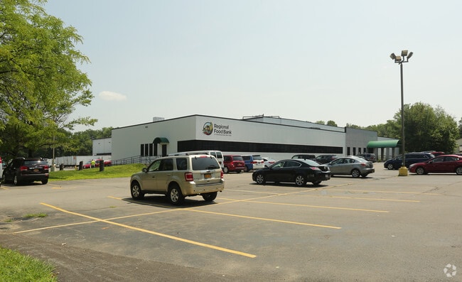
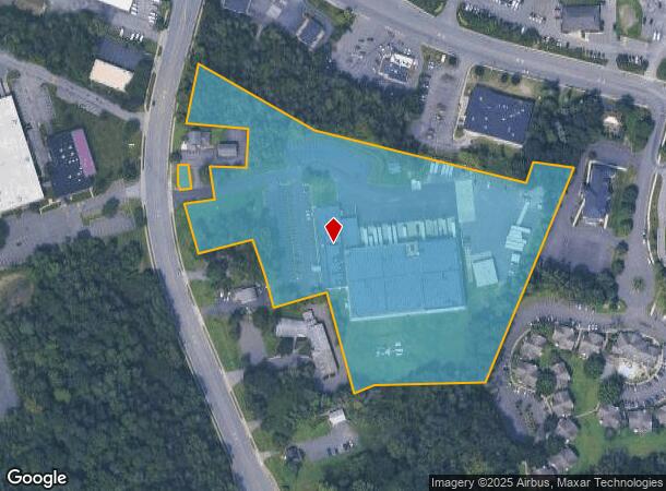
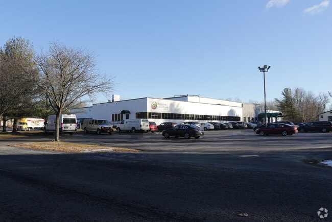
Property Record
965 Albany Shaker Rd, Latham, NY 12110
NEARBY LISTINGS FOR SALE OR LEASE
Property Detail
965 Albany Shaker Rd
012689-018-000-0002-065-000-0000
N-1003 E-1072 TROY SCHDY C-14-46.1
Warehouse
Albany
X
New York
36001C0064D
65.000
2025
10.27 AC
2024
E Outer Albany County
013703
Albany/Schenectady/Troy
57,453 SF
Albany-Schenectady-Troy, NY
DEMOGRAPHICS near 965 Albany Shaker Rd
1 Mile
3 Mile
5 Mile
2024 Total Population
1,555
28,702
105,099
2029 Population
1,576
28,912
106,024
Pop Growth 2024-2029
+ 1.35%
+ 0.73%
+ 0.88%
Average Age
44
42
43
2024 Total Households
505
11,221
42,774
HH Growth 2024-2029
+ 1.39%
+ 0.69%
+ 0.84%
Median Household Inc
$113,619
$97,182
$94,529
Avg Household Size
2.60
2.50
2.30
2024 Avg HH Vehicles
2.00
2.00
2.00
Median Home Value
$323,256
$292,579
$276,724
Median Year Built
1973
1976
1974
Nearby Places
Map Layers
Map Styles
 Street
 Aerial
- Restaurants
- Banks
- Shops
- Fitness
- Groceries
PUBLIC TRANSPORTATION
COMMUTER RAIL
Schenectady (Adirondack - VIA Rail, Empire Service - VIA Rail, Ethan Allen Express - VIA Rail, Lake Shore Limited - VIA Rail, Maple Leaf - VIA Rail, Toronto - New York - VIA Rail)
DRIVE
WALK
Distance
Schenectady (Adirondack - VIA Rail, Empire Service - VIA Rail, Ethan Allen Express - VIA Rail, Lake Shore Limited - VIA Rail, Maple Leaf - VIA Rail, Toronto - New York - VIA Rail)
17 min
7.8 mi
AIRPORT
Albany International
DRIVE
WALK
Distance
Albany International
5 min
2.3 mi
Freight Ports
Albany, NY Port
DRIVE
WALK
Distance
Albany, NY Port
25 min
13.1 mi
Nearby Properties
Address
Land Use
TOTAL SIZE
Lot Size
Zoning
Address
Land Use
TOTAL SIZE
Lot Size
Zoning
821,670 SF
803.50 AC
17
Address
Land Use
TOTAL SIZE
Lot Size
Zoning
154,580 SF
89.34 AC
16
Address
Land Use
TOTAL SIZE
Lot Size
Zoning
90,316 SF
57.10 AC
04 - FARM
Address
Land Use
TOTAL SIZE
Lot Size
Zoning
226,171 SF
26.39 AC
12
Address
Land Use
TOTAL SIZE
Lot Size
Zoning
242,630 SF
18.50 AC
16
Address
Land Use
TOTAL SIZE
Lot Size
Zoning
84,242 SF
43.60 AC
12
Address
Land Use
TOTAL SIZE
Lot Size
Zoning
25,786 SF
8 AC
17
Address
Land Use
TOTAL SIZE
Lot Size
Zoning
167,222 SF
15.65 AC
14
Address
Land Use
TOTAL SIZE
Lot Size
Zoning
162,500 SF
19.90 AC
17
Address
Land Use
TOTAL SIZE
Lot Size
Zoning
141,570 SF
4.43 AC
12
Address
Land Use
TOTAL SIZE
Lot Size
Zoning
264,473 SF
26.40 AC
25
Address
Land Use
TOTAL SIZE
Lot Size
Zoning
83,120 SF
126.75 AC
25
Address
Land Use
TOTAL SIZE
Lot Size
Zoning
151,287 SF
11.20 AC
12
Address
Land Use
TOTAL SIZE
Lot Size
Zoning
73,736 SF
7.58 AC
14
Address
Land Use
TOTAL SIZE
Lot Size
Zoning
214,716 SF
28.40 AC
19
Address
Land Use
TOTAL SIZE
Lot Size
Zoning
9,774 SF
49.20 AC
43
Address
Land Use
TOTAL SIZE
Lot Size
Zoning
53,852 SF
43.35 AC
25
Address
Land Use
TOTAL SIZE
Lot Size
Zoning
25,112 SF
13.16 AC
04 - FARM
Address
Land Use
TOTAL SIZE
Lot Size
Zoning
Address
Land Use
TOTAL SIZE
Lot Size
Zoning
108,656 SF
6.44 AC
12
Address
Land Use
TOTAL SIZE
Lot Size
Zoning
10,088 SF
30.04 AC
08 - GOVER
Address
Land Use
TOTAL SIZE
Lot Size
Zoning
186,095 SF
14.94 AC
12
Address
Land Use
TOTAL SIZE
Lot Size
Zoning
269,318 SF
7.60 AC
17
Address
Land Use
TOTAL SIZE
Lot Size
Zoning
106,723 SF
4.73 AC
12
Address
Land Use
TOTAL SIZE
Lot Size
Zoning
144,030 SF
19.70 AC
19
Address
Land Use
TOTAL SIZE
Lot Size
Zoning
6,904 SF
9.92 AC
16
Address
Land Use
TOTAL SIZE
Lot Size
Zoning
16,545 SF
21.40 AC
04 - FARM
Address
Land Use
TOTAL SIZE
Lot Size
Zoning
133,112 SF
17.56 AC
16
Address
Land Use
TOTAL SIZE
Lot Size
Zoning
69,026 SF
3.50 AC
12
Address
Land Use
TOTAL SIZE
Lot Size
Zoning
149,241 SF
26.80 AC
17
The World's #1 Commercial Real Estate Marketplace
Connect with us
© 2025 CoStar Group
The information above has been obtained from sources believed reliable. While we do not doubt its accuracy we have not verified it and make no guarantee, warranty or representation about it. It is your responsibility to independently confirm its accuracy and completeness. Any projections, opinions, assumptions, or estimates used are for example only and do not represent the current or future performance of the property. The value of this transaction to you depends on tax and other factors which should be evaluated by your tax, financial, and legal advisors. You and your advisors should conduct a careful, independent investigation of the property to determine to your satisfaction the suitability of the property for your needs.