Property Record
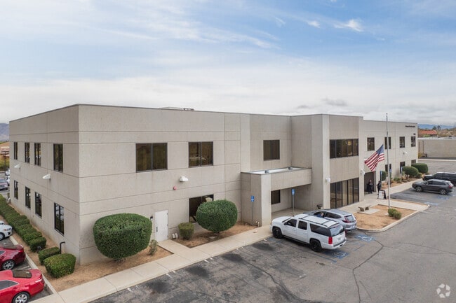
9655 9Th Ave, Hesperia, CA 92345


Property Detail
9655 9Th Ave
0413-021-02
PARCEL MAP 14668 PARCEL 1 BOOK 176 PAGE 26 PARCEL MAP 14668 PARCEL NO 1 AND PTN YUCCA ST VAC ADJ ON THE S ***** 11-9-94 #94-453109 VAC *****
Officebuilding
San Bernardino
B and X Area of moderate flood hazard, usually the area between the limits of the 100-year and 500-year floods.
California
2025
2.82 AC
2025
Mojave River Valley
010015
Inland Empire (California)
33,600 SF
Riverside-San Bernardino-Ontario, CA
NEARBY LISTINGS FOR SALE OR LEASE
DEMOGRAPHICS near 9655 9Th Ave
1 mile
3 mile
5 mile
2025 Total Population
8,674
63,155
151,649
2030 Population
8,802
64,169
154,104
Pop Growth 2025-2030
+ 1.48%
+ 1.61%
+ 1.62%
Average Age
36
36
37
2025 Total Households
2,552
18,316
45,634
HH Growth 2025-2030
+ 1.45%
+ 1.57%
+ 1.56%
Median Household Inc
$60,753
$71,187
$74,675
Avg Household Size
3.40
3.40
3.30
2025 Avg HH Vehicles
2.00
2.00
2.00
Median Home Value
$372,434
$393,134
$398,909
Median Year Built
1980
1986
1988
Nearby Places
Map Layers
Map Styles
 Street
 Aerial
Layers
 Traffic
 Biking
Places
Listings with unknown addresses are not visible on the map
- Restaurants
- Banks
- Shops
- Fitness
- Groceries
Nearby Properties
Address
Land Use
TOTAL SIZE
Lot Size
Zoning
Address
Land Use
TOTAL SIZE
Lot Size
Zoning
213,482 SF
19.98 AC
Address
Land Use
TOTAL SIZE
Lot Size
Zoning
158,417 SF
9.66 AC
Address
Land Use
TOTAL SIZE
Lot Size
Zoning
171,830 SF
9.01 AC
Address
Land Use
TOTAL SIZE
Lot Size
Zoning
194,712 SF
20.24 AC
Address
Land Use
TOTAL SIZE
Lot Size
Zoning
174,855 SF
15.46 AC
Address
Land Use
TOTAL SIZE
Lot Size
Zoning
142,661 SF
14.21 AC
Address
Land Use
TOTAL SIZE
Lot Size
Zoning
79,477 SF
4.70 AC
Address
Land Use
TOTAL SIZE
Lot Size
Zoning
80,080 SF
4.88 AC
Address
Land Use
TOTAL SIZE
Lot Size
Zoning
119,525 SF
6.42 AC
Address
Land Use
TOTAL SIZE
Lot Size
Zoning
125,694 SF
10.51 AC
Address
Land Use
TOTAL SIZE
Lot Size
Zoning
65,440 SF
12.70 AC
Address
Land Use
TOTAL SIZE
Lot Size
Zoning
79,477 SF
4.33 AC
Address
Land Use
TOTAL SIZE
Lot Size
Zoning
127,502 SF
9.32 AC
Address
Land Use
TOTAL SIZE
Lot Size
Zoning
41,249 SF
4.84 AC
Address
Land Use
TOTAL SIZE
Lot Size
Zoning
98,624 SF
8.23 AC
Address
Land Use
TOTAL SIZE
Lot Size
Zoning
59,841 SF
3.99 AC
Address
Land Use
TOTAL SIZE
Lot Size
Zoning
14,228 SF
1.53 AC
Address
Land Use
TOTAL SIZE
Lot Size
Zoning
102,120 SF
11 AC
Address
Land Use
TOTAL SIZE
Lot Size
Zoning
70,023 SF
4.52 AC
Address
Land Use
TOTAL SIZE
Lot Size
Zoning
69,000 SF
3.17 AC
Address
Land Use
TOTAL SIZE
Lot Size
Zoning
152,482 SF
14.72 AC
R3
Address
Land Use
TOTAL SIZE
Lot Size
Zoning
86,852 SF
4.86 AC
Address
Land Use
TOTAL SIZE
Lot Size
Zoning
29,988 SF
3.21 AC
Address
Land Use
TOTAL SIZE
Lot Size
Zoning
41,640 SF
4.06 AC
Address
Land Use
TOTAL SIZE
Lot Size
Zoning
36,231 SF
3.71 AC
Address
Land Use
TOTAL SIZE
Lot Size
Zoning
82,584 SF
4.91 AC
Address
Land Use
TOTAL SIZE
Lot Size
Zoning
78,412 SF
4 AC
Address
Land Use
TOTAL SIZE
Lot Size
Zoning
37,601 SF
11.80 AC
Address
Land Use
TOTAL SIZE
Lot Size
Zoning
54,134 SF
5.10 AC
Address
Land Use
TOTAL SIZE
Lot Size
Zoning
35,290 SF
6.20 AC
The World's #1 Commercial Real Estate Marketplace
Connect with us
© 2026 CoStar Group
The information above has been obtained from sources believed reliable. While we do not doubt its accuracy we have not verified it and make no guarantee, warranty or representation about it. It is your responsibility to independently confirm its accuracy and completeness. Any projections, opinions, assumptions, or estimates used are for example only and do not represent the current or future performance of the property. The value of this transaction to you depends on tax and other factors which should be evaluated by your tax, financial, and legal advisors. You and your advisors should conduct a careful, independent investigation of the property to determine to your satisfaction the suitability of the property for your needs.