Property Record
9655 Sw Mckenzie St, Portland, OR 97223
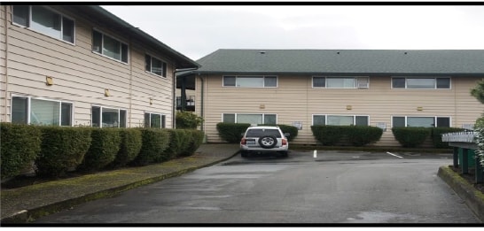

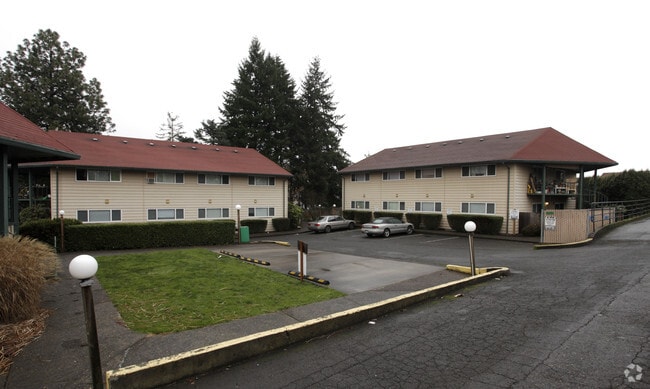

Property Detail
9655 Sw Mckenzie St
R0461887
ACRES 1.83
Apartment
WASHINGTON
R-25
Oregon
B and X Area of moderate flood hazard, usually the area between the limits of the 100-year and 500-year floods.
1.83 AC
2024
Downtown Tigard
2026
Portland
030801
Portland-Vancouver-Hillsboro, OR-WA
30,498 SF
NEARBY LISTINGS FOR SALE OR LEASE
DEMOGRAPHICS near 9655 Sw Mckenzie St
1 mile
3 mile
5 mile
2025 Total Population
14,855
135,935
294,254
2030 Population
15,095
137,053
295,963
Pop Growth 2025-2030
+ 1.62%
+ 0.82%
+ 0.58%
Average Age
40
42
42
2025 Total Households
5,930
56,230
118,524
HH Growth 2025-2030
+ 1.79%
+ 0.92%
+ 0.60%
Median Household Inc
$87,677
$101,421
$107,153
Avg Household Size
2.40
2.40
2.40
2025 Avg HH Vehicles
2.00
2.00
2.00
Median Home Value
$608,055
$655,481
$691,921
Median Year Built
1978
1985
1982
Nearby Places
Map Layers
Map Styles
 Street
 Aerial
Transit
 Traffic
 Biking
Places
Listings with unknown addresses are not visible on the map
- Restaurants
- Banks
- Shops
- Fitness
- Groceries
SALE & LEASE HISTORY
LISTING DATE
SALE/LEASE

Mar 09, 2017
For Sale
Nearby Properties
Address
Land Use
TOTAL SIZE
Lot Size
Zoning
Address
Land Use
TOTAL SIZE
Lot Size
Zoning
49.34 AC
I-P
Address
Land Use
TOTAL SIZE
Lot Size
Zoning
828,566 SF
54.77 AC
CI2
Address
Land Use
TOTAL SIZE
Lot Size
Zoning
511,394 SF
18.68 AC
MUC
Address
Land Use
TOTAL SIZE
Lot Size
Zoning
888,084 SF
31.12 AC
MUC
Address
Land Use
TOTAL SIZE
Lot Size
Zoning
1 SF
16 AC
R-5
Address
Land Use
TOTAL SIZE
Lot Size
Zoning
Address
Land Use
TOTAL SIZE
Lot Size
Zoning
43.20 AC
R-4.5
Address
Land Use
TOTAL SIZE
Lot Size
Zoning
14.77 AC
MUE
Address
Land Use
TOTAL SIZE
Lot Size
Zoning
213,947 SF
14.45 AC
TC-MU
Address
Land Use
TOTAL SIZE
Lot Size
Zoning
27.23 AC
MP
Address
Land Use
TOTAL SIZE
Lot Size
Zoning
88,000 SF
15.49 AC
R-4.5
Address
Land Use
TOTAL SIZE
Lot Size
Zoning
20.82 AC
R-5
Address
Land Use
TOTAL SIZE
Lot Size
Zoning
256,070 SF
32.39 AC
R7
Address
Land Use
TOTAL SIZE
Lot Size
Zoning
6 AC
MC
Address
Land Use
TOTAL SIZE
Lot Size
Zoning
43,537 SF
3.59 AC
MUC
Address
Land Use
TOTAL SIZE
Lot Size
Zoning
183,133 SF
8.17 AC
R-25
Address
Land Use
TOTAL SIZE
Lot Size
Zoning
Address
Land Use
TOTAL SIZE
Lot Size
Zoning
11,736 SF
2.85 AC
MUE-1
Address
Land Use
TOTAL SIZE
Lot Size
Zoning
5,724 SF
13.95 AC
NC/R-0
Address
Land Use
TOTAL SIZE
Lot Size
Zoning
158,824 SF
20.71 AC
CC
Address
Land Use
TOTAL SIZE
Lot Size
Zoning
423,095 SF
21.51 AC
R1
Address
Land Use
TOTAL SIZE
Lot Size
Zoning
190,012 SF
4.59 AC
IP
Address
Land Use
TOTAL SIZE
Lot Size
Zoning
88,000 SF
12.62 AC
R-4.5
Address
Land Use
TOTAL SIZE
Lot Size
Zoning
128,176 SF
25.06 AC
R7
Address
Land Use
TOTAL SIZE
Lot Size
Zoning
20.98 AC
R5
Address
Land Use
TOTAL SIZE
Lot Size
Zoning
4,046 SF
4.08 AC
MUE-1
Address
Land Use
TOTAL SIZE
Lot Size
Zoning
294,220 SF
15.10 AC
RH
Address
Land Use
TOTAL SIZE
Lot Size
Zoning
301,940 SF
15.04 AC
MU-CBD
The World's #1 Commercial Real Estate Marketplace
Connect with us
© 2026 CoStar Group
The information above has been obtained from sources believed reliable. While we do not doubt its accuracy we have not verified it and make no guarantee, warranty or representation about it. It is your responsibility to independently confirm its accuracy and completeness. Any projections, opinions, assumptions, or estimates used are for example only and do not represent the current or future performance of the property. The value of this transaction to you depends on tax and other factors which should be evaluated by your tax, financial, and legal advisors. You and your advisors should conduct a careful, independent investigation of the property to determine to your satisfaction the suitability of the property for your needs.