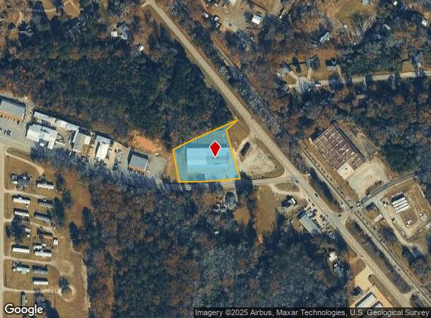
Property Record
9667 Mullin Rd, Smiths Station, AL 36877


NEARBY LISTINGS FOR SALE OR LEASE
Property Detail
9667 Mullin Rd
Auburn-Opelika, AL
Roberts Property Division
14-09-31-0-002-087.000
PARCEL E BOUNDARY SURVEY ROBERTS PROPERTY DIVISION PROPERTY DIVISION OF 7.7 ACRES PLAT 37-67 SEC 31 T18N R30E
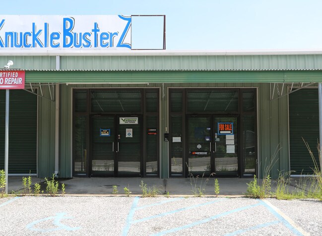
Vacantlandnec
Lee
X
Alabama
01113C0039D
e
2025
1.32 AC
2025
Lee County
042006
Columbus GA
7,220 SF
DEMOGRAPHICS near 9667 Mullin Rd
1 Mile
3 Mile
5 Mile
2024 Total Population
3,507
31,146
72,345
2029 Population
3,838
32,843
74,724
Pop Growth 2024-2029
+ 9.44%
+ 5.45%
+ 3.29%
Average Age
40
39
39
2024 Total Households
1,379
12,236
29,174
HH Growth 2024-2029
+ 9.43%
+ 5.07%
+ 3.01%
Median Household Inc
$52,995
$58,347
$50,099
Avg Household Size
2.50
2.50
2.40
2024 Avg HH Vehicles
2.00
2.00
2.00
Median Home Value
$173,765
$172,670
$159,899
Median Year Built
1996
1994
1989
Nearby Places
Map Layers
Map Styles
 Street
 Aerial
- Restaurants
- Banks
- Shops
- Fitness
- Groceries
PUBLIC TRANSPORTATION
AIRPORT
Columbus
DRIVE
WALK
Distance
Columbus
17 min
9.8 mi
Nearby Properties
Address
Land Use
TOTAL SIZE
Lot Size
Zoning
Address
Land Use
TOTAL SIZE
Lot Size
Zoning
17,000 SF
6 AC
O
Address
Land Use
TOTAL SIZE
Lot Size
Zoning
24.20 AC
Address
Land Use
TOTAL SIZE
Lot Size
Zoning
23,488 SF
26 AC
Address
Land Use
TOTAL SIZE
Lot Size
Zoning
43,056 SF
4 AC
O
Address
Land Use
TOTAL SIZE
Lot Size
Zoning
9,506 SF
15 AC
O
Address
Land Use
TOTAL SIZE
Lot Size
Zoning
10,160 SF
16.26 AC
O
Address
Land Use
TOTAL SIZE
Lot Size
Zoning
57,826 SF
7 AC
O
Address
Land Use
TOTAL SIZE
Lot Size
Zoning
3,420 SF
16 AC
O
Address
Land Use
TOTAL SIZE
Lot Size
Zoning
11,124 SF
5 AC
Address
Land Use
TOTAL SIZE
Lot Size
Zoning
58,094 SF
8.27 AC
Address
Land Use
TOTAL SIZE
Lot Size
Zoning
104,950 SF
6 AC
C
Address
Land Use
TOTAL SIZE
Lot Size
Zoning
30,120 SF
7 AC
Address
Land Use
TOTAL SIZE
Lot Size
Zoning
2,816 SF
6 AC
O
Address
Land Use
TOTAL SIZE
Lot Size
Zoning
9,000 SF
10 AC
O
Address
Land Use
TOTAL SIZE
Lot Size
Zoning
81,850 SF
7 AC
O
Address
Land Use
TOTAL SIZE
Lot Size
Zoning
73,270 SF
4.41 AC
O
Address
Land Use
TOTAL SIZE
Lot Size
Zoning
41,937 SF
14 AC
Address
Land Use
TOTAL SIZE
Lot Size
Zoning
1,800 SF
13 AC
O
Address
Land Use
TOTAL SIZE
Lot Size
Zoning
539 SF
10 AC
O
Address
Land Use
TOTAL SIZE
Lot Size
Zoning
36,840 SF
5 AC
C
Address
Land Use
TOTAL SIZE
Lot Size
Zoning
75,778 SF
9 AC
O
Address
Land Use
TOTAL SIZE
Lot Size
Zoning
99,275 SF
4 AC
O
Address
Land Use
TOTAL SIZE
Lot Size
Zoning
11,768 SF
16.80 AC
Address
Land Use
TOTAL SIZE
Lot Size
Zoning
3,150 SF
2.39 AC
O
Address
Land Use
TOTAL SIZE
Lot Size
Zoning
1,620 SF
12 AC
O
Address
Land Use
TOTAL SIZE
Lot Size
Zoning
20,400 SF
2 AC
Address
Land Use
TOTAL SIZE
Lot Size
Zoning
Address
Land Use
TOTAL SIZE
Lot Size
Zoning
10,672 SF
5.55 AC
The World's #1 Commercial Real Estate Marketplace
Connect with us
© 2025 CoStar Group
The information above has been obtained from sources believed reliable. While we do not doubt its accuracy we have not verified it and make no guarantee, warranty or representation about it. It is your responsibility to independently confirm its accuracy and completeness. Any projections, opinions, assumptions, or estimates used are for example only and do not represent the current or future performance of the property. The value of this transaction to you depends on tax and other factors which should be evaluated by your tax, financial, and legal advisors. You and your advisors should conduct a careful, independent investigation of the property to determine to your satisfaction the suitability of the property for your needs.