Property Record
9669 Highland Rd, White Lake, MI 48386
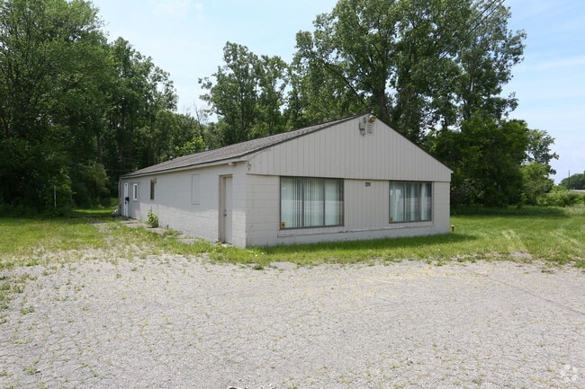
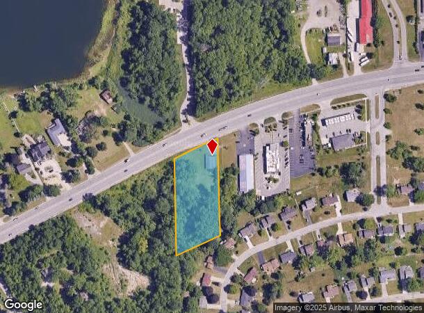
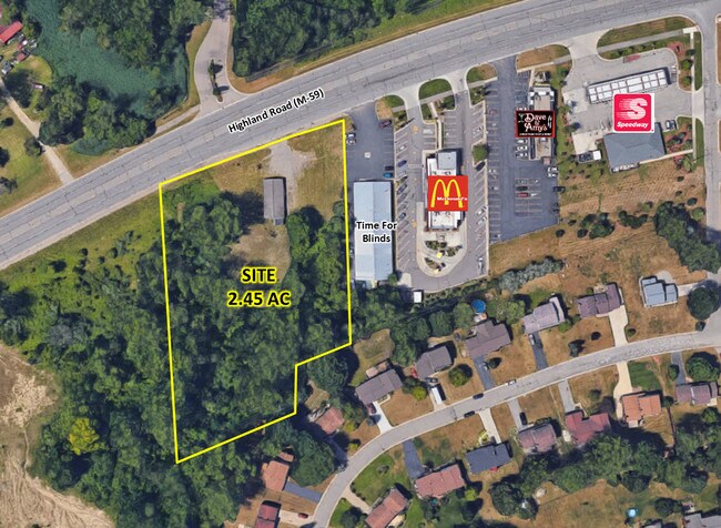
This Property Is For Sale
NEARBY LISTINGS FOR SALE OR LEASE
Property Detail
9669 Highland Rd
12-23-128-001
T3N, R8E, SEC 23 PART OF NW 1/4 BEG AT INTER OF W 1/8 LINE & SLY LINE OF M-59 HWY, TH NELY ALG SD LINE 200 FT, TH S 400 FT,
Storebuilding
Oakland
X
Michigan
26125C0338F
1.66 AC
2024
St Clair & Lapeer Counties
2025
Detroit
130400
Detroit-Warren-Dearborn, MI
1,800 SF
DEMOGRAPHICS near 9669 Highland Rd
1 Mile
3 Mile
5 Mile
2024 Total Population
3,916
27,470
88,186
2029 Population
3,875
27,341
87,373
Pop Growth 2024-2029
(1.05%)
(0.47%)
(0.92%)
Average Age
46
43
42
2024 Total Households
1,666
11,115
35,584
HH Growth 2024-2029
(1.08%)
(0.49%)
(0.94%)
Median Household Inc
$84,746
$88,958
$87,082
Avg Household Size
2.30
2.40
2.40
2024 Avg HH Vehicles
2.00
2.00
2.00
Median Home Value
$267,015
$283,178
$274,105
Median Year Built
1979
1980
1978
Nearby Places
Map Layers
Map Styles
 Street
 Aerial
- Restaurants
- Banks
- Shops
- Fitness
- Groceries
PUBLIC TRANSPORTATION
AIRPORT
Bishop International
DRIVE
WALK
Distance
Bishop International
53 min
34.1 mi
Detroit Metro Wayne County
DRIVE
WALK
Distance
Detroit Metro Wayne County
58 min
41.1 mi
Nearby Properties
Address
Land Use
TOTAL SIZE
Lot Size
Zoning
Address
Land Use
TOTAL SIZE
Lot Size
Zoning
190,753 SF
16.54 AC
AI
Address
Land Use
TOTAL SIZE
Lot Size
Zoning
16,640 SF
13.07 AC
ME
Address
Land Use
TOTAL SIZE
Lot Size
Zoning
86,192 SF
19.27 AC
Address
Land Use
TOTAL SIZE
Lot Size
Zoning
150,669 SF
16.57 AC
AI
Address
Land Use
TOTAL SIZE
Lot Size
Zoning
4,011 SF
53.71 AC
MM
Address
Land Use
TOTAL SIZE
Lot Size
Zoning
151,611 SF
12.16 AC
AI
Address
Land Use
TOTAL SIZE
Lot Size
Zoning
3,908 SF
54.90 AC
MM
Address
Land Use
TOTAL SIZE
Lot Size
Zoning
93,541 SF
21.75 AC
SV
Address
Land Use
TOTAL SIZE
Lot Size
Zoning
207,282 SF
55.01 AC
BI
Address
Land Use
TOTAL SIZE
Lot Size
Zoning
119,755 SF
14.03 AC
Address
Land Use
TOTAL SIZE
Lot Size
Zoning
105,874 SF
13.07 AC
BI
Address
Land Use
TOTAL SIZE
Lot Size
Zoning
156,808 SF
13.11 AC
PB
Address
Land Use
TOTAL SIZE
Lot Size
Zoning
92,821 SF
12.19 AC
BI
Address
Land Use
TOTAL SIZE
Lot Size
Zoning
104,296 SF
11.10 AC
BI
Address
Land Use
TOTAL SIZE
Lot Size
Zoning
71,627 SF
13 AC
BV
Address
Land Use
TOTAL SIZE
Lot Size
Zoning
135,053 SF
15.10 AC
PB
Address
Land Use
TOTAL SIZE
Lot Size
Zoning
42,467 SF
13.70 AC
Address
Land Use
TOTAL SIZE
Lot Size
Zoning
70,716 SF
8.93 AC
BI
Address
Land Use
TOTAL SIZE
Lot Size
Zoning
113,668 SF
10.73 AC
PB
Address
Land Use
TOTAL SIZE
Lot Size
Zoning
65,345 SF
5.69 AC
GB
Address
Land Use
TOTAL SIZE
Lot Size
Zoning
88,540 SF
9.07 AC
PB
Address
Land Use
TOTAL SIZE
Lot Size
Zoning
44,594 SF
BI
Address
Land Use
TOTAL SIZE
Lot Size
Zoning
103,525 SF
8.33 AC
PB
Address
Land Use
TOTAL SIZE
Lot Size
Zoning
61,640 SF
3.03 AC
BI
Address
Land Use
TOTAL SIZE
Lot Size
Zoning
57,912 SF
BI
Address
Land Use
TOTAL SIZE
Lot Size
Zoning
93,759 SF
5.55 AC
BI
Address
Land Use
TOTAL SIZE
Lot Size
Zoning
22,448 SF
BI
Address
Land Use
TOTAL SIZE
Lot Size
Zoning
23,300 SF
3.99 AC
BI
Address
Land Use
TOTAL SIZE
Lot Size
Zoning
40,884 SF
BI
Address
Land Use
TOTAL SIZE
Lot Size
Zoning
46,755 SF
5.59 AC
BI
The World's #1 Commercial Real Estate Marketplace
Connect with us
© 2026 CoStar Group
The information above has been obtained from sources believed reliable. While we do not doubt its accuracy we have not verified it and make no guarantee, warranty or representation about it. It is your responsibility to independently confirm its accuracy and completeness. Any projections, opinions, assumptions, or estimates used are for example only and do not represent the current or future performance of the property. The value of this transaction to you depends on tax and other factors which should be evaluated by your tax, financial, and legal advisors. You and your advisors should conduct a careful, independent investigation of the property to determine to your satisfaction the suitability of the property for your needs.