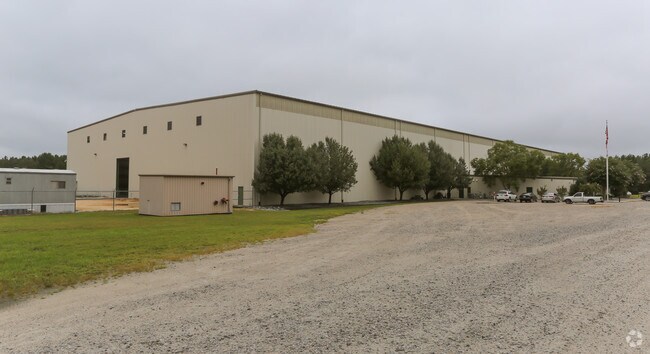
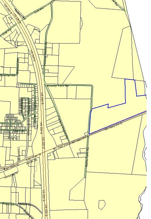
Property Record
967 Nc Highway 211 E, Candor, NC 27229

Save to a Folder
{{folder.Name}}
{{folder.ListingIds.length}} Properties
{{folder.ListingIds.length}} Property
Create a New Folder
Property Detail
967 Nc Highway 211 E
Industrialgeneral
PUBLIC UTILITY TRACT 2/CLARK PUBLIC UTILITY CLRK2
INDUSTRIAL
Montgomery
B and X Area of moderate flood hazard, usually the area between the limits of the 100-year and 500-year floods.
North Carolina
2025
78.67 AC
2025
North Carolina Southeast Area
960501
Other Market Areas
93,500 SF
7586-00-65-7848
NEARBY LISTINGS FOR SALE OR LEASE
DEMOGRAPHICS near 967 Nc Highway 211 E
1 mile
3 mile
5 mile
2025 Total Population
408
2,234
4,507
2030 Population
387
2,189
4,530
Pop Growth 2025-2030
(5.15%)
(2.01%)
+ 0.51%
Average Age
39
38
38
2025 Total Households
158
826
1,663
HH Growth 2025-2030
(5.70%)
(2.42%)
+ 0.36%
Median Household Inc
$48,355
$46,783
$45,157
Avg Household Size
2.60
2.60
2.60
2025 Avg HH Vehicles
2.00
2.00
2.00
Median Home Value
$135,000
$138,622
$136,085
Median Year Built
1980
1978
1978
Nearby Places
Map Layers
Map Styles
 Street
 Aerial
Layers
 Traffic
 Biking
Places
Listings with unknown addresses are not visible on the map
- Restaurants
- Banks
- Shops
- Fitness
- Groceries
Nearby Properties
Address
Land Use
TOTAL SIZE
Lot Size
Zoning
Address
Land Use
TOTAL SIZE
Lot Size
Zoning
16,088 SF
140 AC
INDUSTRIAL
Address
Land Use
TOTAL SIZE
Lot Size
Zoning
19,796 SF
9.64 AC
SKILLED NU
Address
Land Use
TOTAL SIZE
Lot Size
Zoning
1,400 SF
31.16 AC
RA
Address
Land Use
TOTAL SIZE
Lot Size
Zoning
117,500 SF
39.73 AC
Address
Land Use
TOTAL SIZE
Lot Size
Zoning
22,412 SF
13.89 AC
CHURCH
Address
Land Use
TOTAL SIZE
Lot Size
Zoning
34,138 SF
10.84 AC
SCHOOL
Address
Land Use
TOTAL SIZE
Lot Size
Zoning
152,679 SF
10 AC
INDUSTRIAL
Address
Land Use
TOTAL SIZE
Lot Size
Zoning
924 SF
79.04 AC
Address
Land Use
TOTAL SIZE
Lot Size
Zoning
44,320 SF
44.89 AC
RA
Address
Land Use
TOTAL SIZE
Lot Size
Zoning
10,006 SF
6.49 AC
Address
Land Use
TOTAL SIZE
Lot Size
Zoning
479.82 AC
Address
Land Use
TOTAL SIZE
Lot Size
Zoning
77,396 SF
19.70 AC
INDUSTRIAL
Address
Land Use
TOTAL SIZE
Lot Size
Zoning
9,100 SF
1.30 AC
Address
Land Use
TOTAL SIZE
Lot Size
Zoning
301.60 AC
Address
Land Use
TOTAL SIZE
Lot Size
Zoning
6,068 SF
13.86 AC
SCHOOL
Address
Land Use
TOTAL SIZE
Lot Size
Zoning
5,340 SF
66.89 AC
RA
Address
Land Use
TOTAL SIZE
Lot Size
Zoning
31,431 SF
5 AC
INDUSTRIAL
Address
Land Use
TOTAL SIZE
Lot Size
Zoning
4,550 SF
1.82 AC
CONVENIENC
Address
Land Use
TOTAL SIZE
Lot Size
Zoning
125.98 AC
Address
Land Use
TOTAL SIZE
Lot Size
Zoning
9,180 SF
0.81 AC
Address
Land Use
TOTAL SIZE
Lot Size
Zoning
95.12 AC
RESIDENTIA
Address
Land Use
TOTAL SIZE
Lot Size
Zoning
1,870 SF
144.96 AC
Address
Land Use
TOTAL SIZE
Lot Size
Zoning
6,000 SF
2.68 AC
Address
Land Use
TOTAL SIZE
Lot Size
Zoning
4,484 SF
0.51 AC
Address
Land Use
TOTAL SIZE
Lot Size
Zoning
7,600 SF
10.12 AC
Address
Land Use
TOTAL SIZE
Lot Size
Zoning
191.31 AC
RA
Address
Land Use
TOTAL SIZE
Lot Size
Zoning
Address
Land Use
TOTAL SIZE
Lot Size
Zoning
85.19 AC
RESIDENTIA
Address
Land Use
TOTAL SIZE
Lot Size
Zoning
14,800 SF
4.49 AC
The World's #1 Commercial Real Estate Marketplace
Connect with us
© 2026 CoStar Group
The information above has been obtained from sources believed reliable. While we do not doubt its accuracy we have not verified it and make no guarantee, warranty or representation about it. It is your responsibility to independently confirm its accuracy and completeness. Any projections, opinions, assumptions, or estimates used are for example only and do not represent the current or future performance of the property. The value of this transaction to you depends on tax and other factors which should be evaluated by your tax, financial, and legal advisors. You and your advisors should conduct a careful, independent investigation of the property to determine to your satisfaction the suitability of the property for your needs.