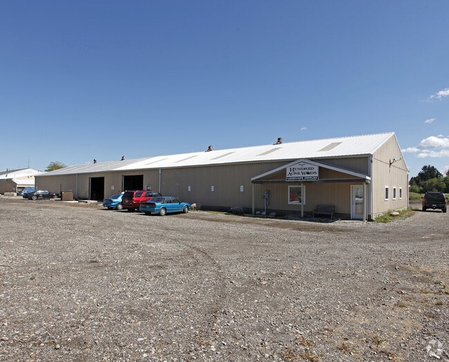
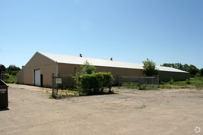
Property Record
967 Norris Rd, Williamston, MI 48895

Property Detail
967 Norris Rd
03-03-33-200-014
COM @ E1/4 COR OF SEC 33 -N89D40'22"W ALNG EW1/4 LN 1296.35FT TO E LN OF NORRIS RD -N28D17'43"E ALNG SD E LN 490.56FT TO POB -N28D17'43"E 270FT -S63D33'37"E 337.77FT -S27D06'44"W 269.69FT -N63D35'30"W 343.35FT TO POB ON NE1/4 OF SEC 33, T4N RIE 2.1A.
Commercialnec
Ingham
B-2
Michigan
B and X Area of moderate flood hazard, usually the area between the limits of the 100-year and 500-year floods.
1.90 AC
2025
Williamston/Weberville
2025
West Michigan
005700
Lansing-East Lansing, MI
10,000 SF
NEARBY LISTINGS FOR SALE OR LEASE
-
-
View all Williamston listings for sale on LoopNet.com
DEMOGRAPHICS near 967 Norris Rd
1 mile
3 mile
5 mile
2025 Total Population
535
8,518
24,381
2030 Population
531
8,581
24,524
Pop Growth 2025-2030
(0.75%)
+ 0.74%
+ 0.59%
Average Age
42
42
42
2025 Total Households
210
3,337
9,450
HH Growth 2025-2030
(0.48%)
+ 0.84%
+ 0.61%
Median Household Inc
$101,786
$98,581
$118,008
Avg Household Size
2.50
2.50
2.50
2025 Avg HH Vehicles
2.00
2.00
2.00
Median Home Value
$267,646
$296,452
$324,850
Median Year Built
1976
1982
1981
Nearby Places
Map Layers
Map Styles
 Street
 Aerial
Layers
 Traffic
 Biking
Places
Listings with unknown addresses are not visible on the map
- Restaurants
- Banks
- Shops
- Fitness
- Groceries
PUBLIC TRANSPORTATION
COMMUTER RAIL
Drive
Walk
Distance
20 min
9.9 mi
AIRPORT
Capital Region International
Drive
Walk
Distance
Capital Region International
32 min
15.5 mi
Bishop International
Drive
Walk
Distance
Bishop International
65 min
45.4 mi
Nearby Properties
Address
Land Use
TOTAL SIZE
Lot Size
Zoning
Address
Land Use
TOTAL SIZE
Lot Size
Zoning
75,760 SF
105.10 AC
I-1
Address
Land Use
TOTAL SIZE
Lot Size
Zoning
9,700 SF
45 AC
I-2
Address
Land Use
TOTAL SIZE
Lot Size
Zoning
75,760 SF
37.51 AC
I-1
Address
Land Use
TOTAL SIZE
Lot Size
Zoning
61,370 SF
Address
Land Use
TOTAL SIZE
Lot Size
Zoning
153,984 SF
12.03 AC
I-2
Address
Land Use
TOTAL SIZE
Lot Size
Zoning
153,384 SF
9.47 AC
C-3
Address
Land Use
TOTAL SIZE
Lot Size
Zoning
76,224 SF
5.96 AC
C-3
Address
Land Use
TOTAL SIZE
Lot Size
Zoning
63.34 AC
I-1
Address
Land Use
TOTAL SIZE
Lot Size
Zoning
48,846 SF
0.97 AC
C-1
Address
Land Use
TOTAL SIZE
Lot Size
Zoning
9,260 SF
0.58 AC
R-3
Address
Land Use
TOTAL SIZE
Lot Size
Zoning
23,184 SF
5.92 AC
B-2
Address
Land Use
TOTAL SIZE
Lot Size
Zoning
21,294 SF
4.02 AC
C-2
Address
Land Use
TOTAL SIZE
Lot Size
Zoning
8,544 SF
7.16 AC
C-2
Address
Land Use
TOTAL SIZE
Lot Size
Zoning
37,347 SF
16.98 AC
C-2
Address
Land Use
TOTAL SIZE
Lot Size
Zoning
34,769 SF
2.02 AC
C-1
Address
Land Use
TOTAL SIZE
Lot Size
Zoning
13,016 SF
4.69 AC
R-3
Address
Land Use
TOTAL SIZE
Lot Size
Zoning
13,680 SF
3.83 AC
R-3
Address
Land Use
TOTAL SIZE
Lot Size
Zoning
2,106 SF
160 AC
AG-C
Address
Land Use
TOTAL SIZE
Lot Size
Zoning
120.08 AC
AG-SF
Address
Land Use
TOTAL SIZE
Lot Size
Zoning
1,920 SF
30 AC
MH
Address
Land Use
TOTAL SIZE
Lot Size
Zoning
10,140 SF
2.58 AC
I-2
Address
Land Use
TOTAL SIZE
Lot Size
Zoning
5,720 SF
0.76 AC
PO-1
Address
Land Use
TOTAL SIZE
Lot Size
Zoning
7,964 SF
7.84 AC
B-2
Address
Land Use
TOTAL SIZE
Lot Size
Zoning
2,100 SF
3.01 AC
I-1
Address
Land Use
TOTAL SIZE
Lot Size
Zoning
9,260 SF
0.58 AC
Address
Land Use
TOTAL SIZE
Lot Size
Zoning
14,598 SF
1.76 AC
C-2
Address
Land Use
TOTAL SIZE
Lot Size
Zoning
200 AC
A-2
Address
Land Use
TOTAL SIZE
Lot Size
Zoning
6,068 SF
3.15 AC
PO-1
Address
Land Use
TOTAL SIZE
Lot Size
Zoning
62.26 AC
AG-SF
Address
Land Use
TOTAL SIZE
Lot Size
Zoning
195.02 AC
A-1
The World's #1 Commercial Real Estate Marketplace
Connect with us
© 2026 CoStar Group
The information above has been obtained from sources believed reliable. While we do not doubt its accuracy we have not verified it and make no guarantee, warranty or representation about it. It is your responsibility to independently confirm its accuracy and completeness. Any projections, opinions, assumptions, or estimates used are for example only and do not represent the current or future performance of the property. The value of this transaction to you depends on tax and other factors which should be evaluated by your tax, financial, and legal advisors. You and your advisors should conduct a careful, independent investigation of the property to determine to your satisfaction the suitability of the property for your needs.