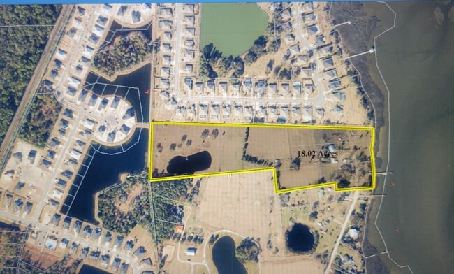
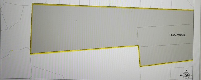
Property Record
96769 Oneil Scott Rd, Fernandina Beach, FL 32034
NEARBY LISTINGS FOR SALE OR LEASE
Property Detail
96769 Oneil Scott Rd
Jacksonville, FL
IN OR 738/1824 BOUNDARY AGMT PT OR 780/793 ESMT PT OR 1116/258
39-2N-28-0000-0001-0000
Nassau
Pasture
Florida
AE
1
12089C0219G
12.35 AC
2025
Nassau County
2025
Jacksonville (Florida)
050203
DEMOGRAPHICS near 96769 Oneil Scott Rd
1 Mile
3 Mile
5 Mile
2024 Total Population
2,069
19,377
53,206
2029 Population
2,522
23,538
64,699
Pop Growth 2024-2029
+ 21.89%
+ 21.47%
+ 21.60%
Average Age
46
44
47
2024 Total Households
820
7,764
22,346
HH Growth 2024-2029
+ 23.05%
+ 22.69%
+ 22.84%
Median Household Inc
$131,060
$93,061
$83,081
Avg Household Size
2.50
2.50
2.30
2024 Avg HH Vehicles
2.00
2.00
2.00
Median Home Value
$525,271
$359,306
$361,357
Median Year Built
2006
2009
2001
Nearby Places
Map Layers
Map Styles
 Street
 Aerial
- Restaurants
- Banks
- Shops
- Fitness
- Groceries
PUBLIC TRANSPORTATION
AIRPORT
Jacksonville International
DRIVE
WALK
Distance
Jacksonville International
36 min
19.7 mi
Freight Ports
Jacksonville Port
DRIVE
WALK
Distance
Jacksonville Port
46 min
31.2 mi
Nearby Properties
Address
Land Use
TOTAL SIZE
Lot Size
Zoning
Address
Land Use
TOTAL SIZE
Lot Size
Zoning
327,682 SF
24.09 AC
RG-2
Address
Land Use
TOTAL SIZE
Lot Size
Zoning
97,988 SF
513.95 AC
I-1
Address
Land Use
TOTAL SIZE
Lot Size
Zoning
282,898 SF
22.88 AC
RG-2
Address
Land Use
TOTAL SIZE
Lot Size
Zoning
221,536 SF
11.16 AC
C-2
Address
Land Use
TOTAL SIZE
Lot Size
Zoning
210,010 SF
19.36 AC
RG-1
Address
Land Use
TOTAL SIZE
Lot Size
Zoning
134,407 SF
2.77 AC
PUD
Address
Land Use
TOTAL SIZE
Lot Size
Zoning
Address
Land Use
TOTAL SIZE
Lot Size
Zoning
63,363 SF
10.41 AC
PUD
Address
Land Use
TOTAL SIZE
Lot Size
Zoning
66,417 SF
8.75 AC
PUD
Address
Land Use
TOTAL SIZE
Lot Size
Zoning
163,686 SF
28.08 AC
CI
Address
Land Use
TOTAL SIZE
Lot Size
Zoning
105,105 SF
2.65 AC
CG
Address
Land Use
TOTAL SIZE
Lot Size
Zoning
145,581 SF
3 AC
CG
Address
Land Use
TOTAL SIZE
Lot Size
Zoning
59,770 SF
8.51 AC
GPU
Address
Land Use
TOTAL SIZE
Lot Size
Zoning
48,863 SF
40.38 AC
RG-1
Address
Land Use
TOTAL SIZE
Lot Size
Zoning
125,733 SF
10.89 AC
IW
Address
Land Use
TOTAL SIZE
Lot Size
Zoning
109,094 SF
11.03 AC
IW
Address
Land Use
TOTAL SIZE
Lot Size
Zoning
54,600 SF
6.83 AC
RG-1
Address
Land Use
TOTAL SIZE
Lot Size
Zoning
44,933 SF
5.03 AC
PUD
Address
Land Use
TOTAL SIZE
Lot Size
Zoning
24.41 AC
IW
Address
Land Use
TOTAL SIZE
Lot Size
Zoning
89,600 SF
1.87 AC
CI
Address
Land Use
TOTAL SIZE
Lot Size
Zoning
44,734 SF
9.59 AC
OR
Address
Land Use
TOTAL SIZE
Lot Size
Zoning
35,296 SF
6.72 AC
PUD
Address
Land Use
TOTAL SIZE
Lot Size
Zoning
32,449 SF
7.57 AC
CI
Address
Land Use
TOTAL SIZE
Lot Size
Zoning
48,460 SF
14.60 AC
PUD
Address
Land Use
TOTAL SIZE
Lot Size
Zoning
50,286 SF
4.39 AC
PUD
Address
Land Use
TOTAL SIZE
Lot Size
Zoning
Address
Land Use
TOTAL SIZE
Lot Size
Zoning
35,463 SF
9.08 AC
PUD
Address
Land Use
TOTAL SIZE
Lot Size
Zoning
33,818 SF
2.88 AC
CI
Address
Land Use
TOTAL SIZE
Lot Size
Zoning
12,927 SF
8.03 AC
OR
Address
Land Use
TOTAL SIZE
Lot Size
Zoning
71.76 AC
OR
The World's #1 Commercial Real Estate Marketplace
Connect with us
© 2025 CoStar Group
The information above has been obtained from sources believed reliable. While we do not doubt its accuracy we have not verified it and make no guarantee, warranty or representation about it. It is your responsibility to independently confirm its accuracy and completeness. Any projections, opinions, assumptions, or estimates used are for example only and do not represent the current or future performance of the property. The value of this transaction to you depends on tax and other factors which should be evaluated by your tax, financial, and legal advisors. You and your advisors should conduct a careful, independent investigation of the property to determine to your satisfaction the suitability of the property for your needs.