Property Record
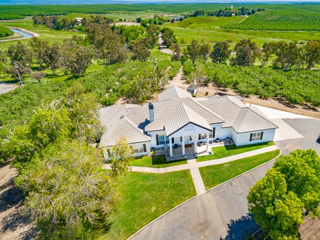
9677 Rodden Rd, Oakdale, CA 95361


NEARBY LISTINGS FOR SALE OR LEASE
Property Detail
9677 Rodden Rd
002-53-10
Providence 01
Agriculturalland
Stanislaus
X
California
06099C0190E
c
2025
55.80 AC
2025
Hughson/Oakdale/Waterford
000101
Stockton/Modesto
3,686 SF
Modesto, CA
DEMOGRAPHICS near 9677 Rodden Rd
1 Mile
3 Mile
5 Mile
2024 Total Population
194
12,229
28,906
2029 Population
187
12,225
28,880
Pop Growth 2024-2029
(3.61%)
(0.03%)
(0.09%)
Average Age
45
42
39
2024 Total Households
73
4,619
10,366
HH Growth 2024-2029
(4.11%)
(0.06%)
(0.12%)
Median Household Inc
$157,692
$86,743
$85,475
Avg Household Size
2.70
2.60
2.80
2024 Avg HH Vehicles
3.00
2.00
2.00
Median Home Value
$781,249
$456,670
$461,180
Median Year Built
1982
1991
1986
Nearby Places
Map Layers
Map Styles
 Street
 Aerial
- Restaurants
- Banks
- Shops
- Fitness
- Groceries
PUBLIC TRANSPORTATION
AIRPORT
Stockton Metro
DRIVE
WALK
Distance
Stockton Metro
58 min
28.7 mi
Freight Ports
Port of Stockton
DRIVE
WALK
Distance
Port of Stockton
67 min
39.6 mi
SALE & LEASE HISTORY
LISTING DATE
SALE/LEASE

Apr 23, 2020
For Sale
Nearby Properties
Address
Land Use
TOTAL SIZE
Lot Size
Zoning
Address
Land Use
TOTAL SIZE
Lot Size
Zoning
95,020 SF
9.82 AC
OAKPD
Address
Land Use
TOTAL SIZE
Lot Size
Zoning
45,337 SF
3.97 AC
OAKPSP
Address
Land Use
TOTAL SIZE
Lot Size
Zoning
11,411 SF
133.33 AC
COURA
Address
Land Use
TOTAL SIZE
Lot Size
Zoning
23,618 SF
2.93 AC
OAKPSP
Address
Land Use
TOTAL SIZE
Lot Size
Zoning
37,998 SF
2.80 AC
Address
Land Use
TOTAL SIZE
Lot Size
Zoning
86,549 SF
7.34 AC
Address
Land Use
TOTAL SIZE
Lot Size
Zoning
12,861 SF
1.34 AC
OAKC2
Address
Land Use
TOTAL SIZE
Lot Size
Zoning
25,575 SF
4.86 AC
C2
Address
Land Use
TOTAL SIZE
Lot Size
Zoning
50,250 SF
5.26 AC
OAKR2
Address
Land Use
TOTAL SIZE
Lot Size
Zoning
32,604 SF
23.08 AC
Address
Land Use
TOTAL SIZE
Lot Size
Zoning
27,483 SF
1.11 AC
Address
Land Use
TOTAL SIZE
Lot Size
Zoning
2,126 SF
57.71 AC
A240
Address
Land Use
TOTAL SIZE
Lot Size
Zoning
71,207 SF
3.26 AC
Address
Land Use
TOTAL SIZE
Lot Size
Zoning
18,432 SF
1.69 AC
Address
Land Use
TOTAL SIZE
Lot Size
Zoning
34,272 SF
5.78 AC
C2
Address
Land Use
TOTAL SIZE
Lot Size
Zoning
20,020 SF
2 AC
Address
Land Use
TOTAL SIZE
Lot Size
Zoning
153.13 AC
Address
Land Use
TOTAL SIZE
Lot Size
Zoning
91,072 SF
8.84 AC
OAKC2
Address
Land Use
TOTAL SIZE
Lot Size
Zoning
2,598 SF
0.45 AC
Address
Land Use
TOTAL SIZE
Lot Size
Zoning
1,344 SF
372.26 AC
A240
Address
Land Use
TOTAL SIZE
Lot Size
Zoning
58,734 SF
1.51 AC
Address
Land Use
TOTAL SIZE
Lot Size
Zoning
3,980 SF
215.60 AC
Address
Land Use
TOTAL SIZE
Lot Size
Zoning
13,644 SF
1.35 AC
Address
Land Use
TOTAL SIZE
Lot Size
Zoning
29,057 SF
1.01 AC
Address
Land Use
TOTAL SIZE
Lot Size
Zoning
22,817 SF
1.04 AC
C2
Address
Land Use
TOTAL SIZE
Lot Size
Zoning
79.16 AC
Address
Land Use
TOTAL SIZE
Lot Size
Zoning
2,551 SF
1.12 AC
Address
Land Use
TOTAL SIZE
Lot Size
Zoning
8,172 SF
41.04 AC
A240
Address
Land Use
TOTAL SIZE
Lot Size
Zoning
Address
Land Use
TOTAL SIZE
Lot Size
Zoning
10,600 SF
1.08 AC
The World's #1 Commercial Real Estate Marketplace
Connect with us
© 2025 CoStar Group
The information above has been obtained from sources believed reliable. While we do not doubt its accuracy we have not verified it and make no guarantee, warranty or representation about it. It is your responsibility to independently confirm its accuracy and completeness. Any projections, opinions, assumptions, or estimates used are for example only and do not represent the current or future performance of the property. The value of this transaction to you depends on tax and other factors which should be evaluated by your tax, financial, and legal advisors. You and your advisors should conduct a careful, independent investigation of the property to determine to your satisfaction the suitability of the property for your needs.