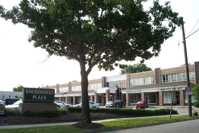
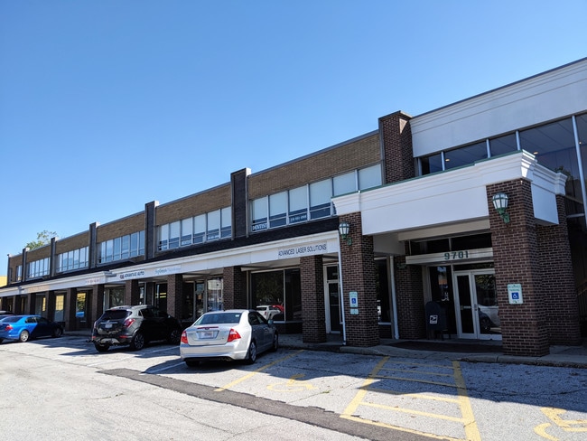
Property Record
9701 Brookpark Rd, Cleveland, OH 44129


Save to a Folder
{{folder.Name}}
{{folder.ListingIds.length}} Properties
{{folder.ListingIds.length}} Property
Create a New Folder
Current Lease Availabilities
Property Detail
9701 Brookpark Rd
442-08-001
CHENY O/L 1 EP 686.47FT WP
Stripcommercialcenter
CUYAHOGA
CB
Ohio
B and X Area of moderate flood hazard, usually the area between the limits of the 100-year and 500-year floods.
1
2025
1.29 AC
2025
Southwest
177103
Cleveland
42,305 SF
Cleveland-Elyria, OH
NEARBY LISTINGS FOR SALE OR LEASE
DEMOGRAPHICS near 9701 Brookpark Rd
1 mile
3 mile
5 mile
2025 Total Population
10,100
132,075
318,373
2030 Population
9,951
129,585
313,024
Pop Growth 2025-2030
(1.48%)
(1.89%)
(1.68%)
Average Age
43
41
41
2025 Total Households
4,598
57,204
140,005
HH Growth 2025-2030
(1.59%)
(2.01%)
(1.77%)
Median Household Inc
$71,956
$59,443
$59,809
Avg Household Size
2.10
2.20
2.20
2025 Avg HH Vehicles
2.00
2.00
2.00
Median Home Value
$162,710
$147,140
$165,189
Median Year Built
1958
1953
1952
Nearby Places
Map Layers
Map Styles
 Street
 Aerial
Layers
 Traffic
 Biking
Places
Listings with unknown addresses are not visible on the map
- Restaurants
- Banks
- Shops
- Fitness
- Groceries
PUBLIC TRANSPORTATION
COMMUTER RAIL
Rockside (National Park Scenic Railway - Cuyahoga Valley Scenic Railroad)
Drive
Walk
Distance
Rockside (National Park Scenic Railway - Cuyahoga Valley Scenic Railroad)
15 min
8.1 mi
Cleveland Lakefront Station (Blue Line - Greater Cleveland Regional Transit Authority Rapid Transit (The Rapid), Green Line - Greater Cleveland Regional Transit Authority Rapid Transit (The Rapid))
Drive
Walk
Distance
Cleveland Lakefront Station (Blue Line - Greater Cleveland Regional Transit Authority Rapid Transit (The Rapid), Green Line - Greater Cleveland Regional Transit Authority Rapid Transit (The Rapid))
20 min
9.4 mi
AIRPORT
Cleveland-Hopkins International
Drive
Walk
Distance
Cleveland-Hopkins International
13 min
5.9 mi
Freight Ports
Port of Toledo
Drive
Walk
Distance
Port of Toledo
128 min
107.2 mi
Nearby Properties
Address
Land Use
TOTAL SIZE
Lot Size
Zoning
Address
Land Use
TOTAL SIZE
Lot Size
Zoning
477,641 SF
14.07 AC
MF-1
Address
Land Use
TOTAL SIZE
Lot Size
Zoning
70.02 AC
GI
Address
Land Use
TOTAL SIZE
Lot Size
Zoning
245,255 SF
14 AC
Address
Land Use
TOTAL SIZE
Lot Size
Zoning
208,209 SF
12.10 AC
1F
Address
Land Use
TOTAL SIZE
Lot Size
Zoning
809,240 SF
36.27 AC
L-I
Address
Land Use
TOTAL SIZE
Lot Size
Zoning
632,686 SF
16.44 AC
MF-3
Address
Land Use
TOTAL SIZE
Lot Size
Zoning
33.27 AC
IA
Address
Land Use
TOTAL SIZE
Lot Size
Zoning
355,701 SF
16.35 AC
OB
Address
Land Use
TOTAL SIZE
Lot Size
Zoning
519,592 SF
69.70 AC
L-I
Address
Land Use
TOTAL SIZE
Lot Size
Zoning
372,486 SF
3.98 AC
GR
Address
Land Use
TOTAL SIZE
Lot Size
Zoning
361,287 SF
86.50 AC
2F
Address
Land Use
TOTAL SIZE
Lot Size
Zoning
78,622 SF
11.78 AC
CB
Address
Land Use
TOTAL SIZE
Lot Size
Zoning
132.06 AC
IA
Address
Land Use
TOTAL SIZE
Lot Size
Zoning
389,067 SF
12.05 AC
A-H
Address
Land Use
TOTAL SIZE
Lot Size
Zoning
86,081 SF
14.45 AC
B
Address
Land Use
TOTAL SIZE
Lot Size
Zoning
111,220 SF
23.65 AC
IA
Address
Land Use
TOTAL SIZE
Lot Size
Zoning
76,288 SF
258.02 AC
PG
Address
Land Use
TOTAL SIZE
Lot Size
Zoning
340,593 SF
10.10 AC
G-1
Address
Land Use
TOTAL SIZE
Lot Size
Zoning
83,375 SF
9.29 AC
MF-1
Address
Land Use
TOTAL SIZE
Lot Size
Zoning
87,489 SF
8.01 AC
Address
Land Use
TOTAL SIZE
Lot Size
Zoning
32,820 SF
3.60 AC
U7-B
Address
Land Use
TOTAL SIZE
Lot Size
Zoning
74,731 SF
15.23 AC
A
Address
Land Use
TOTAL SIZE
Lot Size
Zoning
88,328 SF
35.11 AC
RM
Address
Land Use
TOTAL SIZE
Lot Size
Zoning
16,023 SF
18.41 AC
SF-DH
Address
Land Use
TOTAL SIZE
Lot Size
Zoning
239,222 SF
22.87 AC
G-B
Address
Land Use
TOTAL SIZE
Lot Size
Zoning
208,675 SF
17.33 AC
G-B
Address
Land Use
TOTAL SIZE
Lot Size
Zoning
154,579 SF
18.46 AC
A
Address
Land Use
TOTAL SIZE
Lot Size
Zoning
250,995 SF
15.94 AC
IP
Address
Land Use
TOTAL SIZE
Lot Size
Zoning
107,240 SF
19.19 AC
MF-1
Address
Land Use
TOTAL SIZE
Lot Size
Zoning
137,686 SF
12.02 AC
A-H
The World's #1 Commercial Real Estate Marketplace
Connect with us
© 2026 CoStar Group
The information above has been obtained from sources believed reliable. While we do not doubt its accuracy we have not verified it and make no guarantee, warranty or representation about it. It is your responsibility to independently confirm its accuracy and completeness. Any projections, opinions, assumptions, or estimates used are for example only and do not represent the current or future performance of the property. The value of this transaction to you depends on tax and other factors which should be evaluated by your tax, financial, and legal advisors. You and your advisors should conduct a careful, independent investigation of the property to determine to your satisfaction the suitability of the property for your needs.