Property Record
9680 Argyle Forest Blvd, Jacksonville, FL 32222
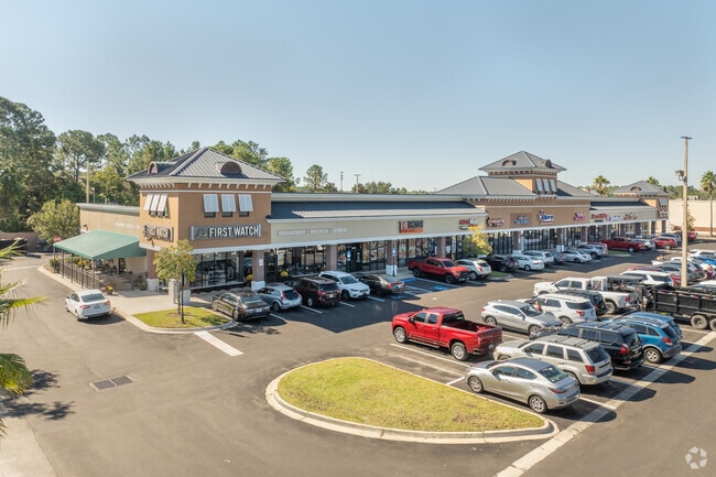


Property Detail
9680 Argyle Forest Blvd
016411-4510
32-3S-25E 2.538 PT OF SW1/4 RECD O/R 21387-2277 BEING PARCEL 2
Regionalshoppingcenterormallwithanchorstore
Duval
PUD
Florida
B and X Area of moderate flood hazard, usually the area between the limits of the 100-year and 500-year floods.
2.54 AC
2025
Riverside
2026
Jacksonville (Florida)
013723
Jacksonville, FL
25,322 SF
NEARBY LISTINGS FOR SALE OR LEASE
DEMOGRAPHICS near 9680 Argyle Forest Blvd
1 mile
3 mile
5 mile
2025 Total Population
8,300
56,513
115,927
2030 Population
9,055
60,801
124,078
Pop Growth 2025-2030
+ 9.10%
+ 7.59%
+ 7.03%
Average Age
37
37
38
2025 Total Households
2,974
19,118
40,897
HH Growth 2025-2030
+ 9.52%
+ 7.93%
+ 7.27%
Median Household Inc
$96,993
$99,770
$83,424
Avg Household Size
2.80
2.90
2.80
2025 Avg HH Vehicles
2.00
2.00
2.00
Median Home Value
$339,862
$332,083
$313,971
Median Year Built
2010
2005
2001
Nearby Places
Map Layers
Map Styles
 Street
 Aerial
Layers
 Traffic
 Biking
Places
Listings with unknown addresses are not visible on the map
- Restaurants
- Banks
- Shops
- Fitness
- Groceries
PUBLIC TRANSPORTATION
AIRPORT
Jacksonville International
Drive
Walk
Distance
Jacksonville International
46 min
27.5 mi
Freight Ports
Jacksonville Port
Drive
Walk
Distance
Jacksonville Port
39 min
20.1 mi
SALE & LEASE HISTORY
LISTING DATE
SALE/LEASE

Oct 11, 2021
For Lease
Jul 31, 2019
For Lease
Jan 23, 2020
For Lease
Nearby Properties
Address
Land Use
TOTAL SIZE
Lot Size
Zoning
Address
Land Use
TOTAL SIZE
Lot Size
Zoning
365,663 SF
23.12 AC
PUD
Address
Land Use
TOTAL SIZE
Lot Size
Zoning
264,898 SF
17.50 AC
Address
Land Use
TOTAL SIZE
Lot Size
Zoning
284,061 SF
19.48 AC
PUD
Address
Land Use
TOTAL SIZE
Lot Size
Zoning
242,778 SF
14.51 AC
PUD
Address
Land Use
TOTAL SIZE
Lot Size
Zoning
150,882 SF
109.60 AC
Address
Land Use
TOTAL SIZE
Lot Size
Zoning
146,640 SF
3.90 AC
Address
Land Use
TOTAL SIZE
Lot Size
Zoning
146,640 SF
5.43 AC
Address
Land Use
TOTAL SIZE
Lot Size
Zoning
168,818 SF
17.64 AC
PUD
Address
Land Use
TOTAL SIZE
Lot Size
Zoning
133,592 SF
37.12 AC
Address
Land Use
TOTAL SIZE
Lot Size
Zoning
156,028 SF
10.58 AC
PUD
Address
Land Use
TOTAL SIZE
Lot Size
Zoning
132,912 SF
30.12 AC
Address
Land Use
TOTAL SIZE
Lot Size
Zoning
31,812 SF
8.80 AC
PUD
Address
Land Use
TOTAL SIZE
Lot Size
Zoning
98,675 SF
24.30 AC
Address
Land Use
TOTAL SIZE
Lot Size
Zoning
117,736 SF
3.97 AC
Address
Land Use
TOTAL SIZE
Lot Size
Zoning
142,830 SF
5.46 AC
Address
Land Use
TOTAL SIZE
Lot Size
Zoning
147,613 SF
15.68 AC
PUD
Address
Land Use
TOTAL SIZE
Lot Size
Zoning
159,296 SF
20.54 AC
PUD
Address
Land Use
TOTAL SIZE
Lot Size
Zoning
74,468 SF
14.47 AC
Address
Land Use
TOTAL SIZE
Lot Size
Zoning
187,550 SF
13.44 AC
PUD
Address
Land Use
TOTAL SIZE
Lot Size
Zoning
93,150 SF
4.82 AC
Address
Land Use
TOTAL SIZE
Lot Size
Zoning
81,842 SF
8.41 AC
PUD
Address
Land Use
TOTAL SIZE
Lot Size
Zoning
103,301 SF
2.94 AC
Address
Land Use
TOTAL SIZE
Lot Size
Zoning
139,137 SF
18.08 AC
PUD
Address
Land Use
TOTAL SIZE
Lot Size
Zoning
79,870 SF
7.41 AC
PUD
Address
Land Use
TOTAL SIZE
Lot Size
Zoning
69,960 SF
15.36 AC
Address
Land Use
TOTAL SIZE
Lot Size
Zoning
117,401 SF
17.02 AC
PUD
Address
Land Use
TOTAL SIZE
Lot Size
Zoning
102,959 SF
5.58 AC
PUD
Address
Land Use
TOTAL SIZE
Lot Size
Zoning
2,406 SF
48.93 AC
Address
Land Use
TOTAL SIZE
Lot Size
Zoning
56,264 SF
6.10 AC
PUD
Address
Land Use
TOTAL SIZE
Lot Size
Zoning
12,585 SF
20.16 AC
The World's #1 Commercial Real Estate Marketplace
Connect with us
© 2026 CoStar Group
The information above has been obtained from sources believed reliable. While we do not doubt its accuracy we have not verified it and make no guarantee, warranty or representation about it. It is your responsibility to independently confirm its accuracy and completeness. Any projections, opinions, assumptions, or estimates used are for example only and do not represent the current or future performance of the property. The value of this transaction to you depends on tax and other factors which should be evaluated by your tax, financial, and legal advisors. You and your advisors should conduct a careful, independent investigation of the property to determine to your satisfaction the suitability of the property for your needs.