Property Record
969 N 3050 E, Saint George, UT 84790
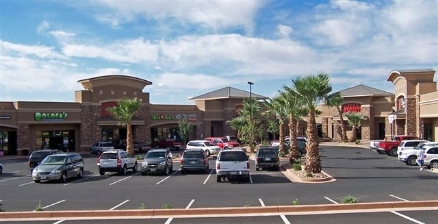

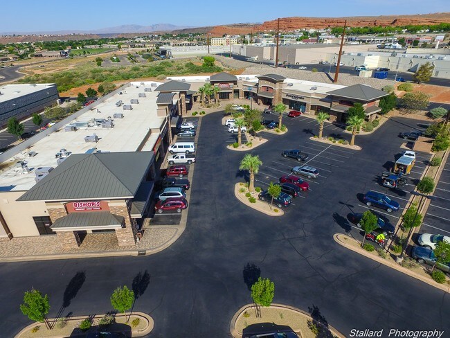
Property Detail
969 N 3050 E
0813216
SUBDIVISION: MILL CREEK COMMERCIAL CENTER 3RD AMD & EXT (SG) LOT: 1-C
Commercialnec
Washington
C-3
Utah
B and X Area of moderate flood hazard, usually the area between the limits of the 100-year and 500-year floods.
1
2023
3.85 AC
2025
Cedar City & St George
271101
Other Market Areas
35,139 SF
St. George, UT
NEARBY LISTINGS FOR SALE OR LEASE
DEMOGRAPHICS near 969 N 3050 E
1 mile
3 mile
5 mile
2025 Total Population
10,421
50,991
95,431
2030 Population
11,387
56,074
104,840
Pop Growth 2025-2030
+ 9.27%
+ 9.97%
+ 9.86%
Average Age
39
39
39
2025 Total Households
3,718
17,717
32,607
HH Growth 2025-2030
+ 9.98%
+ 10.42%
+ 10.22%
Median Household Inc
$69,345
$72,681
$75,179
Avg Household Size
2.70
2.80
2.80
2025 Avg HH Vehicles
2.00
2.00
2.00
Median Home Value
$507,620
$515,925
$552,114
Median Year Built
2001
2004
2003
Nearby Places
Map Layers
Map Styles
 Street
 Aerial
Layers
 Traffic
 Biking
Places
Listings with unknown addresses are not visible on the map
- Restaurants
- Banks
- Shops
- Fitness
- Groceries
PUBLIC TRANSPORTATION
AIRPORT
St George Regional
Drive
Walk
Distance
St George Regional
14 min
6.0 mi
SALE & LEASE HISTORY
LISTING DATE
SALE/LEASE

Sep 25, 2016
For Lease
Jun 30, 2023
For Lease
Dec 30, 2019
For Sale
Apr 28, 2017
For Sale
Nearby Properties
Address
Land Use
TOTAL SIZE
Lot Size
Zoning
Address
Land Use
TOTAL SIZE
Lot Size
Zoning
1,120,988 SF
52.22 AC
PDCOM
Address
Land Use
TOTAL SIZE
Lot Size
Zoning
319,351 SF
31.39 AC
Address
Land Use
TOTAL SIZE
Lot Size
Zoning
319,351 SF
31.39 AC
PD
Address
Land Use
TOTAL SIZE
Lot Size
Zoning
1,319 SF
549.51 AC
Address
Land Use
TOTAL SIZE
Lot Size
Zoning
118,603 SF
16.56 AC
Address
Land Use
TOTAL SIZE
Lot Size
Zoning
141,151 SF
15 AC
PDCOM
Address
Land Use
TOTAL SIZE
Lot Size
Zoning
230,880 SF
25.58 AC
C-2
Address
Land Use
TOTAL SIZE
Lot Size
Zoning
87,826 SF
37.27 AC
Address
Land Use
TOTAL SIZE
Lot Size
Zoning
66,506 SF
15.12 AC
Address
Land Use
TOTAL SIZE
Lot Size
Zoning
97,572 SF
10.51 AC
PD
Address
Land Use
TOTAL SIZE
Lot Size
Zoning
91,517 SF
8.96 AC
C2
Address
Land Use
TOTAL SIZE
Lot Size
Zoning
84,384 SF
6.34 AC
C2
Address
Land Use
TOTAL SIZE
Lot Size
Zoning
88,445 SF
3.28 AC
C2
Address
Land Use
TOTAL SIZE
Lot Size
Zoning
86,875 SF
77.53 AC
Address
Land Use
TOTAL SIZE
Lot Size
Zoning
153,140 SF
17.17 AC
C-3
Address
Land Use
TOTAL SIZE
Lot Size
Zoning
120,219 SF
11.88 AC
Address
Land Use
TOTAL SIZE
Lot Size
Zoning
67,974 SF
7.04 AC
Address
Land Use
TOTAL SIZE
Lot Size
Zoning
76,907 SF
4 AC
PDCOM
Address
Land Use
TOTAL SIZE
Lot Size
Zoning
72,862 SF
3.20 AC
Address
Land Use
TOTAL SIZE
Lot Size
Zoning
99,566 SF
5.64 AC
Address
Land Use
TOTAL SIZE
Lot Size
Zoning
137,662 SF
7.81 AC
PD
Address
Land Use
TOTAL SIZE
Lot Size
Zoning
69,421 SF
5.73 AC
PDCOM
Address
Land Use
TOTAL SIZE
Lot Size
Zoning
34,097 SF
5.90 AC
Address
Land Use
TOTAL SIZE
Lot Size
Zoning
125,208 SF
4.15 AC
PDCOM
Address
Land Use
TOTAL SIZE
Lot Size
Zoning
58,937 SF
4.47 AC
C2
Address
Land Use
TOTAL SIZE
Lot Size
Zoning
135,592 SF
11.24 AC
PDCOM
Address
Land Use
TOTAL SIZE
Lot Size
Zoning
111,865 SF
5 AC
M-2
Address
Land Use
TOTAL SIZE
Lot Size
Zoning
71,533 SF
6.48 AC
C3
Address
Land Use
TOTAL SIZE
Lot Size
Zoning
88,962 SF
8.35 AC
C-3
Address
Land Use
TOTAL SIZE
Lot Size
Zoning
54,754 SF
3.17 AC
AP
The World's #1 Commercial Real Estate Marketplace
Connect with us
© 2026 CoStar Group
The information above has been obtained from sources believed reliable. While we do not doubt its accuracy we have not verified it and make no guarantee, warranty or representation about it. It is your responsibility to independently confirm its accuracy and completeness. Any projections, opinions, assumptions, or estimates used are for example only and do not represent the current or future performance of the property. The value of this transaction to you depends on tax and other factors which should be evaluated by your tax, financial, and legal advisors. You and your advisors should conduct a careful, independent investigation of the property to determine to your satisfaction the suitability of the property for your needs.