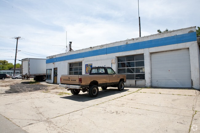
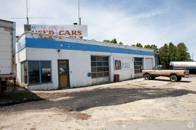
Property Record
969 Shawmut Ave, New Bedford, MA 02746

Save to a Folder
{{folder.Name}}
{{folder.ListingIds.length}} Properties
{{folder.ListingIds.length}} Property
Create a New Folder
Property Detail
969 Shawmut Ave
NEWB-000121-000000-000063
Bristol
Commercialbuilding
Massachusetts
IB
63
B and X Area of moderate flood hazard, usually the area between the limits of the 100-year and 500-year floods.
3.52 AC
2025
Attleboro/New Bedford
2025
Boston
651001
Providence-Warwick, RI-MA
77,176 SF
NEARBY LISTINGS FOR SALE OR LEASE
DEMOGRAPHICS near 969 Shawmut Ave
1 mile
3 mile
5 mile
2025 Total Population
13,512
91,332
139,960
2030 Population
13,410
91,043
140,246
Pop Growth 2025-2030
(0.75%)
(0.32%)
+ 0.20%
Average Age
37
41
41
2025 Total Households
5,321
37,972
57,284
HH Growth 2025-2030
(0.79%)
(0.30%)
+ 0.24%
Median Household Inc
$45,884
$59,240
$64,459
Avg Household Size
2.40
2.30
2.30
2025 Avg HH Vehicles
1.00
1.00
2.00
Median Home Value
$339,363
$369,405
$403,061
Median Year Built
1948
1948
1950
Nearby Places
Map Layers
Map Styles
 Street
 Aerial
Layers
 Traffic
 Biking
Places
Listings with unknown addresses are not visible on the map
- Restaurants
- Banks
- Shops
- Fitness
- Groceries
PUBLIC TRANSPORTATION
AIRPORT
Rhode Island Tf Green International
Drive
Walk
Distance
Rhode Island Tf Green International
51 min
36.1 mi
Freight Ports
Port of New Bedford Harbor
Drive
Walk
Distance
Port of New Bedford Harbor
6 min
3.0 mi
SALE & LEASE HISTORY
LISTING DATE
SALE/LEASE

Sep 26, 2016
For Lease
May 22, 2017
For Sale
Jun 11, 2019
For Sale
Jun 05, 2020
For Lease
Nearby Properties
Address
Land Use
TOTAL SIZE
Lot Size
Zoning
Address
Land Use
TOTAL SIZE
Lot Size
Zoning
10.29 AC
RA
Address
Land Use
TOTAL SIZE
Lot Size
Zoning
23.22 AC
RB
Address
Land Use
TOTAL SIZE
Lot Size
Zoning
40.61 AC
GB
Address
Land Use
TOTAL SIZE
Lot Size
Zoning
23.71 AC
RA
Address
Land Use
TOTAL SIZE
Lot Size
Zoning
252,482 SF
11.56 AC
RA
Address
Land Use
TOTAL SIZE
Lot Size
Zoning
243,052 SF
9.66 AC
RB
Address
Land Use
TOTAL SIZE
Lot Size
Zoning
104.64 AC
LI
Address
Land Use
TOTAL SIZE
Lot Size
Zoning
269,020 SF
2.26 AC
MUB
Address
Land Use
TOTAL SIZE
Lot Size
Zoning
102,826 SF
15.15 AC
OI
Address
Land Use
TOTAL SIZE
Lot Size
Zoning
74.70 AC
SRA
Address
Land Use
TOTAL SIZE
Lot Size
Zoning
30.28 AC
GB
Address
Land Use
TOTAL SIZE
Lot Size
Zoning
40.65 AC
GB
Address
Land Use
TOTAL SIZE
Lot Size
Zoning
194,474 SF
11.57 AC
RA
Address
Land Use
TOTAL SIZE
Lot Size
Zoning
231,634 SF
2.45 AC
IB
Address
Land Use
TOTAL SIZE
Lot Size
Zoning
284,742 SF
17.14 AC
RB
Address
Land Use
TOTAL SIZE
Lot Size
Zoning
120,533 SF
13.83 AC
OI
Address
Land Use
TOTAL SIZE
Lot Size
Zoning
160,391 SF
2.86 AC
MUB
Address
Land Use
TOTAL SIZE
Lot Size
Zoning
214,698 SF
4.66 AC
IB
Address
Land Use
TOTAL SIZE
Lot Size
Zoning
24.95 AC
PB
Address
Land Use
TOTAL SIZE
Lot Size
Zoning
127,514 SF
4.23 AC
MUB
Address
Land Use
TOTAL SIZE
Lot Size
Zoning
11.67 AC
RC
Address
Land Use
TOTAL SIZE
Lot Size
Zoning
188,739 SF
2.57 AC
IB
Address
Land Use
TOTAL SIZE
Lot Size
Zoning
116,441 SF
11.74 AC
OFD
Address
Land Use
TOTAL SIZE
Lot Size
Zoning
15.97 AC
GB
Address
Land Use
TOTAL SIZE
Lot Size
Zoning
134,355 SF
2.21 AC
IB
Address
Land Use
TOTAL SIZE
Lot Size
Zoning
5.59 AC
RC
Address
Land Use
TOTAL SIZE
Lot Size
Zoning
183,450 SF
2.51 AC
RA
Address
Land Use
TOTAL SIZE
Lot Size
Zoning
183,196 SF
8.14 AC
MUB
Address
Land Use
TOTAL SIZE
Lot Size
Zoning
146,081 SF
2.15 AC
MUB
Address
Land Use
TOTAL SIZE
Lot Size
Zoning
492.70 AC
IC
The World's #1 Commercial Real Estate Marketplace
Connect with us
© 2026 CoStar Group
The information above has been obtained from sources believed reliable. While we do not doubt its accuracy we have not verified it and make no guarantee, warranty or representation about it. It is your responsibility to independently confirm its accuracy and completeness. Any projections, opinions, assumptions, or estimates used are for example only and do not represent the current or future performance of the property. The value of this transaction to you depends on tax and other factors which should be evaluated by your tax, financial, and legal advisors. You and your advisors should conduct a careful, independent investigation of the property to determine to your satisfaction the suitability of the property for your needs.