Property Record
969 W Main St, Catskill, NY 12414
NEARBY LISTINGS FOR SALE OR LEASE
Property Detail
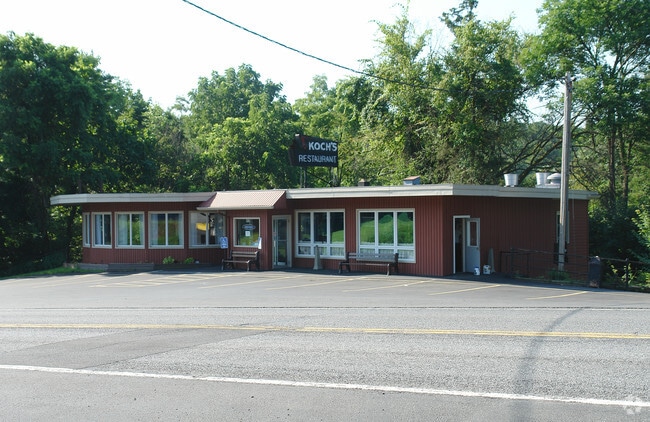
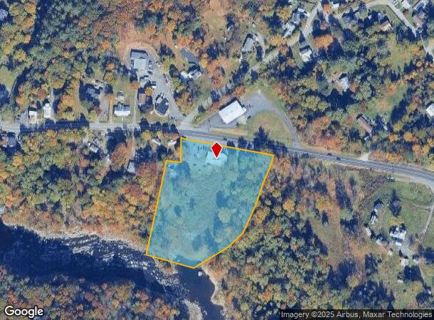
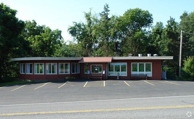
969 W Main St
Restaurantbuilding
Greene
AE
New York
36039C0269F
6.000
2025
4.10 AC
2024
Greene County
081102
Albany/Schenectady/Troy
3,217 SF
192689-138-011-0004-006-000-0000
DEMOGRAPHICS near 969 W Main St
1 Mile
3 Mile
5 Mile
2024 Total Population
499
6,778
14,422
2029 Population
503
6,909
14,699
Pop Growth 2024-2029
+ 0.80%
+ 1.93%
+ 1.92%
Average Age
44
45
45
2024 Total Households
219
3,013
6,460
HH Growth 2024-2029
+ 0.91%
+ 1.86%
+ 1.84%
Median Household Inc
$80,488
$57,072
$59,853
Avg Household Size
2.20
2.10
2.10
2024 Avg HH Vehicles
2.00
2.00
2.00
Median Home Value
$228,723
$181,543
$201,390
Median Year Built
1969
1952
1960
Nearby Places
- Restaurants
- Banks
- Shops
- Fitness
- Groceries
PUBLIC TRANSPORTATION
COMMUTER RAIL
DRIVE
WALK
Distance
15 min
8.0 mi
DRIVE
WALK
Distance
15 min
8.0 mi
AIRPORT
Albany International
DRIVE
WALK
Distance
Albany International
57 min
42.6 mi
Freight Ports
Albany, NY Port
DRIVE
WALK
Distance
Albany, NY Port
38 min
29.4 mi
Nearby Properties
Address
Land Use
TOTAL SIZE
Lot Size
Zoning
Address
Land Use
TOTAL SIZE
Lot Size
Zoning
83.45 AC
02 - SINGL
Address
Land Use
TOTAL SIZE
Lot Size
Zoning
126.10 AC
02 - SINGL
Address
Land Use
TOTAL SIZE
Lot Size
Zoning
108,000 SF
1.30 AC
05 - COMME
Address
Land Use
TOTAL SIZE
Lot Size
Zoning
217,226 SF
19.20 AC
02 - SINGL
Address
Land Use
TOTAL SIZE
Lot Size
Zoning
175,908 SF
31.10 AC
03 - MULTI
Address
Land Use
TOTAL SIZE
Lot Size
Zoning
63,071 SF
8.08 AC
02 - SINGL
Address
Land Use
TOTAL SIZE
Lot Size
Zoning
120,765 SF
5.34 AC
05 - COMME
Address
Land Use
TOTAL SIZE
Lot Size
Zoning
15,750 SF
77.20 AC
02 - SINGL
Address
Land Use
TOTAL SIZE
Lot Size
Zoning
Address
Land Use
TOTAL SIZE
Lot Size
Zoning
103,792 SF
25.84 AC
02 - SINGL
Address
Land Use
TOTAL SIZE
Lot Size
Zoning
Address
Land Use
TOTAL SIZE
Lot Size
Zoning
22,954 SF
144.64 AC
02 - SINGL
Address
Land Use
TOTAL SIZE
Lot Size
Zoning
Address
Land Use
TOTAL SIZE
Lot Size
Zoning
13,900 SF
11.50 AC
02 - SINGL
Address
Land Use
TOTAL SIZE
Lot Size
Zoning
10.88 AC
02 - SINGL
Address
Land Use
TOTAL SIZE
Lot Size
Zoning
Address
Land Use
TOTAL SIZE
Lot Size
Zoning
Address
Land Use
TOTAL SIZE
Lot Size
Zoning
4,524 SF
156.66 AC
04 - FARM
Address
Land Use
TOTAL SIZE
Lot Size
Zoning
18,250 SF
1.24 AC
05 - COMME
Address
Land Use
TOTAL SIZE
Lot Size
Zoning
14,550 SF
1.80 AC
02 - SINGL
Address
Land Use
TOTAL SIZE
Lot Size
Zoning
20,000 SF
2.61 AC
02 - SINGL
Address
Land Use
TOTAL SIZE
Lot Size
Zoning
21,921 SF
95.10 AC
08 - GOVER
Address
Land Use
TOTAL SIZE
Lot Size
Zoning
23,103 SF
3.63 AC
05 - COMME
Address
Land Use
TOTAL SIZE
Lot Size
Zoning
1,106 SF
20.51 AC
07 - MIXED
Address
Land Use
TOTAL SIZE
Lot Size
Zoning
67 AC
06 - INDUS
Address
Land Use
TOTAL SIZE
Lot Size
Zoning
960 SF
57.60 AC
99
Address
Land Use
TOTAL SIZE
Lot Size
Zoning
37,590 SF
0.87 AC
9
Address
Land Use
TOTAL SIZE
Lot Size
Zoning
Address
Land Use
TOTAL SIZE
Lot Size
Zoning
18,096 SF
6.10 AC
10
Address
Land Use
TOTAL SIZE
Lot Size
Zoning
20,808 SF
31 AC
06 - INDUS
The World's #1 Commercial Real Estate Marketplace
Connect with us
© 2025 CoStar Group
The information above has been obtained from sources believed reliable. While we do not doubt its accuracy we have not verified it and make no guarantee, warranty or representation about it. It is your responsibility to independently confirm its accuracy and completeness. Any projections, opinions, assumptions, or estimates used are for example only and do not represent the current or future performance of the property. The value of this transaction to you depends on tax and other factors which should be evaluated by your tax, financial, and legal advisors. You and your advisors should conduct a careful, independent investigation of the property to determine to your satisfaction the suitability of the property for your needs.