Property Record
9686 Marlboro Pike, Upper Marlboro, MD 20772


This Property Is For Sale
NEARBY LISTINGS FOR SALE OR LEASE
Property Detail
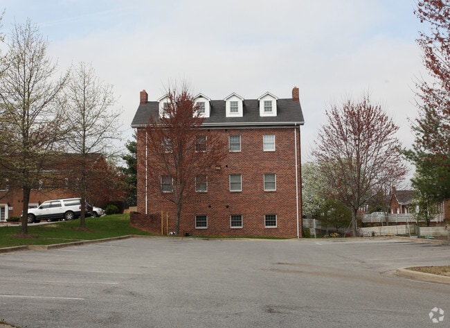
9686 Marlboro Pike
15-3074150
MELWOOD TOWNHOUSE
Commercialcondominium
Prince George's
X
Maryland
24033C0255E
0.08 AC
2023
Pennsylvania Ave Corridor
2025
Washington, DC
800707
Washington-Arlington-Alexandria, DC-VA-MD-WV
1,028 SF
DEMOGRAPHICS near 9686 Marlboro Pike
1 Mile
3 Mile
5 Mile
2024 Total Population
4,461
30,051
144,848
2029 Population
4,436
29,887
141,540
Pop Growth 2024-2029
(0.56%)
(0.55%)
(2.28%)
Average Age
42
40
41
2024 Total Households
1,686
10,903
54,473
HH Growth 2024-2029
(0.65%)
(0.58%)
(2.36%)
Median Household Inc
$150,322
$121,549
$100,361
Avg Household Size
2.60
2.70
2.60
2024 Avg HH Vehicles
2.00
2.00
2.00
Median Home Value
$487,760
$446,393
$366,211
Median Year Built
2006
1997
1983
Nearby Places
Map Layers
Map Styles
 Street
 Aerial
- Restaurants
- Banks
- Shops
- Fitness
- Groceries
PUBLIC TRANSPORTATION
AIRPORT
Ronald Reagan Washington Ntl
DRIVE
WALK
Distance
Ronald Reagan Washington Ntl
29 min
16.0 mi
Baltimore/Washington International Thurgood Marshall
DRIVE
WALK
Distance
Baltimore/Washington International Thurgood Marshall
50 min
33.7 mi
Freight Ports
Port of Baltimore
DRIVE
WALK
Distance
Port of Baltimore
60 min
40.3 mi
Nearby Properties
Address
Land Use
TOTAL SIZE
Lot Size
Zoning
Address
Land Use
TOTAL SIZE
Lot Size
Zoning
203.33 AC
IE
Address
Land Use
TOTAL SIZE
Lot Size
Zoning
386,775 SF
45.40 AC
RMF20
Address
Land Use
TOTAL SIZE
Lot Size
Zoning
111.87 AC
IE
Address
Land Use
TOTAL SIZE
Lot Size
Zoning
98.14 AC
IE
Address
Land Use
TOTAL SIZE
Lot Size
Zoning
223,600 SF
13.34 AC
IE
Address
Land Use
TOTAL SIZE
Lot Size
Zoning
117.45 AC
IE
Address
Land Use
TOTAL SIZE
Lot Size
Zoning
124.59 AC
IE
Address
Land Use
TOTAL SIZE
Lot Size
Zoning
4,059 SF
16.82 AC
IE
Address
Land Use
TOTAL SIZE
Lot Size
Zoning
133,840 SF
33.35 AC
IE
Address
Land Use
TOTAL SIZE
Lot Size
Zoning
111.72 AC
IE
Address
Land Use
TOTAL SIZE
Lot Size
Zoning
117.87 AC
IE
Address
Land Use
TOTAL SIZE
Lot Size
Zoning
269.41 AC
IE
Address
Land Use
TOTAL SIZE
Lot Size
Zoning
157.68 AC
IE
Address
Land Use
TOTAL SIZE
Lot Size
Zoning
138.27 AC
IE
Address
Land Use
TOTAL SIZE
Lot Size
Zoning
358,700 SF
12.24 AC
TACE
Address
Land Use
TOTAL SIZE
Lot Size
Zoning
250.35 AC
IE
Address
Land Use
TOTAL SIZE
Lot Size
Zoning
216,875 SF
8.75 AC
IE
Address
Land Use
TOTAL SIZE
Lot Size
Zoning
207,504 SF
8.84 AC
I1
Address
Land Use
TOTAL SIZE
Lot Size
Zoning
115,888 SF
12.36 AC
CGO
Address
Land Use
TOTAL SIZE
Lot Size
Zoning
116,550 SF
15.60 AC
IE
Address
Land Use
TOTAL SIZE
Lot Size
Zoning
102 AC
IE
Address
Land Use
TOTAL SIZE
Lot Size
Zoning
166,425 SF
10.51 AC
IE
Address
Land Use
TOTAL SIZE
Lot Size
Zoning
126,296 SF
34.87 AC
IE
Address
Land Use
TOTAL SIZE
Lot Size
Zoning
67.32 AC
IE
Address
Land Use
TOTAL SIZE
Lot Size
Zoning
115,500 SF
3.10 AC
IE
Address
Land Use
TOTAL SIZE
Lot Size
Zoning
169.75 AC
IE
Address
Land Use
TOTAL SIZE
Lot Size
Zoning
83.26 AC
IE
Address
Land Use
TOTAL SIZE
Lot Size
Zoning
102,218 SF
15.91 AC
IE
Address
Land Use
TOTAL SIZE
Lot Size
Zoning
152,400 SF
23.66 AC
IE
Address
Land Use
TOTAL SIZE
Lot Size
Zoning
200.65 AC
IE
The World's #1 Commercial Real Estate Marketplace
Connect with us
© 2026 CoStar Group
The information above has been obtained from sources believed reliable. While we do not doubt its accuracy we have not verified it and make no guarantee, warranty or representation about it. It is your responsibility to independently confirm its accuracy and completeness. Any projections, opinions, assumptions, or estimates used are for example only and do not represent the current or future performance of the property. The value of this transaction to you depends on tax and other factors which should be evaluated by your tax, financial, and legal advisors. You and your advisors should conduct a careful, independent investigation of the property to determine to your satisfaction the suitability of the property for your needs.