Property Record
9695 Adams St, Holland, MI 49424
NEARBY LISTINGS FOR SALE OR LEASE
Property Detail
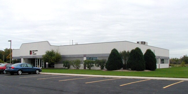
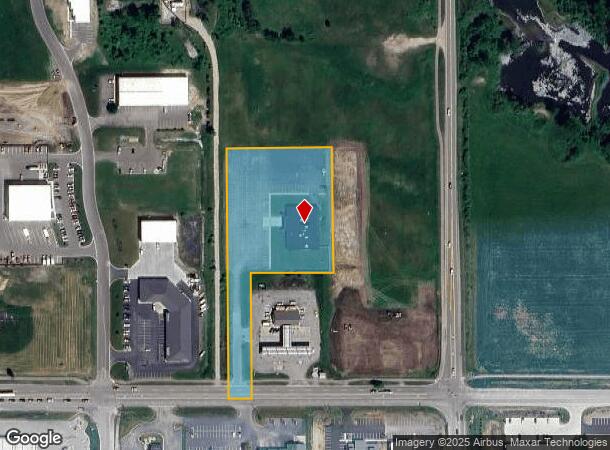
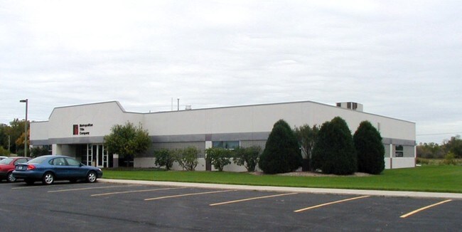
9695 Adams St
Grand Rapids-Wyoming, MI
Adams Street Sub
70-16-25-400-028
W 305 FT OF S 720 FT OF E 1/2 OF SE 1/4 OF SE 1/4 EXC LOT 1 ADAMS STREET SUB SEC 25 T5N R15W FROM 21-400-022 12/93
Officebuilding
Ottawa
X
Michigan
26005C0045G
1
2024
3.02 AC
2025
Zeeland
023003
West Michigan
10,815 SF
DEMOGRAPHICS near 9695 Adams St
1 Mile
3 Mile
5 Mile
2024 Total Population
2,516
25,444
64,995
2029 Population
2,613
26,521
67,693
Pop Growth 2024-2029
+ 3.86%
+ 4.23%
+ 4.15%
Average Age
41
40
38
2024 Total Households
954
9,520
23,750
HH Growth 2024-2029
+ 4.09%
+ 4.35%
+ 4.34%
Median Household Inc
$96,823
$80,819
$74,922
Avg Household Size
2.60
2.60
2.60
2024 Avg HH Vehicles
2.00
2.00
2.00
Median Home Value
$282,981
$255,510
$238,137
Median Year Built
1995
1987
1986
Nearby Places
Map Layers
Map Styles
 Street
 Aerial
- Restaurants
- Banks
- Shops
- Fitness
- Groceries
PUBLIC TRANSPORTATION
COMMUTER RAIL
Holland Amtrak Station (Pere Marquette - Amtrak)
DRIVE
WALK
Distance
Holland Amtrak Station (Pere Marquette - Amtrak)
9 min
4.6 mi
AIRPORT
Gerald R Ford International
DRIVE
WALK
Distance
Gerald R Ford International
39 min
30.4 mi
Freight Ports
Port Milwaukee
DRIVE
WALK
Distance
Port Milwaukee
279 min
238.8 mi
Nearby Properties
Address
Land Use
TOTAL SIZE
Lot Size
Zoning
Address
Land Use
TOTAL SIZE
Lot Size
Zoning
1,134,118 SF
73.70 AC
I-2
Address
Land Use
TOTAL SIZE
Lot Size
Zoning
255,407 SF
23.18 AC
I-2
Address
Land Use
TOTAL SIZE
Lot Size
Zoning
682,378 SF
99.60 AC
NA
Address
Land Use
TOTAL SIZE
Lot Size
Zoning
662,015 SF
177 AC
SEE MAP
Address
Land Use
TOTAL SIZE
Lot Size
Zoning
716,625 SF
123.22 AC
I-2
Address
Land Use
TOTAL SIZE
Lot Size
Zoning
249,051 SF
24.77 AC
LDR
Address
Land Use
TOTAL SIZE
Lot Size
Zoning
218,722 SF
8.59 AC
AGR
Address
Land Use
TOTAL SIZE
Lot Size
Zoning
82,556 SF
Address
Land Use
TOTAL SIZE
Lot Size
Zoning
6,000 SF
46.50 AC
I-2
Address
Land Use
TOTAL SIZE
Lot Size
Zoning
173,176 SF
28.57 AC
I-1
Address
Land Use
TOTAL SIZE
Lot Size
Zoning
132,127 SF
42.69 AC
SEE MAP
Address
Land Use
TOTAL SIZE
Lot Size
Zoning
35,715 SF
Address
Land Use
TOTAL SIZE
Lot Size
Zoning
109,988 SF
12.71 AC
OS-1
Address
Land Use
TOTAL SIZE
Lot Size
Zoning
228,876 SF
49.31 AC
GMU
Address
Land Use
TOTAL SIZE
Lot Size
Zoning
184,944 SF
12.57 AC
R-3
Address
Land Use
TOTAL SIZE
Lot Size
Zoning
77,624 SF
27.32 AC
I-1
Address
Land Use
TOTAL SIZE
Lot Size
Zoning
50,000 SF
20.36 AC
I-2
Address
Land Use
TOTAL SIZE
Lot Size
Zoning
181,847 SF
12.99 AC
I-1
Address
Land Use
TOTAL SIZE
Lot Size
Zoning
376,204 SF
20.10 AC
I-1
Address
Land Use
TOTAL SIZE
Lot Size
Zoning
Address
Land Use
TOTAL SIZE
Lot Size
Zoning
49,013 SF
11.76 AC
C-2
Address
Land Use
TOTAL SIZE
Lot Size
Zoning
88,093 SF
Address
Land Use
TOTAL SIZE
Lot Size
Zoning
243,795 SF
17.31 AC
AG
Address
Land Use
TOTAL SIZE
Lot Size
Zoning
151,722 SF
14.19 AC
R-3
Address
Land Use
TOTAL SIZE
Lot Size
Zoning
Address
Land Use
TOTAL SIZE
Lot Size
Zoning
220,885 SF
10 AC
I-2
Address
Land Use
TOTAL SIZE
Lot Size
Zoning
165,744 SF
16.38 AC
I-1
Address
Land Use
TOTAL SIZE
Lot Size
Zoning
222,251 SF
12.96 AC
I
Address
Land Use
TOTAL SIZE
Lot Size
Zoning
139,009 SF
32.52 AC
I-2
Address
Land Use
TOTAL SIZE
Lot Size
Zoning
27,468 SF
29.60 AC
AG
The World's #1 Commercial Real Estate Marketplace
Connect with us
© 2025 CoStar Group
The information above has been obtained from sources believed reliable. While we do not doubt its accuracy we have not verified it and make no guarantee, warranty or representation about it. It is your responsibility to independently confirm its accuracy and completeness. Any projections, opinions, assumptions, or estimates used are for example only and do not represent the current or future performance of the property. The value of this transaction to you depends on tax and other factors which should be evaluated by your tax, financial, and legal advisors. You and your advisors should conduct a careful, independent investigation of the property to determine to your satisfaction the suitability of the property for your needs.