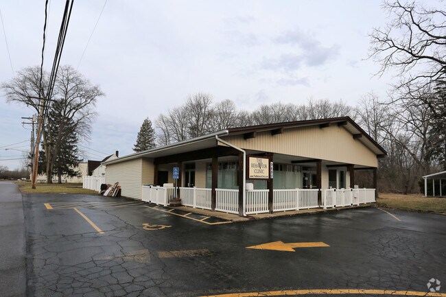
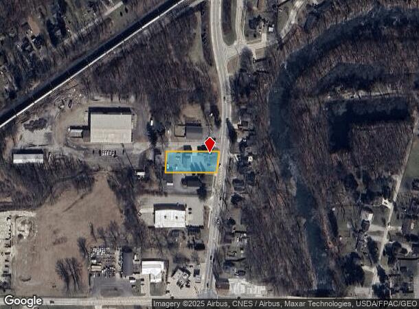
Property Record
9696 Columbia Rd, Olmsted Falls, OH 44138
NEARBY LISTINGS FOR SALE OR LEASE
Property Detail
9696 Columbia Rd
Cleveland-Elyria, OH
Capricorn Properties Ltd
291-04-006
3 PCLC 29104007 & 29104008
Officebuilding
Cuyahoga
X
Ohio
39035C0257E
c
2024
0.48 AC
2024
Southwest
176200
Cleveland
3,375 SF
DEMOGRAPHICS near 9696 Columbia Rd
1 Mile
3 Mile
5 Mile
2024 Total Population
4,627
42,556
99,674
2029 Population
4,609
41,738
97,896
Pop Growth 2024-2029
(0.39%)
(1.92%)
(1.78%)
Average Age
42
44
44
2024 Total Households
1,950
17,454
41,629
HH Growth 2024-2029
(0.82%)
(2.11%)
(1.99%)
Median Household Inc
$82,511
$86,004
$79,389
Avg Household Size
2.30
2.40
2.30
2024 Avg HH Vehicles
2.00
2.00
2.00
Median Home Value
$191,088
$218,570
$212,115
Median Year Built
1976
1976
1973
Nearby Places
Map Layers
Map Styles
 Street
 Aerial
- Restaurants
- Banks
- Shops
- Fitness
- Groceries
PUBLIC TRANSPORTATION
AIRPORT
Cleveland-Hopkins International
DRIVE
WALK
Distance
Cleveland-Hopkins International
18 min
8.0 mi
Freight Ports
Port of Toledo
DRIVE
WALK
Distance
Port of Toledo
124 min
103.4 mi
Nearby Properties
Address
Land Use
TOTAL SIZE
Lot Size
Zoning
Address
Land Use
TOTAL SIZE
Lot Size
Zoning
1,514 SF
23.65 AC
RSF-B
Address
Land Use
TOTAL SIZE
Lot Size
Zoning
278,056 SF
42.71 AC
R-40
Address
Land Use
TOTAL SIZE
Lot Size
Zoning
53,653 SF
30.83 AC
Address
Land Use
TOTAL SIZE
Lot Size
Zoning
46,133 SF
35.03 AC
RMF-A
Address
Land Use
TOTAL SIZE
Lot Size
Zoning
209,822 SF
26.92 AC
R-40
Address
Land Use
TOTAL SIZE
Lot Size
Zoning
381,528 SF
42.50 AC
GI
Address
Land Use
TOTAL SIZE
Lot Size
Zoning
334,360 SF
8.22 AC
MF-HD
Address
Land Use
TOTAL SIZE
Lot Size
Zoning
112,629 SF
9.62 AC
RSF-B
Address
Land Use
TOTAL SIZE
Lot Size
Zoning
59,296 SF
7.08 AC
CC
Address
Land Use
TOTAL SIZE
Lot Size
Zoning
141,245 SF
8.90 AC
1F1
Address
Land Use
TOTAL SIZE
Lot Size
Zoning
80,578 SF
46.73 AC
Address
Land Use
TOTAL SIZE
Lot Size
Zoning
188,031 SF
16.59 AC
R-40
Address
Land Use
TOTAL SIZE
Lot Size
Zoning
171,000 SF
10.17 AC
GI
Address
Land Use
TOTAL SIZE
Lot Size
Zoning
63,904 SF
19.62 AC
Address
Land Use
TOTAL SIZE
Lot Size
Zoning
90,351 SF
9.46 AC
D-5
Address
Land Use
TOTAL SIZE
Lot Size
Zoning
171.19 AC
RSF-B
Address
Land Use
TOTAL SIZE
Lot Size
Zoning
19,870 SF
16.12 AC
Address
Land Use
TOTAL SIZE
Lot Size
Zoning
91,557 SF
22.50 AC
MUPD
Address
Land Use
TOTAL SIZE
Lot Size
Zoning
64,106 SF
1.29 AC
CC
Address
Land Use
TOTAL SIZE
Lot Size
Zoning
121,778 SF
23.40 AC
D-3
Address
Land Use
TOTAL SIZE
Lot Size
Zoning
148,816 SF
7.95 AC
LI
Address
Land Use
TOTAL SIZE
Lot Size
Zoning
61,251 SF
1.89 AC
D-3
Address
Land Use
TOTAL SIZE
Lot Size
Zoning
30,076 SF
5.96 AC
CC
Address
Land Use
TOTAL SIZE
Lot Size
Zoning
61,294 SF
3.99 AC
P-2
Address
Land Use
TOTAL SIZE
Lot Size
Zoning
97,302 SF
7.89 AC
D-5
Address
Land Use
TOTAL SIZE
Lot Size
Zoning
142,734 SF
2.01 AC
R-O
Address
Land Use
TOTAL SIZE
Lot Size
Zoning
86,316 SF
9.51 AC
RSF-B
Address
Land Use
TOTAL SIZE
Lot Size
Zoning
42,305 SF
4.43 AC
SR
Address
Land Use
TOTAL SIZE
Lot Size
Zoning
43,005 SF
0.47 AC
Address
Land Use
TOTAL SIZE
Lot Size
Zoning
39,576 SF
5.02 AC
MUPD
The World's #1 Commercial Real Estate Marketplace
Connect with us
© 2025 CoStar Group
The information above has been obtained from sources believed reliable. While we do not doubt its accuracy we have not verified it and make no guarantee, warranty or representation about it. It is your responsibility to independently confirm its accuracy and completeness. Any projections, opinions, assumptions, or estimates used are for example only and do not represent the current or future performance of the property. The value of this transaction to you depends on tax and other factors which should be evaluated by your tax, financial, and legal advisors. You and your advisors should conduct a careful, independent investigation of the property to determine to your satisfaction the suitability of the property for your needs.