Property Record
97 Etna Rd, Etna, NH 03750


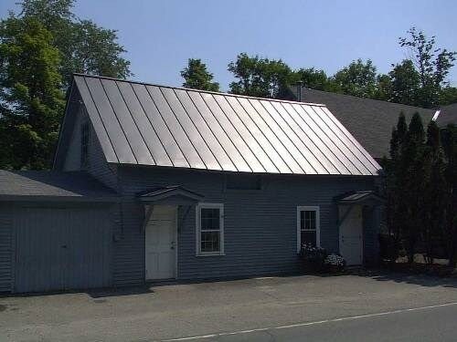
Property Detail
97 Etna Rd
HNOV-000029-000020-000001
Grafton
Commercialofficeresidentialmixeduse
New Hampshire
B1
1
AE The base floodplain where base flood elevations are provided. AE Zones are now used on new format FIRMs instead of A1-A30 Zones.
0.19 AC
2025
Concord/New Hampshire North Area
2025
Other Market Areas
961601
Lebanon-Claremont, NH-VT
3,380 SF
NEARBY LISTINGS FOR SALE OR LEASE
DEMOGRAPHICS near 97 Etna Rd
1 mile
3 mile
5 mile
2025 Total Population
444
6,772
28,619
2030 Population
436
6,962
29,128
Pop Growth 2025-2030
(1.80%)
+ 2.81%
+ 1.78%
Average Age
45
41
39
2025 Total Households
168
2,767
11,000
HH Growth 2025-2030
(1.79%)
+ 3.43%
+ 2.12%
Median Household Inc
$184,090
$120,248
$102,340
Avg Household Size
2.60
2.20
2.10
2025 Avg HH Vehicles
2.00
2.00
2.00
Median Home Value
$730,113
$641,501
$477,444
Median Year Built
1975
1989
1983
Nearby Places
Map Layers
Map Styles
 Street
 Aerial
Layers
 Traffic
 Biking
Places
Listings with unknown addresses are not visible on the map
- Restaurants
- Banks
- Shops
- Fitness
- Groceries
PUBLIC TRANSPORTATION
COMMUTER RAIL
White River Junction Amtrak Station (Vermonter - Amtrak)
Drive
Walk
Distance
White River Junction Amtrak Station (Vermonter - Amtrak)
18 min
8.6 mi
Freight Ports
Portland, ME
Drive
Walk
Distance
Portland, ME
202 min
166.4 mi
SALE & LEASE HISTORY
LISTING DATE
SALE/LEASE

Oct 18, 2018
For Lease
Nearby Properties
Address
Land Use
TOTAL SIZE
Lot Size
Zoning
Address
Land Use
TOTAL SIZE
Lot Size
Zoning
Address
Land Use
TOTAL SIZE
Lot Size
Zoning
163,845 SF
MC
Address
Land Use
TOTAL SIZE
Lot Size
Zoning
3,136 SF
53.32 AC
R1
Address
Land Use
TOTAL SIZE
Lot Size
Zoning
49.33 AC
Address
Land Use
TOTAL SIZE
Lot Size
Zoning
42.63 AC
R1
Address
Land Use
TOTAL SIZE
Lot Size
Zoning
137,168 SF
11.39 AC
GC
Address
Land Use
TOTAL SIZE
Lot Size
Zoning
1.55 AC
I
Address
Land Use
TOTAL SIZE
Lot Size
Zoning
191,951 SF
19.35 AC
R1
Address
Land Use
TOTAL SIZE
Lot Size
Zoning
81,782 SF
35 AC
I
Address
Land Use
TOTAL SIZE
Lot Size
Zoning
17.23 AC
INDL
Address
Land Use
TOTAL SIZE
Lot Size
Zoning
Address
Land Use
TOTAL SIZE
Lot Size
Zoning
4,225 SF
0.24 AC
I
Address
Land Use
TOTAL SIZE
Lot Size
Zoning
15,481 SF
1.47 AC
I
Address
Land Use
TOTAL SIZE
Lot Size
Zoning
0.25 AC
I
Address
Land Use
TOTAL SIZE
Lot Size
Zoning
1.23 AC
I
Address
Land Use
TOTAL SIZE
Lot Size
Zoning
128,514 SF
11.10 AC
R1
Address
Land Use
TOTAL SIZE
Lot Size
Zoning
169.73 AC
MC
Address
Land Use
TOTAL SIZE
Lot Size
Zoning
0.29 AC
I
Address
Land Use
TOTAL SIZE
Lot Size
Zoning
81,160 SF
2.61 AC
INDL
Address
Land Use
TOTAL SIZE
Lot Size
Zoning
0.21 AC
I
Address
Land Use
TOTAL SIZE
Lot Size
Zoning
0.25 AC
I
Address
Land Use
TOTAL SIZE
Lot Size
Zoning
Address
Land Use
TOTAL SIZE
Lot Size
Zoning
116.22 AC
MC
Address
Land Use
TOTAL SIZE
Lot Size
Zoning
75,077 SF
8.97 AC
INDL
Address
Land Use
TOTAL SIZE
Lot Size
Zoning
78,986 SF
3.71 AC
INDL
Address
Land Use
TOTAL SIZE
Lot Size
Zoning
74,917 SF
7.97 AC
INDL
Address
Land Use
TOTAL SIZE
Lot Size
Zoning
5,329 SF
117 AC
I
Address
Land Use
TOTAL SIZE
Lot Size
Zoning
0.87 AC
I
Address
Land Use
TOTAL SIZE
Lot Size
Zoning
81,220 SF
0.46 AC
I
Address
Land Use
TOTAL SIZE
Lot Size
Zoning
13,876 SF
32.10 AC
BM
The World's #1 Commercial Real Estate Marketplace
Connect with us
© 2026 CoStar Group
The information above has been obtained from sources believed reliable. While we do not doubt its accuracy we have not verified it and make no guarantee, warranty or representation about it. It is your responsibility to independently confirm its accuracy and completeness. Any projections, opinions, assumptions, or estimates used are for example only and do not represent the current or future performance of the property. The value of this transaction to you depends on tax and other factors which should be evaluated by your tax, financial, and legal advisors. You and your advisors should conduct a careful, independent investigation of the property to determine to your satisfaction the suitability of the property for your needs.